EasternLI
-
Posts
3,372 -
Joined
-
Last visited
Content Type
Profiles
Blogs
Forums
American Weather
Media Demo
Store
Gallery
Everything posted by EasternLI
-
Yeah, has that look. Agree. Just want to see the atmosphere produce a couple flakes. This is what we've been reduced to
-
Rap saying maybe for later on today
-
Yeah, that's where I'm at too. I've been thinking that for a while. I'm with you on this. Maybe we send the vortex on the Alaskan tour and fire up a warm spring. That would be fine with me after this mess.
-
Eps happens to display a colder option within the same context of what I was talking about. Just by shifting the orientation a little bit. Just something to be mindful of. Possible, but we all know how that goes.
.thumb.png.22a4c5ce504c02cb445a68bab9e643d5.png)
-
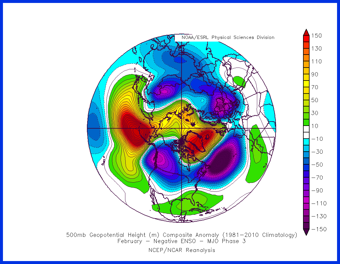
Maybe phase 4 to follow what I was referencing. Hard to say, that's way way out there. Looks like we could just shift the vortex to Alaska eventually lol
.thumb.png.0790f87b61f31b3732490f6ef4c84c74.png)
-
No you do not. However, the atmosphere needs to be receptive. This would be a very hostile condition for the time being.
-
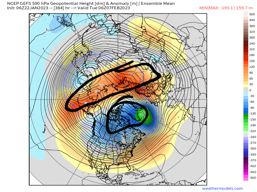
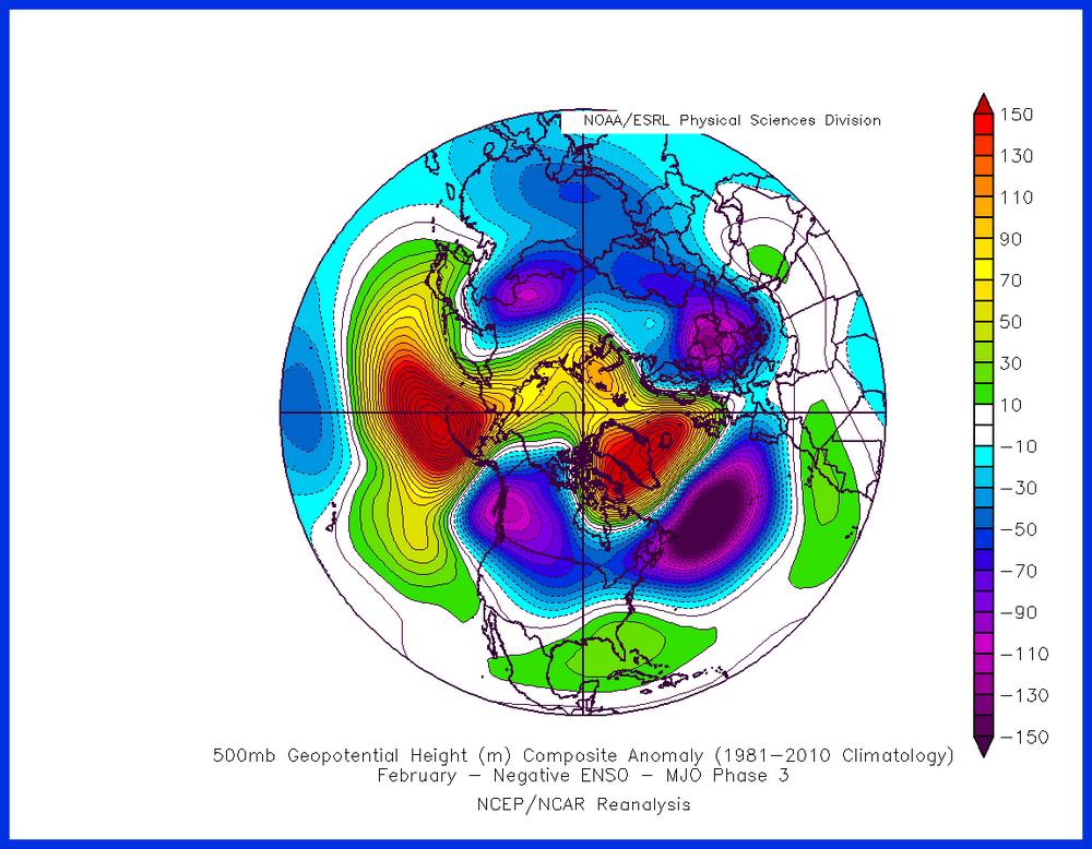
Quickly piggybacking off the strat post. So then if you look at what the gefs is doing in the long range. It makes sense that you would see a strong vortex near Greenland. Also, the troposphere had wanted to push ridging poleward due to previous events. That would have been the phase 3 composite I posted days ago. But you can also see now, that gets "blown away" by the strong winds descending from above. Dynamics in the stratosphere are consistent with this solution during this time. It's a nice example of how different factors work together. Even if it isn’t in the way we would hope.
-
Looks that way. Yeah.
-
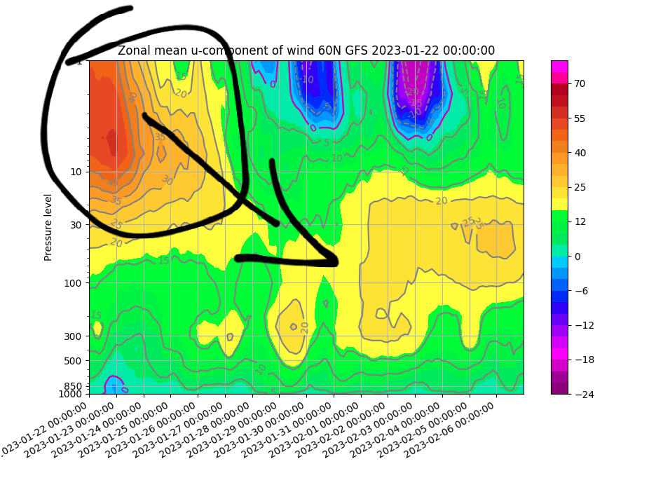
Since I last posted on the stratosphere. Cross guidance trends have been unfavorable for getting it done. There's still warming ahead, but it looks increasingly clear to me like it will fall short of what we would need. Here's the latest gefs trends illustrating this. So what could that most likely mean. There's still some warming modeled. Here's the cross section of the 00z gfs as a guide. Note the strong winds high up in the stratosphere. Associated with the stronger than normal SPV currently. With weakening winds arriving at the time of the warming. Notice how the warming weakens the winds higher up, but this is pushing down the stronger wind into the troposphere. But the warming isn't going to be enough to finish the job. So what are we left with. I'd say most likely that means no help from this. As it actually acts to strengthen the vortex in the troposphere instead (+AO) by pushing the stronger winds down from above. With the SPV regaining strength again following this as hinted on latest guidance. Could happen later I suppose, but I really rather not by then as the hour is getting extremely late. Hopefully this is at least a little helpful for those more curious about the nuance of it. Ideally, a stronger event would push the reversal of winds down through the atmosphere into the troposphere. Which is how the arctic blocking can emerge. That looks very unlikely today.
.png.c193d70d2ff511cb254d1feb7ec05f58.png)
-
Brutal
-
$20 on the torch.
-
Filthadelphia? Not a fan. Let's go Giants!!
-
-
It's so weird though. And I've seen this happen on several runs now. With the strat warming, I'm seeing troposphere alterations like simultaneously. That's abnormal isn't it?
-
We 2001-2002.... All of the cold has been firmly planted on the other side of the planet for the most part. Our winters have never been good here when this happens. It gets warmer here now than it used to though because the world is getting warmer. This is just reality. I feel like we need the ssw to come through, with it's associated effects, if we are to crawl out of the basement at this point. That's about all I see that could offer a large scale shake up which we need. With that being said, even if we get one, it still may not matter because there's no guarantee how it might play out. But if we don't, I think we stay locked in the basement and siberia stays locked in the freezer.
-
Another stratosphere post since the target timeframe is approaching 10 days now. Dr Butler tweeted yesterday she referenced the nasa GEOS model. Without a doubt, this is who to pay attention to for this. So here's the GEOS model from overnight at day 10. Fairly robust run. Be interesting to see what trends or doesn't with this over the next several days. Gefs was a little more enthusiastic about it overnight also. Just starting to come into view on the euro as well. So we observe.
.png.5dac841836bf76ea33000f1be9ed3d05.png)
.thumb.png.097c1e26213ad4c35d4a4d0f09ad6c0c.png)
-
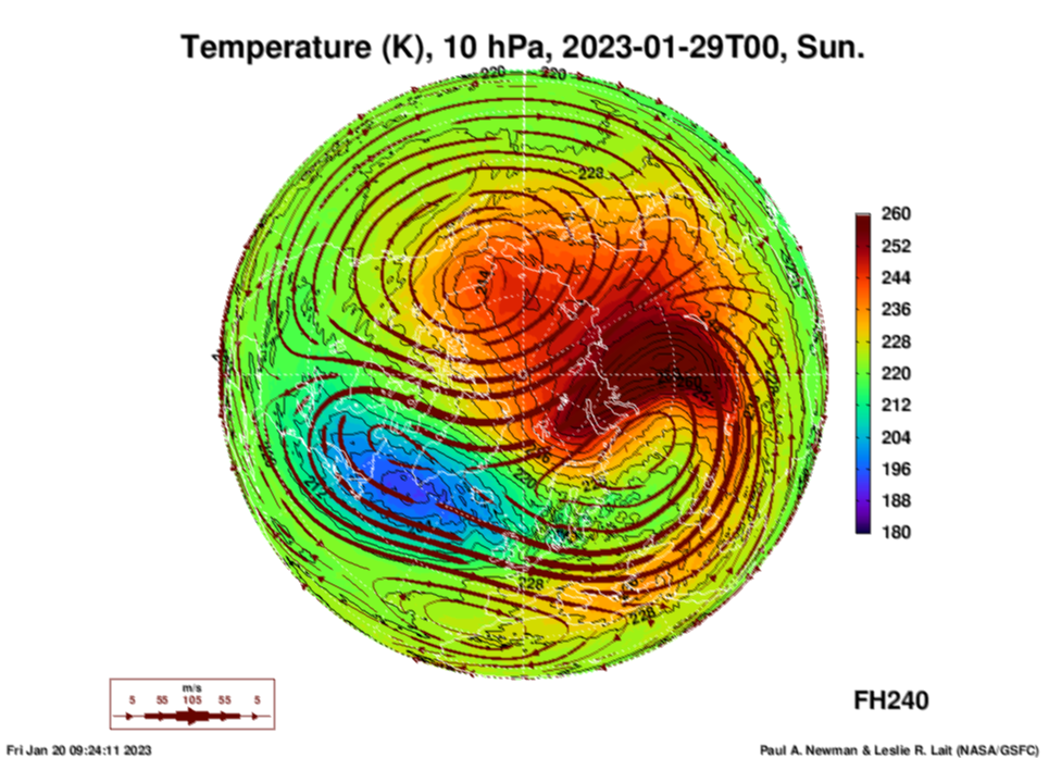
It's a giant ridge in the arctic stratosphere, following a ssw. Sell for the time being.
-
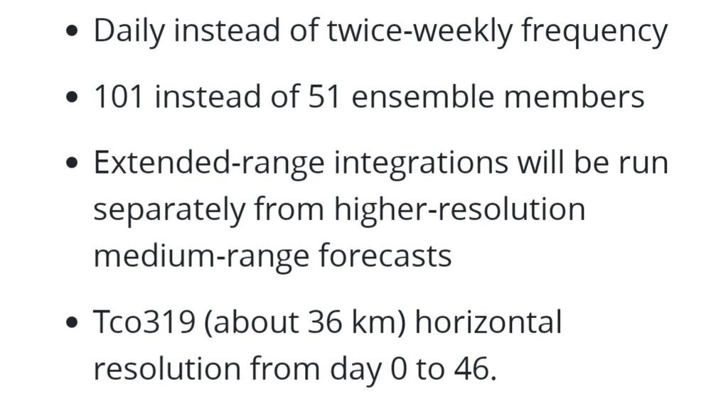
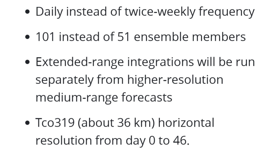
Pretty big update upcoming this year on those. Where they will now run separately from the 00z eps. Instead of as an extension, like now. Double the members. Plus run it every day. I'll be interested to see how these do following that. My biggest issue with them has always been because they just extrapolate the 00z eps. That's not going to be the case anymore after this. These sound like very promising changes to me. Looking forward to this. https://www.ecmwf.int/en/newsletter/173/earth-system-science/next-extended-range-configuration-ifs-cycle-48r1
-
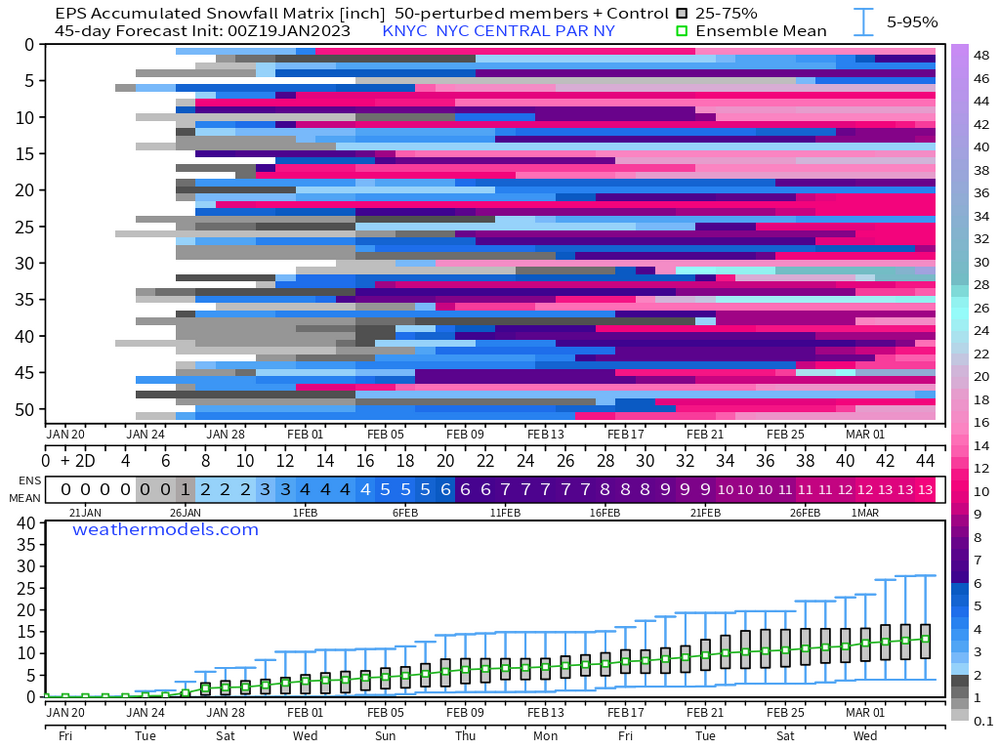
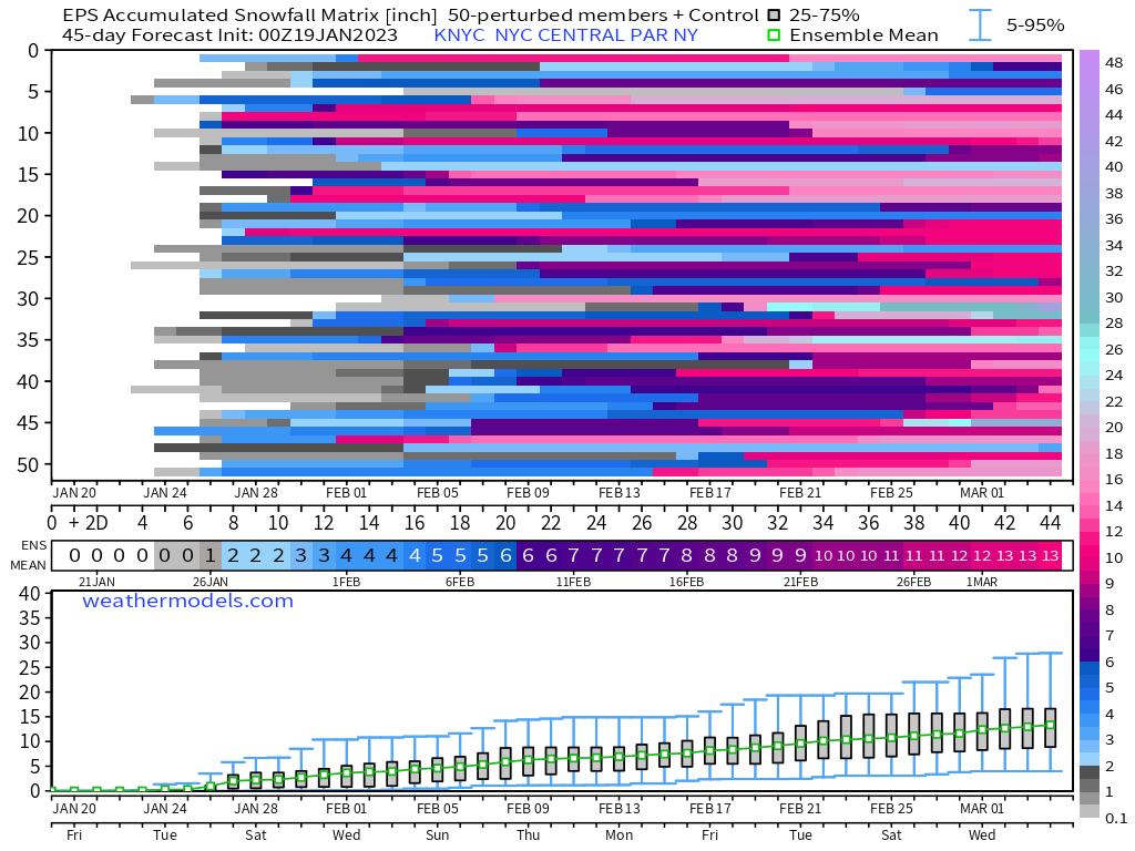
Just for entertainment value. As bad as those weeklies look, 100% of the members do get at least some snow into NYC at one point or another.
-
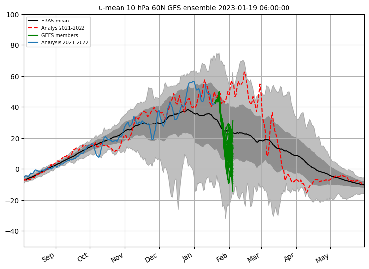
Just taking a peek up into the stratosphere guidance this morning. Just because some may be interested to see some of the real data. Let's check the status. It's already disturbed somewhat from the earlier shots of warming. Here's initial conditions on the euro. There's another good shot scheduled up in 6 days. Here's the euro again. Euro is slightly stronger than the GFS with this. Another one setting up to follow that one up. Here's the euro again, Gfs has the same general idea as does gefs and eps. Here's the 06z gefs, which has 39% of the members achieve a technical ssw. That number fluctuates greatly from run to run, but that's the highest I've seen it so far. So figured I'd mention it. May all be meaningless in the end, of course. We all realize this. Seems interesting enough to keep an eye on it to me though. Something is happening there, may as well watch it.
.thumb.png.d9e56a44f4e93c5f6a1d98f10345c54d.png)
.thumb.png.7000d96a25caaa08b3905c889b453df9.png)
.thumb.png.25623178a49a3b3782932ab6c951965e.png)
-
I actually thought the eps did a better job squashing the se ridge last night. With a bit less of a western trough late. Regardless, I'm just not thinking very much about beyond day 7 currently with strat activity ramping up in this period. Yesterdays 12z eps Last night's 00z
.thumb.png.259bf7e53cc7738950f4ce54fdf141f3.png)
.thumb.png.11355a7d220fdf79f483e3e39778475d.png)
-
This really is a pretty reasonable match everywhere with everything on 18z GEFS. We're pulling for the Greenland ridge here. To work with whatever happens with the strat. So get out the lucky rabbit foot, four leaf clover, lucky underwear, plus whatever else you might have.
.thumb.png.b91118fb420d2000c7780959f439f07e.png)
-
This is what I've been trying to communicate about that situation. That is what made it interesting for me. Just having the possibility of something like that. Requires pulling a rabbit out of a hat though lol.


.png.5e6e3e0950ca82ffb33a97227d520073.png)
.png.6e48fb5afed152e0a95c1101f679abf5.png)


.png.4e50cc5278ea72ce063fd313e2c33675.png)
.png.b491ab973f4fecb40ed30f5b9079acd9.png)
.png.f47a040dc0a23e308bbaa9ec17e3868d.png)
.png.c482ce503349be5ca972b88f98a23e28.png)
.png.3b4d94e95b350b9af190df4d50e943c4.png)
.png.303d6087ba5b76e18e8ce0ed7a4ad346.png)
.png.eec1bcc5bc10f70b1f65f5e42ae27d79.png)