EasternLI
-
Posts
3,372 -
Joined
-
Last visited
Content Type
Profiles
Blogs
Forums
American Weather
Media Demo
Store
Gallery
Everything posted by EasternLI
-
It's a game again lol
-
Yup. 49ers in trouble quickly lol
-
We 2001-2002...
-
Crash Eagle's Crash
-
Roy Munson winter
-
~5th doesn't look so terrible for some kind of system. The vortex is lifting away from our lap. Leaving some cold available. We do get windows in those situations. Timing that right, that's another story.
-
-
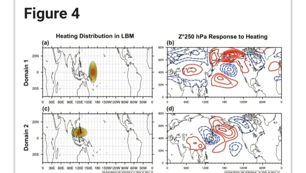
Just to tack on to this quickly. The following figure from the following article, nicely displays what we would like to see instead. Bias this further east towards the central Pacific, you can get a nice Pacific. Biased west, extending towards the Indian Ocean, we can get what we've seen. https://www.nature.com/articles/s41598-019-49449-7

-
Yup. Boring winters are the worst. This one is evil though. How dare you flash us that December block, fail on that completely, then do this. Shoot it into the sun.
-
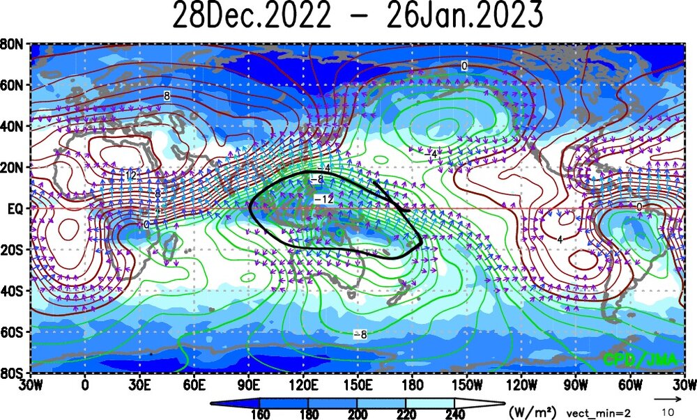
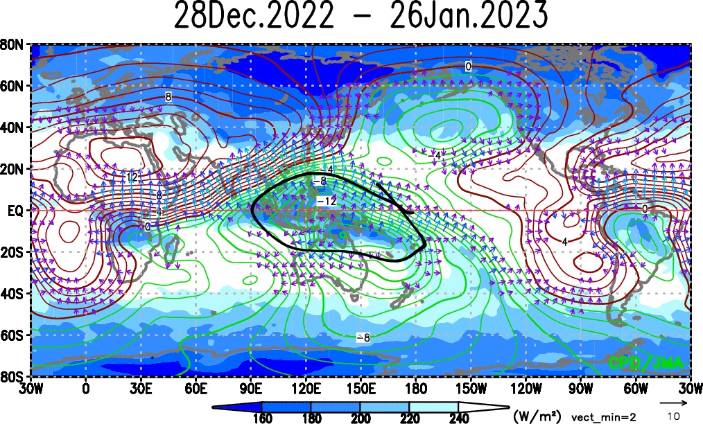
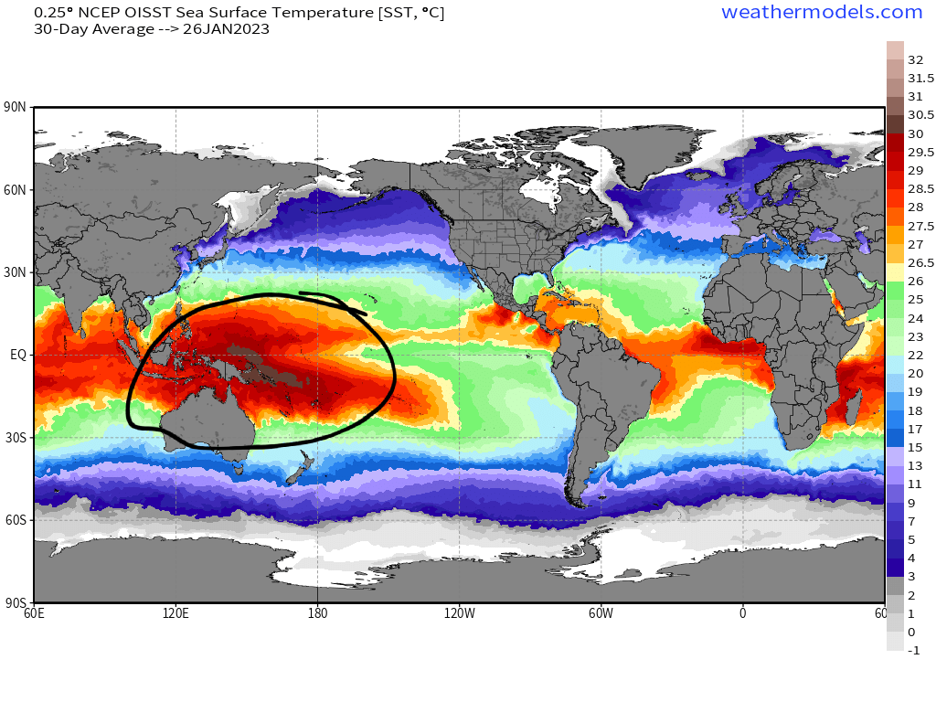
Past 30 days of OLR(shading) with 200mb velocity potential from JMA. Past 30 days of sst averaged. Warm pool did the heavy lifting in the tropics this month. You'd expect a horrible Pacific with this type of positioning here. Just like we got. I have a theory about why the Pacific jet may have remained supercharged for so long as well. With the TPV parked in siberia for the bulk of the month. Which set some cold records there. Then you have this warm pool sitting directly south of that. I'm wondering if that sharp temperature contrast between the two features at least helped that happen. The longevity of it. Can't prove that right now, but it's a idea.
-
Ah yes, this is the standard operating procedure of the weather weenie. We all know it well. You're having a better time than me. Here's a live look at my situation:
-
Yeah, I'm just having some fun. So very much goes into it. I'm becoming more and more of a believer that the PDO plays a tremendous role too. The more I read about that in updated research. Same idea with the gradients. I feel like this was a major factor in 95-96 TBH. La nina, but positive PDO that year. I think that helped us out. Quite rare to see that with la nina.
-
Can be, have to be careful though
-
And that's true also. That's because they set up too much of a gradient. Same thing with strong la ninas. It's usually too overwhelming. Where it's positioned matters too. These circulations alter the jet stream. It's all such a fine balance. That's without even adding anything else into that equation lol. And there's a lot. But this is one of our most important factors for sure. Since it happens in the Pacific.
-
Right. That's one way to do it. The other way is to see some cooling of that warm pool. And that's still possible at times as well, because there's still going to be at least some variation with it. Like there is with enso. That feature has the ability to take control of global weather patterns though. Since it's intrinsically linked with enso. So I personally have some grave concerns about that feature continuing to warm in the future.
-
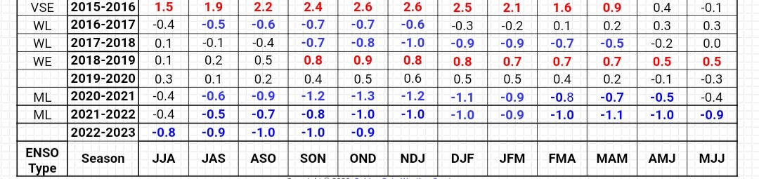
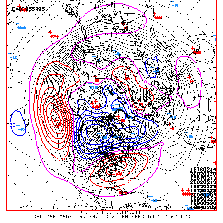
So 1918 seems to be another very interesting case actually. If others are interested, like I was. I only recently stumbled upon the NOAA enso reconstruction dataset. So I've been browsing. That timeframe sticks out. 1918 would have been part of the strongest la nina event of all time, according to that data. Going back to 1300 (!). Also, a 3 year event in the 3rd year. Which produced the following 500mb that January. Pretty wild. Three consecutive el ninos followed this. 1916 -0.907 1917 -3.724 1918 -2.315
.png.0d3ac5121d5b50dac2d4498bac51eba7.png)
-
I think it's everything together. I think that Pacific warm pool is a big deal though. I fear that thing. I strongly believe it's playing a role with that as it likes to drive a -PNA typically. So that's a logical response to that. But I also think la nina is amplifying that response to an extent since then. Because we seem to be in a la nina like cycle since then as well. By increasing the gradient next to that warm pool. Amplifying it's effectiveness. We did have the weak el nino in 18-19. However the gradient was non existent to the west of that because of that warm pool. So I think this is why that one acted atypical and more enso neutral like. No contrast. Same sort of situation for 19-20. This makes me very skeptical of the next el nino as well though. We'll need to see some gradients. Otherwise I think it's going to be useless again.

-
NYC next week
-
Yes, well said. Same page. Root of that is the Hadley cell expanding too. Causing those things IMO.
-
I don't see why 2 things can't be true together. This pattern is utterly disastrous, true. The planet is getting warmer, true. So here we are. I don't think it's a question of one versus another. It was only a matter of time before these 2 factors converged to produce a snowless season. Maybe it's this one. TBD
-
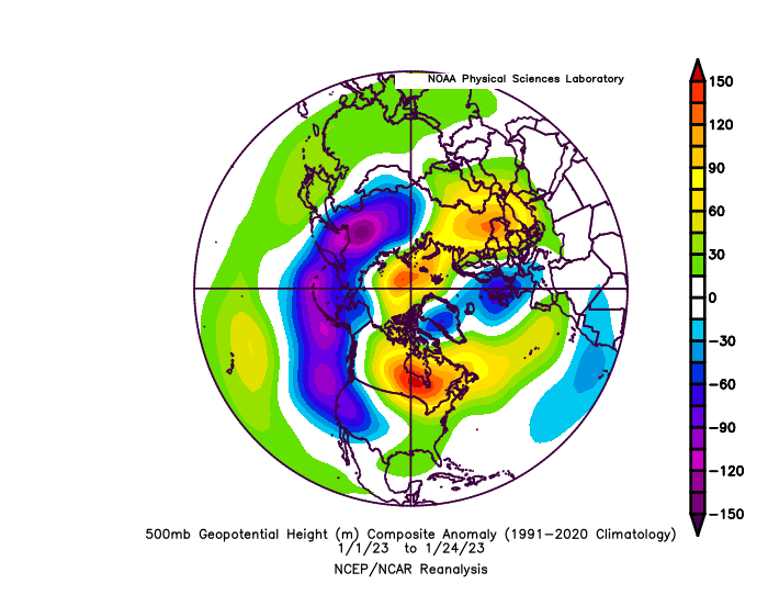
What an amazingly putrid Pacific this January has been too. You'd be hard pressed to draw it up much worse than this. Looks a little bit like the 1933 January Pacific did actually, but with a much much flatter Pacific Ridge this year. Wildly bad. Feel free to fade away la nina.
.png.f7e91236ab41d7ab0130d47c89089896.png)
-
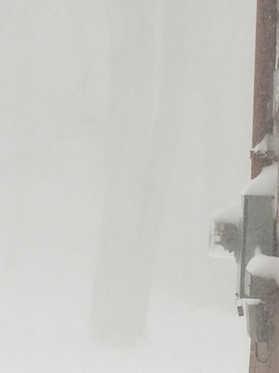
I have a couple 2015 pics somewhere. Can't find them at the moment. However I came across one from January 2018. There's a tree directly in front of me, and you can barely see it lol.


.png.bcbbbfd8f849f936ccaa7233fe3564ff.png)
.png.a475c94eff492844350c5082c82e8966.png)