Tyler Penland
-
Posts
2,569 -
Joined
-
Last visited
Content Type
Profiles
Blogs
Forums
American Weather
Media Demo
Store
Gallery
Everything posted by Tyler Penland
-

2024-2025 Fall/Winter Mountain Thread
Tyler Penland replied to Buckethead's topic in Southeastern States
That's a lot of precip over central TN that wasn't supposed to be there last night. -
2024-2025 Fall/Winter Mountain Thread
Tyler Penland replied to Buckethead's topic in Southeastern States
Absolutely hammered for a bit. 1.5" now. Kicking and crawling our season total up to 7.8". -
2024-2025 Fall/Winter Mountain Thread
Tyler Penland replied to Buckethead's topic in Southeastern States
Just hit 1". -
2024-2025 Fall/Winter Mountain Thread
Tyler Penland replied to Buckethead's topic in Southeastern States
22 with light flurries/diamond dust here this morning. Very pretty. -
2024-2025 Fall/Winter Mountain Thread
Tyler Penland replied to Buckethead's topic in Southeastern States
Glancing at the Euro soundings verbatim it is very, very close to staying all snow in the mountains on Monday. I would imagine the warm nose wins (it almost always does) but it is very close. -
2024-2025 Fall/Winter Mountain Thread
Tyler Penland replied to Buckethead's topic in Southeastern States
I wondered when the cold front was gonna get here. Barely any wind in Blowing Rock all day but its breezy here at the house now. -
2024-2025 Fall/Winter Mountain Thread
Tyler Penland replied to Buckethead's topic in Southeastern States
NAM looks solid overnight. Should hit the high elevations decent. GFS on a bit of an island with the CAD event Monday but plenty of time for that to change up. I'm scheduled to be working in Asheville so you can bet on a sleet/ZR storm down there at least. -
2024-2025 Fall/Winter Mountain Thread
Tyler Penland replied to Buckethead's topic in Southeastern States
Until we can get one of these bigger things under 240 hours I'll believe it when I see it. Remember the extended for the end of December was an extreme torch and that didn't work out. No reason to believe the opposite will be true 2 weeks from now. -
2024-2025 Fall/Winter Mountain Thread
Tyler Penland replied to Buckethead's topic in Southeastern States
Sitting quite literally at the top of the wedge right now. 43 degrees a quarter mile downhill from me. 51 and windy here imby. -
2024-2025 Fall/Winter Mountain Thread
Tyler Penland replied to Buckethead's topic in Southeastern States
12z GFS real real close to a mountain whopper next week. That time frame has been showing potential for a bit now. -
2024-2025 Fall/Winter Mountain Thread
Tyler Penland replied to Buckethead's topic in Southeastern States
3/4" here overnight. Still a bit of light stuff falling this morning. Stuck to absolutely everything, quite pretty. -
2024-2025 Fall/Winter Mountain Thread
Tyler Penland replied to Buckethead's topic in Southeastern States
I think we got about 5 raindrops out of this somehow. Really like the look of Friday night. Too bad I gotta work Saturday lol -
2024-2025 Fall/Winter Mountain Thread
Tyler Penland replied to Buckethead's topic in Southeastern States
Up at Grayson Highlands. Was hoping for some good rime ice but while it is 25 and ridiculously windy not much to report in the way of snow/time ice. A good 4-6" of needle ice in spots though lol -
2024-2025 Fall/Winter Mountain Thread
Tyler Penland replied to Buckethead's topic in Southeastern States
Was 52 at 9:30. Currently 38 with snow mixing in in Blowing Rock. -
2024-2025 Fall/Winter Mountain Thread
Tyler Penland replied to Buckethead's topic in Southeastern States
Nope only had 8" here from that one. Right at 16" in '18. Which means I have had one at half. Actually forgot we made it to 8 in the 22 storm. -
2024-2025 Fall/Winter Mountain Thread
Tyler Penland replied to Buckethead's topic in Southeastern States
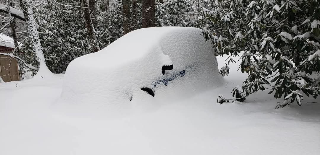
6 years ago today. Haven't seen an event with half this total since. I've had 2 winters not even see a season total this high.
-
2024-2025 Fall/Winter Mountain Thread
Tyler Penland replied to Buckethead's topic in Southeastern States
Still a warm up, rain, cold, repeat pattern though. Trending in the right direction just need it to keep going. Next Wed/Thu is interesting. -
2024-2025 Fall/Winter Mountain Thread
Tyler Penland replied to Buckethead's topic in Southeastern States
Wednesday night looking interesting with the frontal passage. NAM has an almost convective look to it. I hope so, I'm off Thursday so I can actually enjoy it lol. Haven't had a snowy day off yet. -
2024-2025 Fall/Winter Mountain Thread
Tyler Penland replied to Buckethead's topic in Southeastern States
We definitely got downsloped this time. Not surprising, we do better here with a more northerly component. 1.5" though. -
2024-2025 Fall/Winter Mountain Thread
Tyler Penland replied to Buckethead's topic in Southeastern States
Not sure what MRX is doing but they have us at a 20% chance of snow overnight. They completely missed last night and this morning, though. Moisture plume looks decent out around Bowling Green. -
2024-2025 Fall/Winter Mountain Thread
Tyler Penland replied to Buckethead's topic in Southeastern States
Hasn't stopped here yet. This was the scene when I got to the store this morning.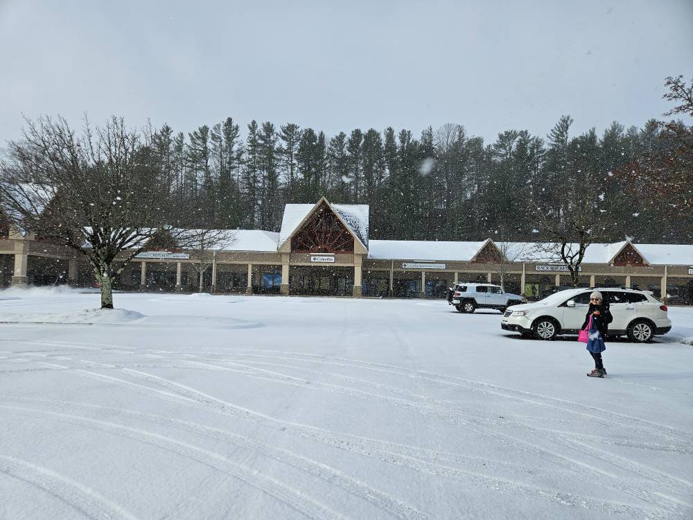
-
2024-2025 Fall/Winter Mountain Thread
Tyler Penland replied to Buckethead's topic in Southeastern States
No additional accumulation overnight but it started absolutely ripping here about 20 minutes ago. -
2024-2025 Fall/Winter Mountain Thread
Tyler Penland replied to Buckethead's topic in Southeastern States
Solid half inch or more so far. Roads around Boone are a mess. -
2024-2025 Fall/Winter Mountain Thread
Tyler Penland replied to Buckethead's topic in Southeastern States
Had a little dusting this morning. Actually flurried/flizzarded on and off most of the morning in Blowing Rock. Nice day. Wind is rocking now. -
Mid to Long Range Discussion ~ 2024
Tyler Penland replied to buckeyefan1's topic in Southeastern States
So for some reason they've decided this isn't the case for the time being. Park Service announced the other day that it is closed to all recreation when the gates are shut due to potential for downed trees and unstable ground. I think its a bit of an overreaction but that's what they've decided to do for now. Honestly a little tired of how easily public lands are getting closed since the pandemic. But yeah, most businesses saw at least a 70-80% drop in sales in October. We would love the tourism.