

Tyler Penland
-
Posts
2,523 -
Joined
-
Last visited
About Tyler Penland

- Birthday 11/15/1991
Recent Profile Visitors


-

2026 Spring/Summer Mountain Thread
Tyler Penland replied to Buckethead's topic in Southeastern States
Aight one day of heat back and I'm already over it. Bring on fall/winter. Heading to the North Wilkesboro races this weekend and the trucks are at 12:30 on Saturday afternoon. -
2026 Spring/Summer Mountain Thread
Tyler Penland replied to Buckethead's topic in Southeastern States
My station made it to 90.5 this afternoon. As far as I can remember that's the first time I've ever recorded a high above 90 here at the house. Yesterday was 89.3. Sent from my Pixel 10 Pro using Tapatalk -
2026 Spring/Summer Mountain Thread
Tyler Penland replied to Buckethead's topic in Southeastern States
We managed to hit 42.1º this morning. Much cooler than I expected. The station right below me directly on the river hit 40.3º. Wild. I was hiking up at Grayson Highlands yesterday and it was in the mid-40s all evening. Definitely an odd, but very nice day out for early June. -
2026 Spring/Summer Mountain Thread
Tyler Penland replied to Buckethead's topic in Southeastern States
Only dropped to 35.6º last night. My wife's raised bed vegetables are thankful. -
2026 Spring/Summer Mountain Thread
Tyler Penland replied to Buckethead's topic in Southeastern States
Low of 31.6º this morning. Been enjoying the cool temps. Looks like finally some legitimate rain this weekend- we need some or spring flower season is going to suck. -
2026 Spring/Summer Mountain Thread
Tyler Penland replied to Buckethead's topic in Southeastern States
0.06" overnight- bottomed out at 37º this morning. Saw some reports of flurries around but never saw any myself here at the house. -
2026 Spring/Summer Mountain Thread
Tyler Penland replied to Buckethead's topic in Southeastern States
I managed a grand total of 0.01" overnight last night. Just enough to make the truck look even worse dirty. -
2025-2026 Fall/Winter Mountain Thread
Tyler Penland replied to Buckethead's topic in Southeastern States
Hard to argue with how this winter went, although I certainly would've liked to have seen more than 5" at a time. I ended the year with right at 20", pretty solid and right on average. I've seen plenty of below-average winters since moving up here so an average year is a win for me. That absolutely gorgeous December snow also gives a boost. -
2025-2026 Fall/Winter Mountain Thread
Tyler Penland replied to Buckethead's topic in Southeastern States
Just rolled into Daytona, heading down for the (hopeful) Artemis launch tomorrow. I always, and I mean every single time, forget how miserable the humidity is once you get south of the NC line. Brutal. -
2025-2026 Fall/Winter Mountain Thread
Tyler Penland replied to Buckethead's topic in Southeastern States
We must've gotten under a nice band overnight because I went to bed at 1/2" and woke up to a solid 3". Very nice surprise! -
2025-2026 Fall/Winter Mountain Thread
Tyler Penland replied to Buckethead's topic in Southeastern States
Starting to cover the grass here in Blowing Rock now. Took forever to switch over but hammering now. -
2025-2026 Fall/Winter Mountain Thread
Tyler Penland replied to Buckethead's topic in Southeastern States
Webcams show switch to snow in Boone. Still rain here in Blowing Rock but I suspect for not much longer -
2025-2026 Fall/Winter Mountain Thread
Tyler Penland replied to Buckethead's topic in Southeastern States
Huge temp crash in Blowing Rock, down 10 degrees in the last 12 minutes. -
2025-2026 Fall/Winter Mountain Thread
Tyler Penland replied to Buckethead's topic in Southeastern States
The temperature trace in Franklin since 2AM is really something. From 55 to 35.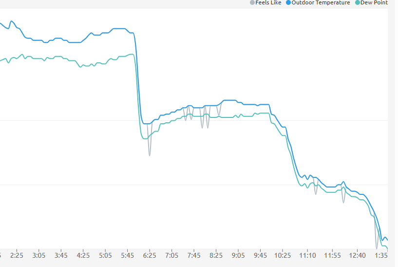
-
2025-2026 Fall/Winter Mountain Thread
Tyler Penland replied to Buckethead's topic in Southeastern States
Wind absolutely howling this evening. Fun 24 hours ahead no doubt. Sent from my Pixel 10 Pro using Tapatalk
