

KokomoWX
-
Posts
1,558 -
Joined
-
Last visited
Content Type
Profiles
Blogs
Forums
American Weather
Media Demo
Store
Gallery
Everything posted by KokomoWX
-
It’s pouring snow in Kokomo. .
-
Such nonsense.
-
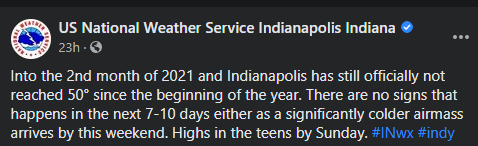
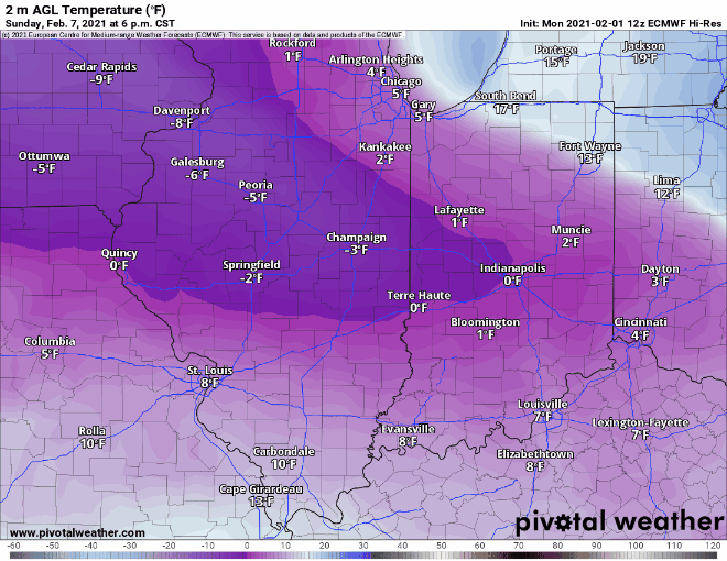
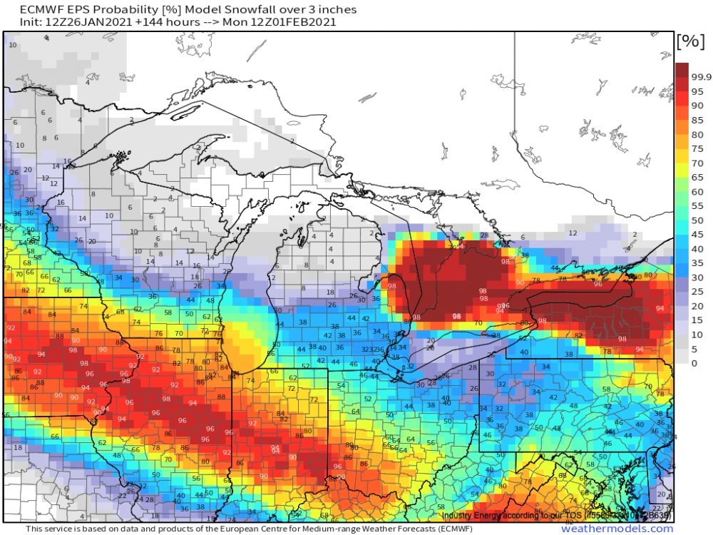
It continues to look brutal for the long haul.
-
Euro 12z never let up thru day 10.
-
Some good news when you take a real look at the data... Source from the daily NYT Covid newsletter:
-

Winter 2020-21 Medium/Long Range Discussion
KokomoWX replied to Hoosier's topic in Lakes/Ohio Valley
The GFS v16 snaps back by the end of the run to 50's and 60's across IL, IN, & OH. Hopefully the brutal cold will not be sustained. -
I finished with 5-6" with some reports as much as 8" locally in western Howard County and Burlington. This was cement all the time with some rain that really made it a wet mess. The snow plows throwing the heavy stuff have done a number on mailboxes; mine included. Unlike about every storm in recent memory, this snow will not melt away the same or next day. It has been a while since I had any semblance of a snow pack. I did enjoy getting out last evening driving around during the heaviest snow and then again this morning to see the results in daylight. Mood flakes falling now but not really expecting any accumulations. Congrats to all who cashed in and I'll be greedy and ask for more IMBY and soon. I'm watching next weekend and the possible sub zero temperatures to follow. Bring it on for now. (I'll admit I did get a bit excited at possible double digits with the SREF Plumes and HRRR going full out at the vert last minute.)
-
Unofficial report of 2.5” in Bloomington, IN.
-
I am also out with a 4 wheel drive truck and camera and video gear. Can wait for the main slug to get here.
-
A small squall ahead of the main system has coated everything. We were 34 at the start but it fell as snow and in less than an hour we have dropped to 30. The 1” rates in Indy have me excited. Snow reports all the way back to Bloomington, IN and Terre Haute. Feeling primed for an over performer. HRRR has been pumped for the area the past few runs.
-
Indy: A few interesting observations at 15Z...temperatures throughout the mid Mississippi Valley and into western Illinois are generally running a few degrees lower than the bulk of the CAMs had progged for mid morning. This supports the concern many mets shared over the last 24 hours or so that overall model guidance was attempting to advect temperatures that were too warm too far north by late today. Even now...the HRRR for example tries to bring temps near 40 up to or just north of the I-70 corridor by 21Z which seemed far too overzealous to begin with and in light of the current temp trends looks that much more unrealistic.
-
or...
-
Kokomo final call - 4-6" I just think the warm air and low ratios (7:1) will eat away at the total. The 18z HRRR does show a solid 8-9" county wide though so hopefully I'll bust low with my call.
-
NWS Indy is eluding to it in the afternoon AFD. The primary focus for the extended will be on the potential for a high impact winter storm over parts of central Indiana this weekend. In addition as has been expected since the Fall...this appears to be the opening salvo to the transition to a much more active weather pattern that may set the stage for the second half of the winter. An additional higher impact storm already appears on the horizon near the end of the forecast period later next week.
-
It would be nice to get the moisture and the cold at the same time. I am holding out hope in Kokomo but know it is probably fruitless to wish for a 6" storm.
-
Fort Wayne is the new winner with the NAM at 14.2 inches. Lots of good QPF for those on the southern edge but so much marginally warm air. The ice threat is back too.
-
Lock it in! (I think this is my first real chance at a 6"+ storm in a very long time.)
-
You showing no love for those south. This is our storm.
-
So I'm getting sleet.
-
Best chance we have had all year!
-
Bring on spring. The pattern change, if happening, ain't doing crap.

-
Looks like a couple of weeks until Johnson and Johnson gets approval of its single dose vaccine. Super easy storage requirements will be a plus too. https://nypost.com/2021/01/23/fauci-johnson-johnson-covid-vaccine-may-get-approval-in-2-weeks/
-
It is eleven degrees this morning and just a day away from a solid snow storm to my north. The cut-off will be sharp and I'll be whiffed again. So many misses both north and south over recent years. My last 6" snowfall was Jan 12/13, 2019. Since then we had the over performer on December 16th this season for 4.2" but zero other 4+ inch snowfalls. March 25, 2013 was the last time I saw double digits. You can guess that it didn't last long. There have been just 11 events with 4 or more inches since the beginning of the 2012-2013 season. A bit further back was the sleet fest of GHD where models show Kokomo getting buried only to get 6 inches or so of sleet. FML Kokomo is due. I'm due. Looking at something coming up mid week and seeing I'll be riding the south gradient but will likely see mostly mixed at best is heartbreaking. I'm so tired of the complete turds I've been getting. I am ready to say screw it and wish for a torch that would make March 2012 seem like a cold shower. Bring it on the heat baby.
-
I've worn my mask indoors and been out and about and have been dining inside at least once or twice per week. I'm also in K-12 education around several thousand of student and staff. We have been in school since August when the school year began. I also vacationed out of state in the fall. I think my secret to not getting sick at all throughout has been good hygiene, some social distancing mask wearing, and a regiment of vitamins taken twice daily. Elderberry Gummies - 260mg Sambucus, Vitamin C and Zinc D3 - 50 mcg C - 1000 mg B12 1000 mcg Nature Made Men's Multivitamin + Omega-3 Gummies Benadryl Alergy I did direct work with three people who have large families and play sports who did catch the virus and exhibit symptoms so I'm doing something right. I'm hoping for a vaccine for school staff come soon. I'm just a few months away from the age 60 cut off in Indiana.
-
I see the ice maps don't have a good feeling for Kokomo.


