
bearman
-
Posts
593 -
Joined
-
Last visited
Content Type
Profiles
Blogs
Forums
American Weather
Media Demo
Store
Gallery
Everything posted by bearman
-
There just never seems to be any consistency.
-
Anybody in the Knoxville area. We are coming in from FL on a flight this afternoon and was wondering how much Knoxville Got. Any Reports there?
-
Don't know why anyone would expect anything different it almost always happens. it seems. Lucy always pulls to ball out of the way before its kicked.
-
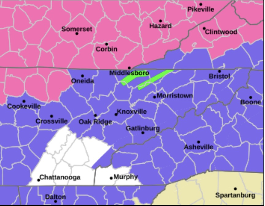
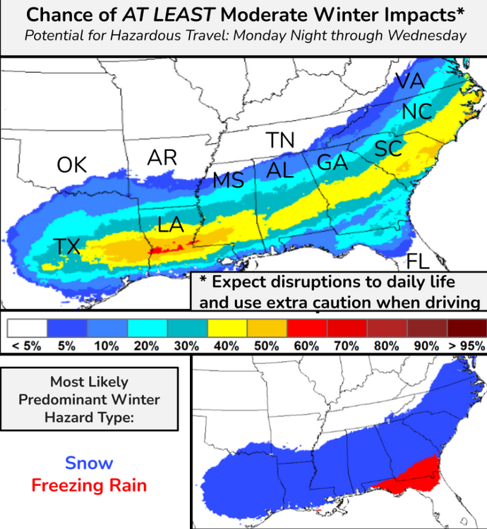
This is always a good look when MRX refuses to include the southern Valley but north Ga is included so everyone is colored in on the map with a hole for the southern valley. It looks very strange on a map.
-
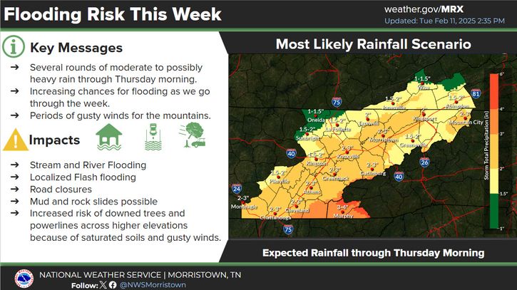
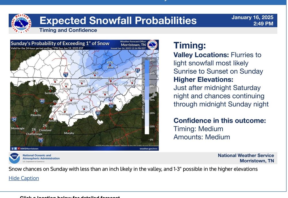
MRX keeps knocking back the totals they see for the valley. Did have knoxville at 6 to 8 inches. now just 2 to 3. With the dryness that we have had this does not seem to be much of a deal. .
-
Here in West Knoxville my temp has dropped fast. Even under cloud cover I went from 51 to 42 in the last 3 hours. Don't know if it will be enough but I am surprised. I am sure north of us and with a little elevation things should stick with any rates.
-
Just had 30 dBZ returns pass over the house and nothing falling. I am just a 1020 feet. Got some dry air.
-
This is the craziest thing I have ever seen, There is a snow hurricane in Pensacola Beach. There is also even heavier returns out in the gulf about to come ashore. https://hiltonpensacolabeach.com/beach-cam/. If you look close you can see the resort pools are starting to freeze over.
-
Here is one more link. Bourbon St New Orleans. Incredible! https://www.earthcam.com/usa/louisiana/neworleans/bourbonstreet/?cam=bourbonstreet#google_vignette
-
https://www.brproud.com/news/local-news/east-baton-rouge-parish/skycam-tracks-snowfall-in-east-baton-rouge-parish/ here is a live link Almost zero visibility. Click on and wait a few seconds will come up at top of page.
-
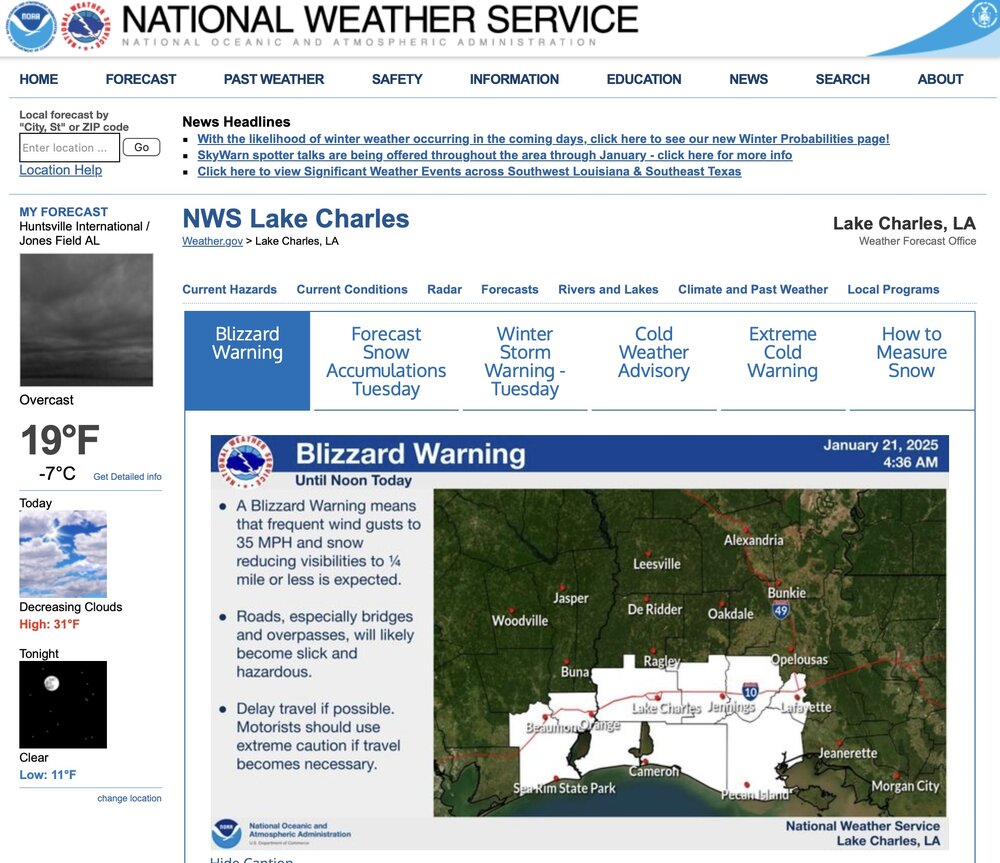
This is just Historic Blizzard warnings on the gulf coast.
-
 Our ground has turned white here in West Knoxville and the roads are getting a white glaze on them. If Temps drop fast and this continues much longer there will be problems. Snowing harder now than I have seen it all day.
- 207 replies
-
- 4
-

-
- obs
- light snow
- (and 2 more)
-
Just went through Sevierville and they have around 2 inches on the ground in the downtown area. Roads are starting to get icy and snow covered. Coming down good at the moment.
- 207 replies
-
- 2
-
-
- obs
- light snow
- (and 2 more)
-
We have switched to all snow in West Knoxville Temp is now down to 33 at my house and we have a light dusting. It is coming down at a good clip.
- 207 replies
-
- 6
-
-
- obs
- light snow
- (and 2 more)
-
Send some of that down in the valley. Sometimes that happens when we get these Arctic fronts. Oh Never mind. It is here in the form of a hard sleet shower. If we can keep the moisture we are now in business.
- 207 replies
-
- 3
-
-
- obs
- light snow
- (and 2 more)
-
Notice the almost due East-West line that cuts off Knox county right at the county line. No disruption of daily life for any Knoxvillain.

- 207 replies
-
- 6
-

-
-
- obs
- light snow
- (and 2 more)
-
Always have to have the cutout for less snow totals for Knox county. Don't want to have to many people getting excited. Brings to much attention. I will be happy if we get an inch. Happier if it over performs. I have now had more than an inch of snow in my front yard for an entire week. That is very rare.
- 207 replies
-
- 2
-
-
- obs
- light snow
- (and 2 more)
-
Yeh, I don't buy it. I think there is going to be some very disappointed people in the deep south. I would like them to score but many times these setups say snow and that far south they end up with ice. Like you say our temps don't add up to what is being forecast. We will see.
-
MRX not sounding very excited about probability with Sunday Snow
-
That is the way I remember it. I think they are talking about averages.
-
The new afternoon MRX disco discounts snow chances as well. For the early part of next week, the main weather impact will be extreme cold temperatures, driven by an Arctic High originating in northern Canada. Current model guidance indicates this high to remain very strong (near 1045mb) and gradually become centered over the area. Very deep troughing and 850mb temperatures nearing -20 Celsius will near record low values for this time of year. Confidence is fairly high for most places to see highs in the 20s Monday and Tuesday, possibly even in the teens. The strength of subsidence and CAA also make the case for many places to drop into the single digits, despite a lack of predicted snow cover. At this range, it is unclear how much wind may result, but wind chills could easily reach Cold Weather Advisory criteria. Past climate data shows that temperatures this cold only happen about once every 2 to 3 years in the area. The other question will be if any system develop and track close to our area next week. Based on current model data and the strength of the Arctic High, potential is fairly limited, but this is still a possibility.
-
Nothing like remembering old friends and good times.
-
How many times has similar things happened. Just saying. This could be the exception.
-
I remember listening to the Weekend Met for News Channel 9 out of Chattanooga on the Sunday evening, almost a full week out from the storm of 93 that would start the next Friday evening. He was honking the first warnings about the potential of a multi inch system. I remember thinking how odd it was that he was speaking so confidently about a system so far out and talking about it being several inches. It was also strange to me because it had been so warm and late in the season. I had just come out of the Garden tending my Broccoli that was the size of dinner plates.
-
I have thought the exact same thing at times about the "Young night shift". Could be.


