MJOatleast7
-
Posts
333 -
Joined
-
Last visited
Content Type
Profiles
Blogs
Forums
American Weather
Media Demo
Store
Gallery
Everything posted by MJOatleast7
-
Even in the lackluster '80s, weren't the Januarys of '86 and '87 both prolific (BOS around 24" both years)? Those helped mitigate the general ratter-ness going on then
-
FWIW, this eruption released less ash and SO2 than even St. Helens in 1980, let alone Pinatubo in 1991. Its effect on the climate is probably far less that we saw in 1992 with Pinatubo. Also, volcanoes that erupt in the tropics (e.g. Tonga) tend to result in +NAOs and warming, at least for the first 9 months or so, before any cooling sets in. That said, I'm not sure what difference a winter-erupting volcano would make, as opposed to the summer eruption of Pinatubo, whose cooling was not apparent here until the following March.
-
Like the drunk guy in the Wedding Singer.

-
One bit of solace...next week's rainer to Quebec City now shows ice just north of LCI. A lot colder.
-
You and Cantore can room together.
-
Winter’s back will break, according to Old Farmer’s Almanac (on Feb. 18) of course, that requires winter to actually HAVE a backbone in the first place…
-
Yeah, about 9 months of +AO resulted from that. IIRC, Then it flipped suddenly in March of 1992. BOS actually got more snow that season AFTER the vernal equinox than before. Then we hit the bonanza winters of 92-93, 93-94 and 95-96. two things, though: Pinatubo was a much larger eruption than this one in terms of plume altitude and volume ejected (unless we get subsequent eruptions) and I’m not sure if even a larger eruption would be enough to flip the ENSO state.
-
Ash and SO2 eventually have a net cooling effect, but it’s a tropical volcano, which tends to give us 9-12 months of +NAO at the beginning. Also don’t know how much particulates have been ejected. Will also depend on any future eruptions, obviously.
-
-
There goes the futility title for this year. (1936-37 BOS)
-
December 2021 Obs/Disco...Dreaming of a White-Weenie Xmas
MJOatleast7 replied to 40/70 Benchmark's topic in New England

-
So when does he start predicting a Venus climate here?
-
December 2021 Obs/Disco...Dreaming of a White-Weenie Xmas
MJOatleast7 replied to 40/70 Benchmark's topic in New England
The issue here is the SE ridge and all the velocity it's creating as the flow tries to bump up against it and gets compressed. We've seen it so many times, it's endemic in this fast-flow environment, especially in a Nina. It can't dig enough. -
December 2021 Obs/Disco...Dreaming of a White-Weenie Xmas
MJOatleast7 replied to 40/70 Benchmark's topic in New England
They desperately need it actually… -
December 2021 Obs/Disco...Dreaming of a White-Weenie Xmas
MJOatleast7 replied to 40/70 Benchmark's topic in New England
Where is this from, Aomori Snow Corridor? -
December 2021 Obs/Disco...Dreaming of a White-Weenie Xmas
MJOatleast7 replied to 40/70 Benchmark's topic in New England
So congrats Sukayu Onsen? Sent from my iPad using Tapatalk -
December 2021 Obs/Disco...Dreaming of a White-Weenie Xmas
MJOatleast7 replied to 40/70 Benchmark's topic in New England
Snow crystals slamming against each other is the leading theory of how thunderstorms get electrified. -
Yup - shift everything 200 nmi east and we’re good. Also would help to have a 50/50 low to lock in cold air. But maybe that doesn’t normally show up yet anyway. Any correlations that anyone has noticed between 50/50 lows and ENSO state? .
-
Hingham also has a orientation issue - it’s on an east-west oriented stretch with water to the north. So even a NNE or N wind, which would give most everybody else a shot at holding on to some cold, has too much overwater fetch to make it work. Granted, it’s mainly just Boston Harbor we’re talking about, but especially early in the season, it mixed in too much heat content at lower levels. .
-
The time of year too - this time of year the sun is always below the maximum 42 degrees elevation, so the rainbow is visible all day. The farther away from noon it is, the more rainbow is visible. .
-
We're still temporally near the minimum of the cycle even though getting some active sunspots. I think we're still good even with the recent spike given the historically low background state of this cycle. Also, the low but ascending part of the cycle generally seems to do better than the descending part anyways (unless you're near the 11-year peak)
-
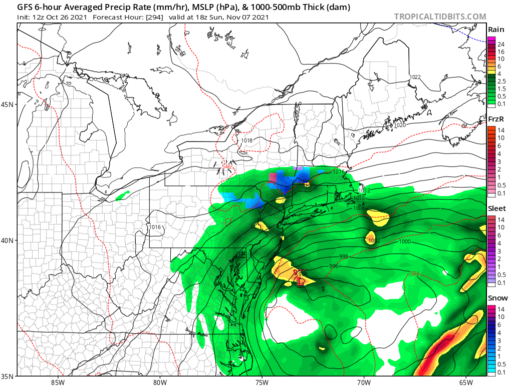
Potential Major Noreaster 10-26 through 10-27
MJOatleast7 replied to ineedsnow's topic in New England
Simple momentum transfer from the falling rain would make one think so. -
Potential Major Noreaster 10-26 through 10-27
MJOatleast7 replied to ineedsnow's topic in New England
I had read something, years ago, that suggested that...anthropomorphizing as it may be, the atmosphere has to "learn" how to storm after long periods with no synoptic storms (e.g. summer). That once it had done it one time, something in the atmosphere had "learned" something and was primed to do it more easily the next time. Tip, any thoughts? -
Potential Major Noreaster 10-26 through 10-27
MJOatleast7 replied to ineedsnow's topic in New England
So...we do it again a week from Sunday?