

GrandmasterB
-
Posts
634 -
Joined
-
Last visited
Content Type
Profiles
Blogs
Forums
American Weather
Media Demo
Store
Gallery
Everything posted by GrandmasterB
-

The Ides of March end of Winter 2023
GrandmasterB replied to paweather's topic in Upstate New York/Pennsylvania
It’s reassuring to know that if any model spits out 30” in our general area, Blizz will be posting it. That’s world class consistency! -
Central PA Winter 2022/2023
GrandmasterB replied to Blizzard of 93's topic in Upstate New York/Pennsylvania
50/50 snow sleet mix. Mulch covered and grass starting to cave. Would love for this to continue until that really heavy stuff out west gets here. -
Central PA Winter 2022/2023
GrandmasterB replied to Blizzard of 93's topic in Upstate New York/Pennsylvania
I’m lazy, post maps -
Central PA Winter 2022/2023
GrandmasterB replied to Blizzard of 93's topic in Upstate New York/Pennsylvania
Fatties mixed in now too. I’m considering this a huge win (for this winter). Don’t even care if it flips to rain the rest of the way. -
Central PA Winter 2022/2023
GrandmasterB replied to Blizzard of 93's topic in Upstate New York/Pennsylvania
Very surprising considering the globals didn’t really move the rain/snow line too far north throughout the storm. Actually dip it south at the end so will be interesting to see how this happens. -
Central PA Winter 2022/2023
GrandmasterB replied to Blizzard of 93's topic in Upstate New York/Pennsylvania
Yeah, mostly sleet here with even a little accum starting. Temp has dropped quite a bit with dew point probably close to 32. -
Central PA Winter 2022/2023
GrandmasterB replied to Blizzard of 93's topic in Upstate New York/Pennsylvania
Now this is more like it! -
Central PA Winter 2022/2023
GrandmasterB replied to Blizzard of 93's topic in Upstate New York/Pennsylvania
And then Euro is “right where we want it range” for next weekend and still crickets in here. It’s not even March yet weenies, get your heads in the game!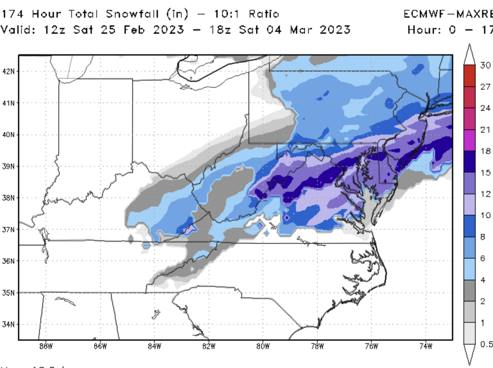
-
Central PA Winter 2022/2023
GrandmasterB replied to Blizzard of 93's topic in Upstate New York/Pennsylvania
Euro kinda interesting for Monday now. This has shifted quite a bit south over the last 48 hours.
-
Central PA Winter 2022/2023
GrandmasterB replied to Blizzard of 93's topic in Upstate New York/Pennsylvania
Happy hour GFS doing its thing! The clown map is funny because it gives Harrisburg a 6 hour panel of sleet that accumulates 16”. -
Central PA Winter 2022/2023
GrandmasterB replied to Blizzard of 93's topic in Upstate New York/Pennsylvania
Guilty. Unfortunately “getting real” this season is a Hail Mary, making its own cold air, needs a perfect track, thread the needle, gone tomorrow, 120 hour model fantasy storm. -
Central PA Winter 2022/2023
GrandmasterB replied to Blizzard of 93's topic in Upstate New York/Pennsylvania
The individual 12Z EPS members are intriguing. Some decent hits in there. -
Central PA Winter 2022/2023
GrandmasterB replied to Blizzard of 93's topic in Upstate New York/Pennsylvania
I like rolling the dice with a well defined boundary to our south. Often times we get multiple chances and some of them can be significant. Might also see a cutter that hits a deeper cold airmass than what we had yesterday leading to a better front end thump. There are still ways to fail of course but that’s the case in every pattern. -
Central PA Winter 2022/2023
GrandmasterB replied to Blizzard of 93's topic in Upstate New York/Pennsylvania
I just measured 2.25” on the sidewalk. Light precip that’s mostly sleet now with a few flakes mixed in. Temp hovering at 33. If it fails to rain here that would be an incredible positive bust. -
Central PA Winter 2022/2023
GrandmasterB replied to Blizzard of 93's topic in Upstate New York/Pennsylvania
Yeah, I was comparing GFS to everything else. Euro may have been 2nd closest. NAM and RGEM did poorly. And I’m only grading my hood. I’m selfish like that! -
Central PA Winter 2022/2023
GrandmasterB replied to Blizzard of 93's topic in Upstate New York/Pennsylvania
Back to all snow. With over 2” I’m going with positive bust here. You love to see it! -
Central PA Winter 2022/2023
GrandmasterB replied to Blizzard of 93's topic in Upstate New York/Pennsylvania
Close to 2” here with 80/20 snow sleet mix. GFS did very well with this storm. -
Central PA Winter 2022/2023
GrandmasterB replied to Blizzard of 93's topic in Upstate New York/Pennsylvania
Well that escalated quickly! Mod snow here. Let’s see how long it holds on. -
Central PA Winter 2022/2023
GrandmasterB replied to Blizzard of 93's topic in Upstate New York/Pennsylvania
4” in two hours on the RGEM. I’d pay cash for that! -
Central PA Winter 2022/2023
GrandmasterB replied to Blizzard of 93's topic in Upstate New York/Pennsylvania
The 10:1 on TT looks even better. It’s probably clown but interesting nonetheless. Areas that can stay snow for an hour or two could do ok. -
Central PA Winter 2022/2023
GrandmasterB replied to Blizzard of 93's topic in Upstate New York/Pennsylvania
GFS will not give it up. Continues to show more snow than any other model. I’m assuming it goes down in flames. -
Central PA Winter 2022/2023
GrandmasterB replied to Blizzard of 93's topic in Upstate New York/Pennsylvania
The NAM is concerning even for State College. I think that's probably curtains for down here. Really the theme of the season, just can't get anything to work. -
Central PA Winter 2022/2023
GrandmasterB replied to Blizzard of 93's topic in Upstate New York/Pennsylvania
It looks like hour 68 is available on weather.us so I compared the total snow accum map from 0Z and it’s noticeably crappier. IDK if it’s valid or not but it would make sense if it were indeed way crappier. -
Central PA Winter 2022/2023
GrandmasterB replied to Blizzard of 93's topic in Upstate New York/Pennsylvania
Oh, for sure! Very valid concern. There is a straight forward case to make that the morning marches on and temps rise before the precip even gets here. I’ll offer that it’s a 30% chance that it’s plain rain at 33 by the time it gets here and I don’t even see a flake. -
Central PA Winter 2022/2023
GrandmasterB replied to Blizzard of 93's topic in Upstate New York/Pennsylvania
Elliot’s forecast looks reasonable to me and closely matches NWS here. I also think the concerns everyone laid out this morning are valid and warranted. However, I also think this set-up has a better “positive bust” potential than any of our previous chances so far here in the southeast. The temps and especially DP leading in aren’t bad. GFS just went colder at 12Z and NAM has DP’s in the mid 20’s tomorrow morning. This should basically be a wall of precip with little virga so if we can squeak out an extra hour of snow we could get to 2” or maybe a bit more. Again, forecast wise I think up to an inch is a prudent forecast. But I can see a path to exceeding that if it breaks right which I really haven’t seen in past chances.

