

GrandmasterB
-
Posts
634 -
Joined
-
Last visited
Content Type
Profiles
Blogs
Forums
American Weather
Media Demo
Store
Gallery
Everything posted by GrandmasterB
-
Yeah, that’s a bit of a different evolution per the GFS. I think I prefer this outcome since it would leave a lot of us with some additional wiggle room if it comes more northwest within the last 48 hours.
-
Too close for comfort down here with 4 days left to go. For MBY I’d like to see the stronger primary/less confluence trend reverse tonight or tomorrow or we’re in trouble.
-
Rest up everyone, starting tomorrow we can start to over analyze the NAM!
-
I’m fine with a region wide 6-12 and then if we get some rainers so be it. It’s been too long to be picky!
-
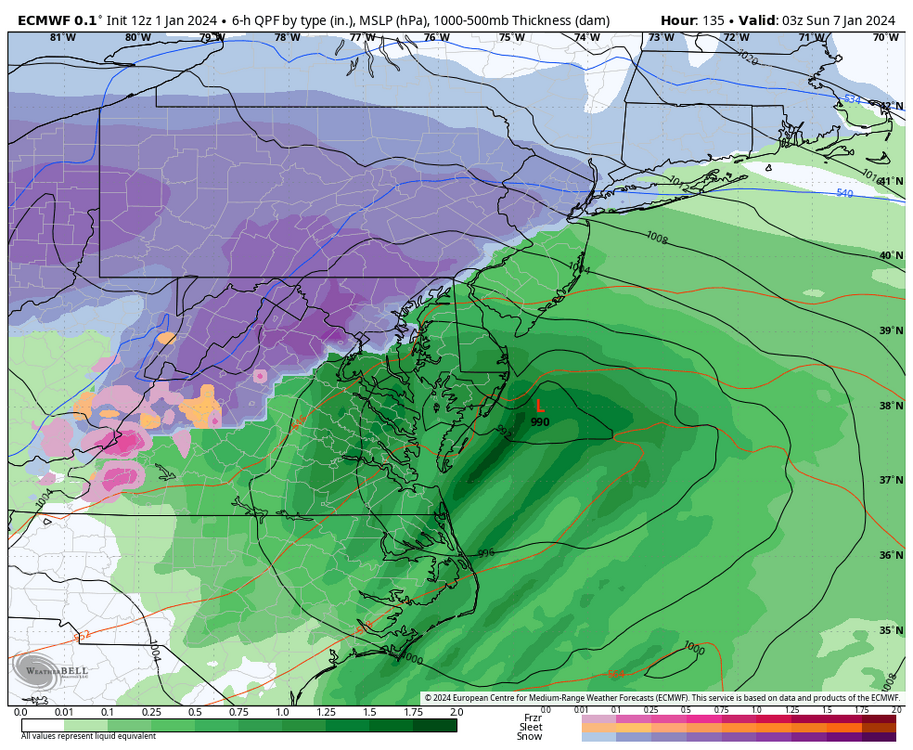
Southern stream should be plenty juiced too. QPF isn’t well modeled 100+ out, assuming that track we could see some of those higher end amounts. It’s not a slow mover but should be plenty dynamic.
-
High is a touch stronger. Beat down incoming at 132.
-
Looks like it’s going to be a big hit
-
Primary hangs on a bit too long, otherwise it’s damn near classic.
-
-
LOL, just messing around. It’s a big euro run for all of us and mitchnick has done PBP in the past so I thought it was fitting.
-
Biggest Euro run of mitchnick’s life coming up.
-
GEFS is sick. This was posted a few minutes ago by Millville in MA and I mentioned this yesterday. Get a strong high and even if the inland runner scenario happens we’d still get thumped. “This was what I wanted to see. A better in-situ signature on the lead will work wonders for the initial precip, as well as maintaining a decent PBL profile during any storm height. There's some serious members too on that high. Saw some 1035mb or so readings when looking at the member plots. Great to see.”
-
Keep us posted!
-
Typical swings at 120+ hours out and 30 model runs per day. A blend of all the 12Z guidance thus far would be fine for us.
-
Impressive 6Z euro output. My goodness.
-
Would love to see that High continue to strengthen that way even if the primary goes further north we still get a thump.
-
Thanks for the PBP mitchnick! As others have stated, long way to go on this one but at least we should have a few days of tracking.
-
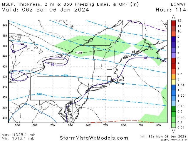
I’d buy that look right now for Jan 04. I get surface temps are iffy, but with that track central would be in the game. It’s not like the low is plowing up into Philly, if the track is offshore 50 miles I like our chances for some snow. Also, as Blizz is pointing out maybe multiple chances too. Great runs overnight.
-
Unreal
-
Nice to see some threats popping up now on the operational runs. Hopefully we start tracking some storms within the 5-7 day range!
-
Very few silver linings to no snow…but one is definitely the meltdowns in the New England forum.
-
Sorry I only pay attention during the winter…did our region have to give anything up to get mitchnick? I thought mitchnick only posted in mid-Atlantic. Great addition for this sub forum.
-
It was great for Lancaster and a few other spots to really cash in on an overperformer yesterday. I never tracked that event and got 4 hours of light snow that accumulated on grass and even some paved spots. Could already rank this year ahead of last year!
-
We all know the deal with these post frontal systems. Cold air usually takes longer to come in than modeled. West winds cut the precip off quickly east of the mountains. Set low expectations.
-

Central PA Autumn 2023
GrandmasterB replied to Itstrainingtime's topic in Upstate New York/Pennsylvania
Low probability next week (obviously) but I believe this should kick off tracking season in earnest. Feels good to be back. Can’t be as bad as last year, right? RIGHT??


