Jns2183
-
Posts
4,747 -
Joined
-
Last visited
Content Type
Profiles
Blogs
Forums
American Weather
Media Demo
Store
Gallery
Everything posted by Jns2183
-
This storm looked like a nothing burger for days. It was this past Thursday's storm only drier. We have had so many short term models fall on their face in the spring and summer this year we would refuse to believe any rain would occur when we had 70% plus chances. The other side of that I discovered were these areas with a 10% ending up with deluges from the blue. Let's cheer for nature giving us many changes for randomness to occur Sent from my SM-G970U1 using Tapatalk
-
Honestly on the pure potential available in this pattern, with no post hoc rationalizing lucky scores I will take this February setup probably more than any other one since 2010, maybe before. 3.5" of qpf from 5 storm systems in 16 days with 80% of the time below freezing and highest temp basically 45-50 in Harrisburg for a few hours overnight before crashing hard due to a low bombing out by buffalo before realizing he went wrong way somehow appears off cape code 3 hours later. There is just so much opportunity with the quantity of systems, moisture, boundary position and oscillating, temperature profiles. With so many moving parts coming so often I'll take my chances at being lucky since a small scale chance e in some overlooked region can drastically alter our events without warning Let us remember back to our ultimate lucky moon shot in 2016 that although we we stocked at the crazy high numbers the models kept putting out, the whole weather community basically automatically cut everything in half if and called it a 1% Highend possibly. It had seemed to happen to other locals that whole winter and apartment row before that. So much so that the Ctp discussion 5 days before mentioned medium confidence in a 8-12" forcast. Here is horst probabilities 4 days before: January 19, 2006 Here's my "probabilistic forecast" for LanCo--accounts for various uncertainties: 20% chc of I believe 12-16" was forecast as snow began that evening. Pittsburgh people came over saying the waa hit like freight train. @Bubbler86 told everyone in a remark that he probably was laughing at for typing such absurdities that in 2 hours from 12-1 the HRRR was pasting the southern counties and lsv in something like 4-6" of snow in an hour due to waa. In the grisp of all our weenie fever we thought it was absurd. An inch maybe two an hour is damn near the limit for waa we figured, then 4"+ verified all over. I think I got up at 6am with 14" on the ground ecstatic because I figured we get hit 20" maybe 24". A couple hours later that route 81 deathband gave me 16" more in 4 hours with a few hours of moderate snow giving me a few more. I had thought nothing could top overshooting the high end snowfall forecast for all 3 storms in winter of 2010, but that did it. They all had last second changes that gave us winning lottery tickets. Each and every storm we have a chance at is another chance at one of those tickets hitting again Sent from my SM-G970U1 using Tapatalk
-
I remember seeing a retired nws employee who had spent his whole career in the guts of their model explain the 1993 model coup in these terms: On small scales in closed systems watching them hit some kind tipping point where the end result Is certain is just how we've done science experiments forever. A point is reached where are you 100% know happen in a week unless some force outside the closed system acts upon it even though it will continue looking calm till almost the very end. We could hit a 50% verification wait for many things and I'll models even hours into the future. So what occurred to me was what kind of ungodly force is this thing going to be that it seemed more akin to end result of a city when Godzilla shows up in a movie than to any weather phenomenon I saw in my whole career before or after. Except he said it in a much more funny and illuminating manner Sent from my SM-G970U1 using Tapatalk
-
What I would give to find access to the text output of the 15 daily snow totals of each ensemble for each run for last 7 days. Can you post the qbf totals for each ensemble at runs end? For us at least I think 35%, maybe more of those totals come Wednesday storm on there. Sent from my SM-G970U1 using Tapatalk
-
That tuesday-wednesday time frame has been one of more impressive signals I've ever seen just do the fact it hasn't budged really from OP and ensemble models for last 5 maybe 6 days. Knock on wood it comes through as modeled in 4 days it would have given weenies 40 straight model runs of pleasure. On a side note, I remember reading that the signal for the blizzard of 93 being a crazy HECS on all the models came so early was so off the charts in strength, and consistency that the scientists in charge of physics and mathematics of the models thought a fundamental error in the basic weather physics formula was the cause for a couple days cause for a couple days leading to a panicked goose hunt to locate it Sent from my SM-G970U1 using Tapatalk
-
I would love to see the close up snow amounts for the ensembles for this upcoming Sunday, Thursday, then normal end of run ones. A strong signal is definitely there. I just wonder how much of the end of run totals are due to Wednesday storm which has been pretty consistent over multiple runs of all the models. It seems almost that with so damn much QPF headed this way each ensemble got to there amounts differently each run, but that bit of uncertainty was masked somewhat by the final totals being somewhat consistent. Who knows. It all may work out just due to how many chances keep getting thrown to us. I'm very confident in a nice moderate snowfall Tuesday to Wednesday. I'm praying the system after that doesn't bull rush lake Erie sending 60s to Massachusetts and 1.5" to 2" of rain to entire east coast. Euro had the snow from that pretty much confined to Toronto and West. That was the hecs the GFS lost. Sent from my SM-G970U1 using Tapatalk
-
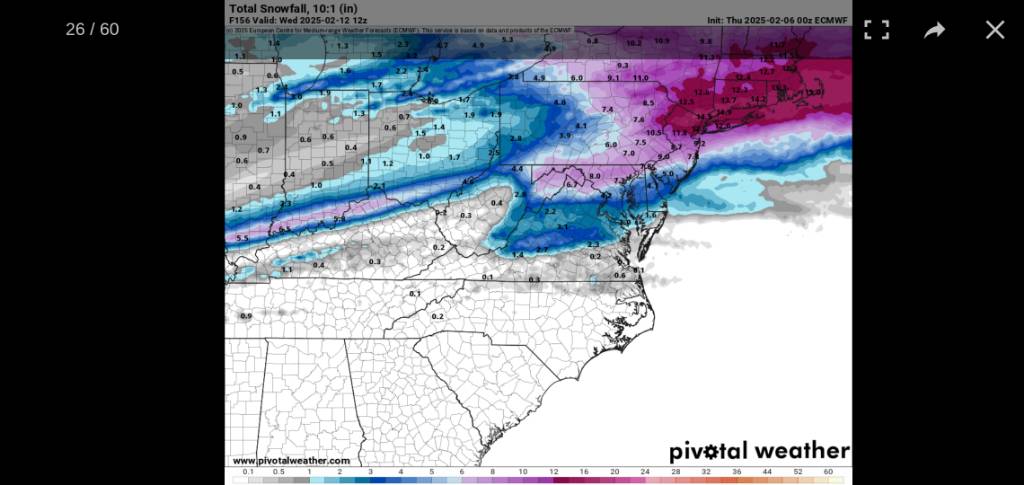
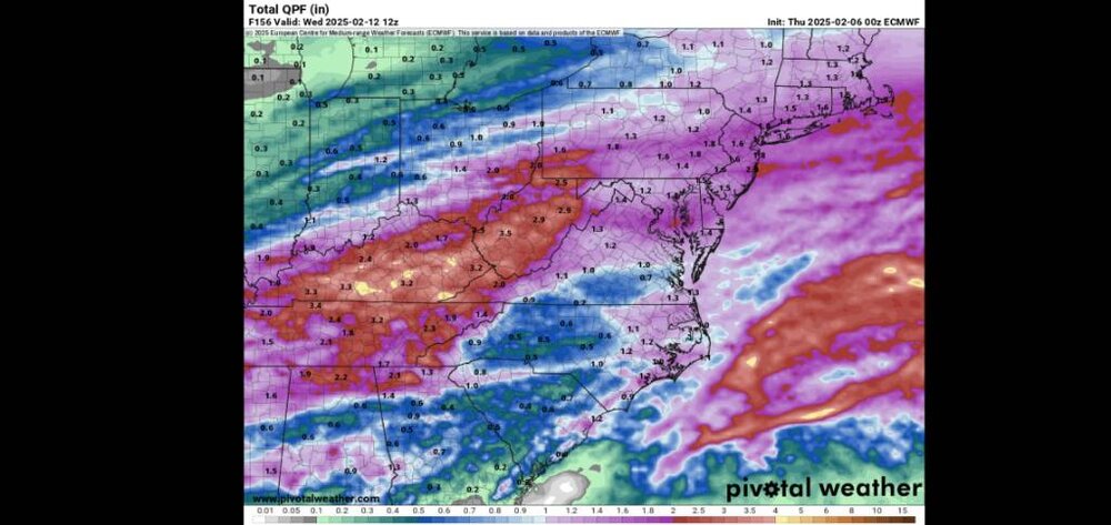
At 12z on Wednesday 2/12 we are sitting at 6" of snow on 1.6" QPF At 0z on Friday 2/21 we are at 6.1" of snow on 3.7" QPF Haha, what's even worse is that those 2 dates are 204 hours apart. We are forecast to be below freezing 171 of those hours or more than 80%. That model run was pure nightmare fuel Sent from my SM-G970U1 using Tapatalk

-
Yes, but after Tuesday it wants to drive the low Thursday/Friday up to Buffalo which screws the pooch on the boundary. Using 10-1 ratios it gives me 4.2" by 6z Wednesday 2/12 (hr 126 on the Oz) 4.9" by 6z Wednesday 2/19 (hr 296). So less than 1" in 7 days between. Looking at total snowfall by 6z Wednesday 2/12 & 2/19 it's easy to calculate that's week snowfall over time. here are previous runs with associated total 10:1 snowfall 04/12z. 5.5". 8.2" 05/00z 15.6" 22.6" 05/12z 8.1 10.8" 06/00z 5.9" 6.1" 06/12z 2.9". 3.4" 07/00z 4.2" 4.9" A quick look at the GFS total snow for Wednesday 2/19 at 6z has been consistent at close to 6" on 1.2" qpf till then. The issue with 0z once more it snows 1" more the next 8 days. Oh we get 1.5"-2" of qpf in those days just it's all a mix or rain. The GFS seems to have heaviest snow Tuesday and Wednesday around Richmond at times. The ensembles have been amazing for all 3 big models. But after seeing the euro now trying to drag 60s to almost Boston Sunday, getting Lancaster to mid 50s while sending the low West of Pittsburgh I can see how this whole thing can go wrong. I give it even odds kmdt sees 10" total for February Sent from my SM-G970U1 using Tapatalk
-
I don't know how it's in mount joy, but the Cumberland valley, especially 10 miles or less from Susquehanna almost always have significant issues getting out cold. As for issues with thermals,we basically follow everyone else Sent from my SM-G970U1 using Tapatalk
-
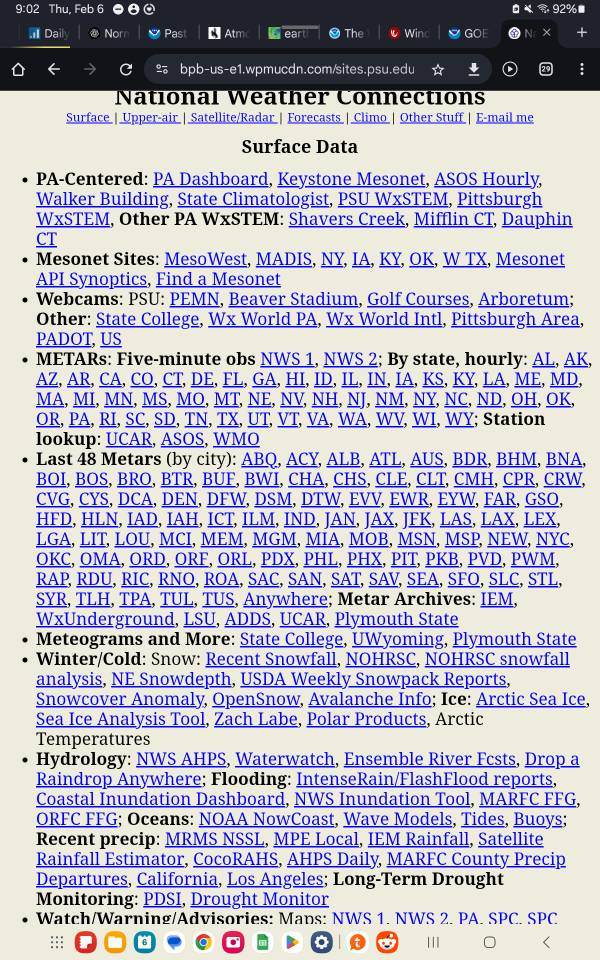
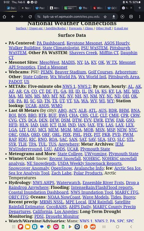
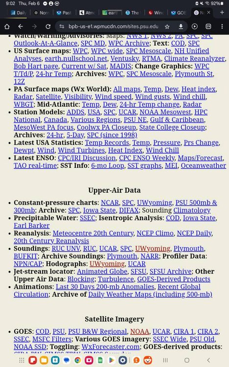
So I someone just wandered onto this amazing weather links page that Jon Nese, the Penn State University associate chair for the undergrad department of meteorology, kept in pretty much the same format from the 90s when I'm guessing it was first put online. It's organization is incredible and the overall depth is as well. It scrolls down like the equivalent of 10 pages deep in today's website design. Regardless I found like five or six very interesting tools all focused on the upcoming winter weather that I never knew existed in a couple minutes of looking at the page. https://bpb-us-e1.wpmucdn.com/sites.psu.edu/dist/a/111486/files/2023/07/natlwx.htm Sent from my SM-X210 using Tapatalk
-
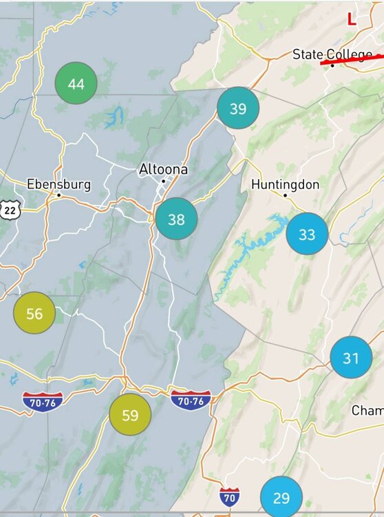
Pittsburgh is in the middle of a weird weather night. That lightning definitely held together and here's a quick dirty local lightning map for last 30 min. So 230-300am. That said the airport and points downtown are mostly between 30-34 degrees. The real funky temperatures are on the west side of Allegheny front with anyone from 1000' -1400' between 37-40. Anyway ne close by up above 1550' is still below freezing. Until you reach seven springs at 2700' and Somerset at 2300' and it's 28 there. And 29 at fort Hill at 3200 I'm just surprised there is a 5-10 degree difference for temperature for those below 1000' and above 1500' compared to that 400 foot high ribbon for those on the Allegheny ridge Sent from my SM-G970U1 using Tapatalk
-
I would think a wsw would be prudent Sent from my SM-G970U1 using Tapatalk
-
Question now is if its necessary Thursday to shovel an inch of concrete or if it will for sure all melt before refreeze Sent from my SM-G970U1 using Tapatalk
-
@MAG5035 had two great posts late night the last two nights that make me give credence to the sleet bomb angle above all. Sent from my SM-G970U1 using Tapatalk
-
Such a narrow streak of fluffy. It's going to suck watching it dump a mile away from the window as it throws me a pity flurry or two Sent from my SM-G970U1 using Tapatalk
-
Do schools go for the 2 hour delay or the full day close? I feel the 2 hour delay way too optimistic. I'm sure they will all just transition to online day and close. Sent from my SM-G970U1 using Tapatalk
-
This temperature gradient is something else Sent from my SM-G970U1 using Tapatalk
-
If there's a layer of sleet it will acreate Sent from my SM-G970U1 using Tapatalk
-
Most of it is occurring at night overnight Wednesday Sent from my SM-G970U1 using Tapatalk
-
Places in Japan just got 34" in 6 hours from a synoptic system bombing out. 40"-50" entire storm totals Sent from my SM-G970U1 using Tapatalk
-
It's that one two combo that can really cause havoc. It might be tougher freezing rain to accrete on asphalt at 30° but not on top of sleet. That's the recipe for a glacier Sent from my SM-G970U1 using Tapatalk
-
CAD Sent from my SM-G970U1 using Tapatalk
-
Next 24 hours will be like a yo-yo Sent from my SM-G970U1 using Tapatalk
-
Maybe he's resting up since he won't be sleeping much next week with 3 storms in 5 days Sent from my SM-G970U1 using Tapatalk
-
We haven't had a good true ice storm in forever here. I don't think this one will be a damaging one so I'm going to let myself get excited for it. Sent from my SM-G970U1 using Tapatalk