Jns2183
-
Posts
5,851 -
Joined
-
Last visited
Content Type
Profiles
Blogs
Forums
American Weather
Media Demo
Store
Gallery
Everything posted by Jns2183
-
People don't judge the weather April through October by the Min. Whether the public perceives those months as hot or cold by the max. November and March are a mix of max and min. December through February are judged by mins Sent from my SM-G970U using Tapatalk
-
It's this heavy mist/drizzle in downtown Harrisburg without a single return on radar. When's that Lancaster Doppler going to be up? Sent from my SM-G970U using Tapatalk
-
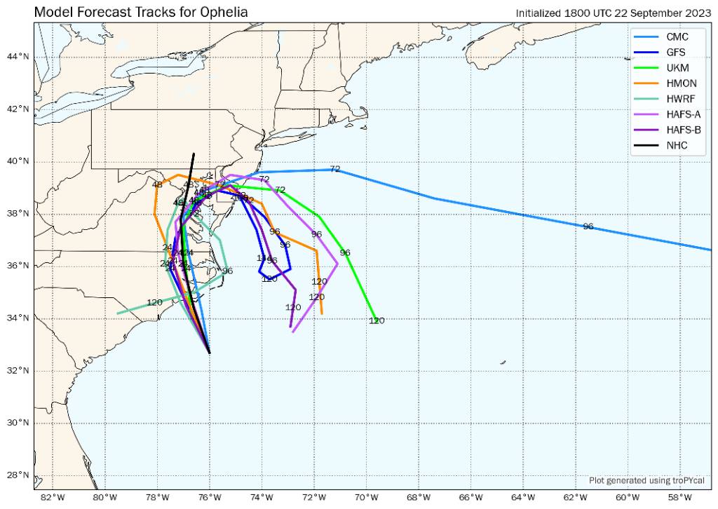
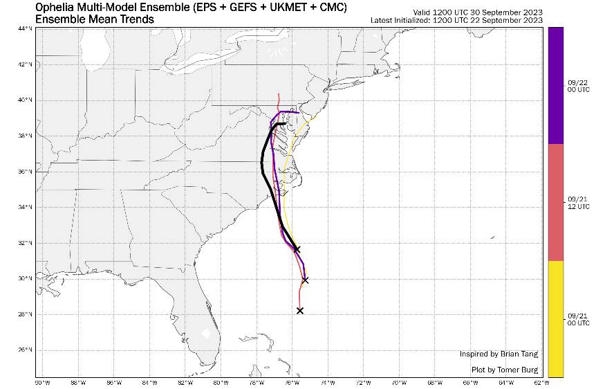
First picture is the 18z hurricane model tracks 2nd is a multi model mean (EPS + GEFS + UKMET + CMC). Yellow is 9/21 @0Z Red is 9/21 @12Z Purple is 9/22 @0Z Black is NWS forcast track Sent from my SM-G970U using Tapatalk

-
So current pressure is 986mb and dropping. Looking at mesos and model they all almost initiate and don't drop below 995mb. The NAM drops down to 989mb 8 hours from now. So what happens if this thing makes landfall in the upper 970's or low 980's, which now seems very very likely. That's a 15mb+ difference between ground truth vs models. It seems the the models with stronger LP drove in further west and were slower a day or two ago. Not sure if that still is the same. Regardless. These models are initiationing with pressure significantly higher than reality. Sent from my SM-G970U using Tapatalk
-
It keeps coming further north and west. I'm with @canderson buying wind being greater than forcast. Not sure up towards Harrisburg but definitely for southern Lancaster and York county Sent from my SM-G970U using Tapatalk
-
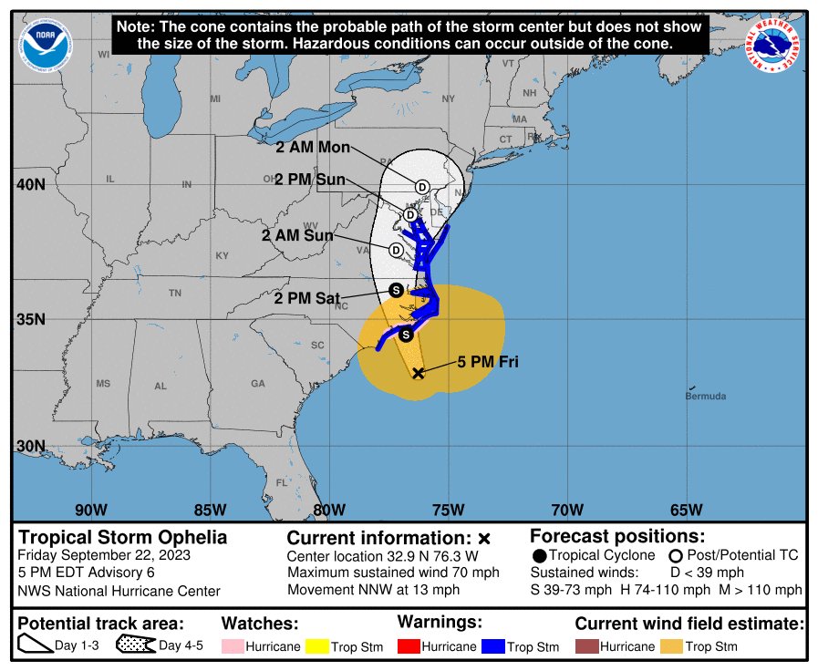
Boom Hurricane watch as of 5pm for NC Winds up to 70mph. Still has at least 12 - 18 hours over warm water Sent from my SM-G970U using Tapatalk
-
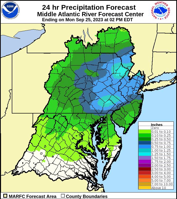
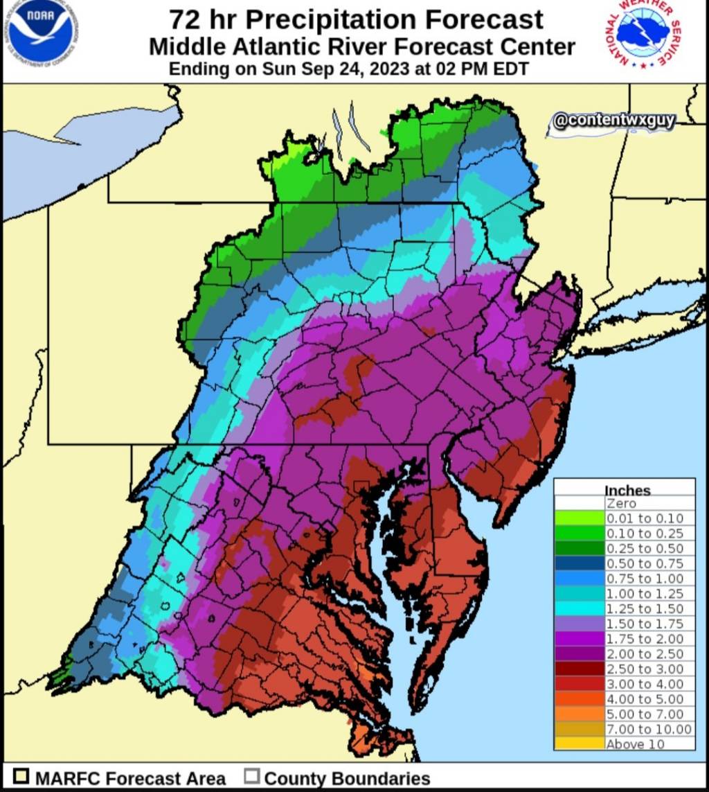
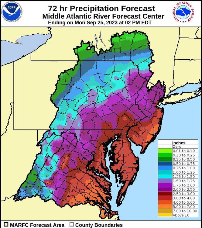
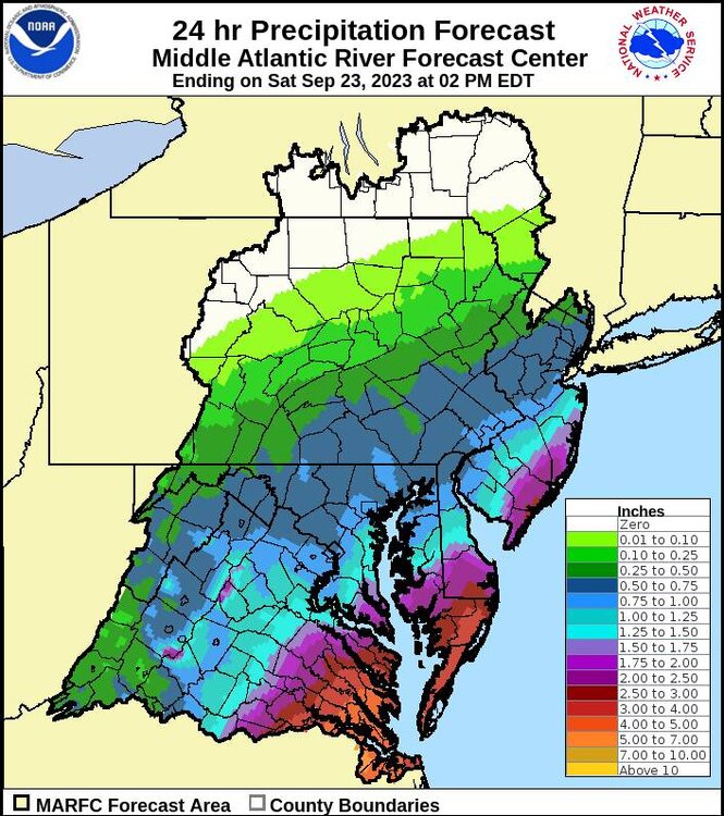
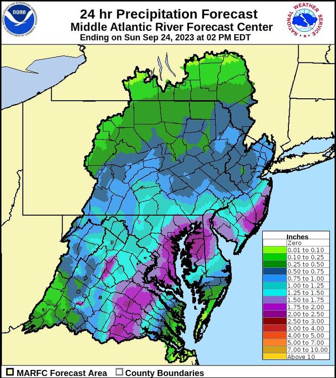
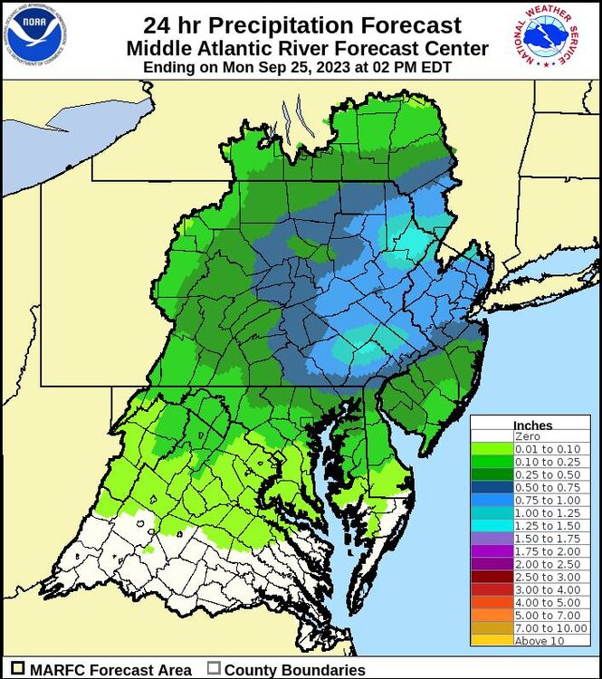
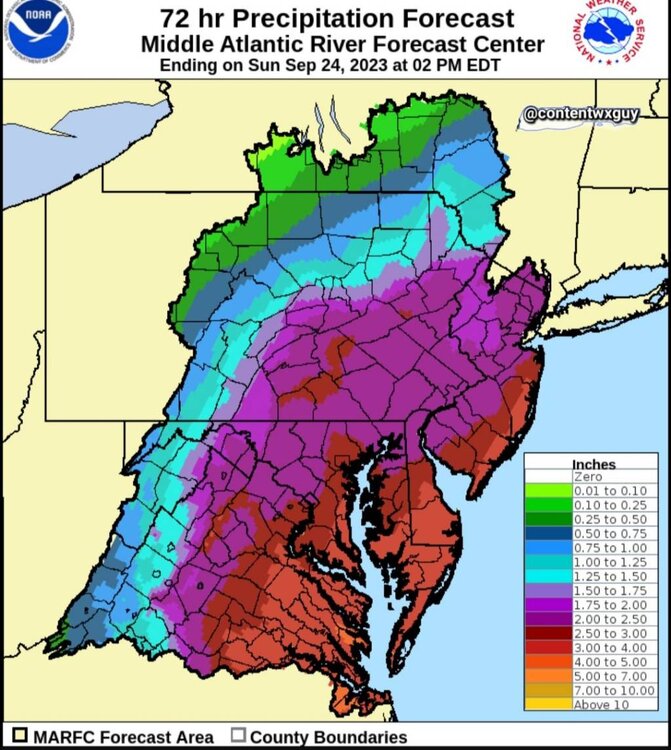
Long long duration event. Seems like nothing to crazy heavy, just 48-60 hours straight of light to moderate rain Sent from my SM-G970U using Tapatalk
-
This is going to make landfall stronger than anticipated Sent from my SM-G970U using Tapatalk
-
In memory of the soup nazi who gets to be the snow nazi this year! Sent from my SM-G970U using Tapatalk
-
I still see 2 inches next 72 hours in Harrisburg Sent from my SM-G970U using Tapatalk
-
Won't it have a lot to do with strength and position of high pressure Sent from my SM-G970U using Tapatalk
-
Fog for the win Sent from my SM-G970U using Tapatalk
-
God I miss these long duration storms Sent from my SM-G970U using Tapatalk
-
Looks like there might be a lull in the preceiptation that aligns quite well with game time Sent from my SM-G970U using Tapatalk
-
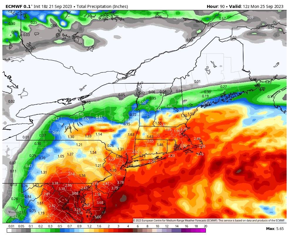
18z Euro Sent from my SM-G970U using Tapatalk

-
That's beautiful Sent from my SM-G970U using Tapatalk
-
@Bubbler86 Maybe its because your in OCMDbur I think up here the storm should be named after you. Sent from my SM-G970U using Tapatalk
-
I will say a prayer to weather gods to give a 968mb low at landfall via nam. Haha Sent from my SM-G970U using Tapatalk
-
Truthfully, this was best case for rain in my thinking. I knew models were trending towards that, but still. This was going all day n to the best rain case I could hope for the drought stricken LSV. Sent from my SM-G970U using Tapatalk
-
Wow that's a giant shift. Holy shit Sent from my SM-G970U using Tapatalk
-
Get there early and enjoy it. It's like nothing I've ever encountered in my 20 years of bartending. Sent from my SM-G970U using Tapatalk
-
I think route 81 may be again the dividing line between a washout and nuisance Sent from my SM-G970U using Tapatalk
-
A normal game is the equivalent to pounding some beers. A white out is like pounding shots of whiskey in between lines while listening to Metallica while 20 years old. Sent from my SM-G970U using Tapatalk
-
I first thought the weather might play into Iowa's favor by reducing crowd size and hampering offense. Now that I know no one of the 40 or so people I know are not going because of the weather and how the student section gets in bad weather, a long with the absolute fire in everyone's soul, along with the state of Iowa's offense; it seems the perfect environment for the defense to just t off on cade and take over the game. Sent from my SM-G970U using Tapatalk
-
I've been to 13. 2005 Ohio State is still by far my favorite. I think it was the loudest plus I only got tickets last second at the tailgate for cheap. They were 40 yard line with the old folks. I brought in two flasks started sharing, soon I swear every old guy pulled out their flask. Maybe it was because our state at halftime but those old bastards starting standing and cheering the 2nd half. Soon entire stadium was. It was the first time I in person ever saw the old rich folks with an energy to match the students. Never sat in such good seats since. Sent from my SM-G970U using Tapatalk