Jns2183
-
Posts
5,851 -
Joined
-
Last visited
Content Type
Profiles
Blogs
Forums
American Weather
Media Demo
Store
Gallery
Everything posted by Jns2183
-
That makes me question measurement methods as bubbler said. If Chester county is similar I'll buy that a demarcation line from hell set up over our forum for awhile. Sent from my SM-G970U using Tapatalk
-
1994 and 1996 were over 70" I believe Sent from my SM-G970U using Tapatalk
-
Compare that with the 70 years before to blow your mind even more Sent from my SM-G970U using Tapatalk
-
When I say the 1960s were insane I mean it. They literally had a +50% variance in decade average snowfall out of nowhere; forever tilting snow records so every year seems low. I can't find an anomaly so great in any other main weather variable over a decade. Sent from my SM-G970U using Tapatalk
-
If this is accurate thank God the Internet did not exist back then. The fair weather weenies on the forums would have rioted or jumped off a cliff Sent from my SM-G970U using Tapatalk
-
Do you have link to daily obs for those years Sent from my SM-G970U using Tapatalk
-
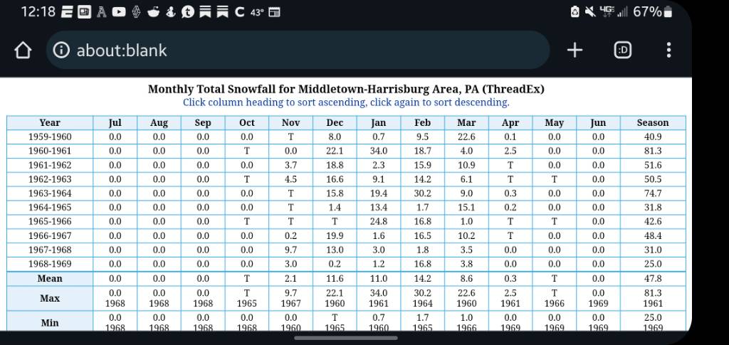
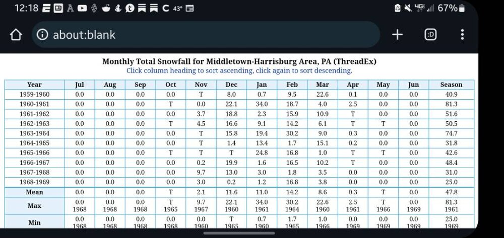
The Harrisburg results are certified. I'll have to look at Chester county later to compare Sent from my SM-G970U using Tapatalk
-
1961-1964 is insane. 20" less per year. Especially 62'&64'. Basically half of what Harrisburg got Sent from my SM-G970U using Tapatalk
-
Would love to see Lancaster data Sent from my SM-G970U using Tapatalk
-
Here you go to compare Sent from my SM-G970U using Tapatalk
-
Yes. Now KMDT was were KCXY is now back then Sent from my SM-G970U using Tapatalk
-
The 1960's we averaged 47". No other decade was more than 36" since 1890 besides the 60's. Figures it was that decade Sent from my SM-G970U using Tapatalk
-
People don't realize that from 1930-1960 we averaged 28" of snow a year From 1990-2020 we averaged 30" Sent from my SM-G970U using Tapatalk
-
Your true calling in life was to be a spokesman for the makers of Adderall Sent from my SM-G970U using Tapatalk
-
Id pay to see that actually. Sent from my SM-G970U using Tapatalk
-
Take that Phil!!! Sent from my SM-G970U using Tapatalk
-
Half those people there were sloshed Sent from my SM-G970U using Tapatalk
-
How does a mountain town in South central Italy hold the 24 hr snowfall record at 75.8"? Sent from my SM-G970U using Tapatalk
-
You're beating Boston Sent from my SM-G970U using Tapatalk
-
Minnesota.... ouch Sent from my SM-G970U using Tapatalk
-
Be happy you aren't a pirate fan Sent from my SM-G970U using Tapatalk
-
If it's dry all of Feb I can't even fathom the state of another forum Sent from my SM-G970U using Tapatalk
-
The CFS paints all of Feb as very very dry, as it has the trough axis too far east. Close enough where a couple of phases are certainly in the picture, but not a picture perfect pattern. Also the CFS has been horrid for awhile, even just 30 days in the future. In fact I think it's 90 day has been more accurate than it's 30 day. Sent from my SM-G970U using Tapatalk
-
Does that one mid Atlantic poster still collect weenie souls as the grim reaper Sent from my SM-G970U using Tapatalk
-
Just imagine how this forum will be after 10 days of mild, dry, boring weather Sent from my SM-G970U using Tapatalk