Natester
-
Posts
1,222 -
Joined
-
Last visited
Content Type
Profiles
Blogs
Forums
American Weather
Media Demo
Store
Gallery
Everything posted by Natester
-

Here comes winter -- October 28-November 1 Snowstorm Potential
Natester replied to Hoosier's topic in Lakes/Ohio Valley
18z GFS still holding on to the strong storm scenario while all the other models trended weaker. The 18z ICON only produces a couple inches in eastern Iowa. -
Here comes winter -- October 28-November 1 Snowstorm Potential
Natester replied to Hoosier's topic in Lakes/Ohio Valley
Yeah, since the snow in your area is most likely going to be of the wet type (early in the event). As for here, it'll be of the drier type, extremely rare for October. Multiple models has us below freezing for much of Thursday. The thing I was worried about concerning this upcoming winter storm is power outages, which doesn't seem likely since the winds won't be too strong and the temps will be below freezing. The vast majority of the trees around here still have leaves on them. Also, 12z ICON is faster with the system while the 00z Euro is slower. -
Here comes winter -- October 28-November 1 Snowstorm Potential
Natester replied to Hoosier's topic in Lakes/Ohio Valley
00z NAM 3k 10:1 snow accumulations has a more realistic scenario with widespread 1 to 2.5 inches of snow. EDIT: Hour 84 of the 00z NAM 12k is just like the 12z CMC. I highly doubt that will verify. -
Here comes winter -- October 28-November 1 Snowstorm Potential
Natester replied to Hoosier's topic in Lakes/Ohio Valley
00z HRRR 10:1 snow totals for tomorrow's snow looks nowhere near as impressive. Only a few areas reach 2 inches, with the exception of the Michigan pennesola. -
Here comes winter -- October 28-November 1 Snowstorm Potential
Natester replied to Hoosier's topic in Lakes/Ohio Valley
Models don't have Cedar Rapids getting above freezing on Thursday, which is a good thing because when temps are at 32F or above, the snow will cake on trees (especially with trees that still have their leaves) and cause tree damage, leading to power outages. Anyways, significant snow looks quite likely for Cedar Rapids on Thursday, first time since October 26, 1997, at least it won't be a very wet snow. Can't say the same for the onset of tomorrow's snow, though. -
Here comes winter -- October 28-November 1 Snowstorm Potential
Natester replied to Hoosier's topic in Lakes/Ohio Valley
I'm referring to the second storm. No change on the first snow system. -
Here comes winter -- October 28-November 1 Snowstorm Potential
Natester replied to Hoosier's topic in Lakes/Ohio Valley
12z GFS east and weaker. Caved in to the Euro. Also colder temps for Eastern Iowa during the second snowstorm, although the GFS still dumps over 6 inches here. -
Here comes winter -- October 28-November 1 Snowstorm Potential
Natester replied to Hoosier's topic in Lakes/Ohio Valley
Oh, I see. Well, the track is somewhat similar but the CMC is slower, having the snow shield track through on Friday November 1. -
Here comes winter -- October 28-November 1 Snowstorm Potential
Natester replied to Hoosier's topic in Lakes/Ohio Valley
First system or second system or both? -
Here comes winter -- October 28-November 1 Snowstorm Potential
Natester replied to Hoosier's topic in Lakes/Ohio Valley
Late next week's storm is basically a repeat of 1991, except further east and no ice. Winds gusts not to bad, although enough to aggravate snow stressed trees. -
Here comes winter -- October 28-November 1 Snowstorm Potential
Natester replied to Hoosier's topic in Lakes/Ohio Valley
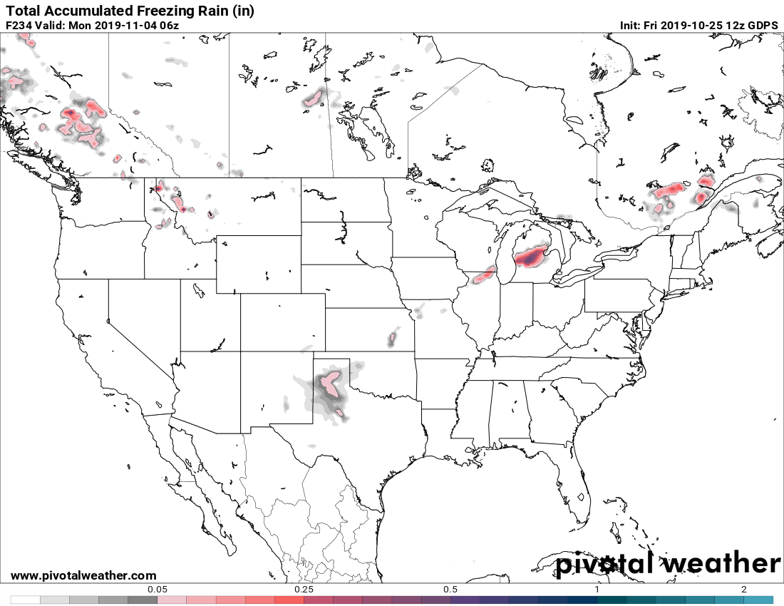
12z ICON still has the second storm, albeit MUCH MUCH weaker. 12z CMC has much of Iowa, northern Illinois, southeast Wisconsin and northern Michigan buried in 6+ inches of snow (late week system). Going to be really bad for the trees and disastrous for the crops. Not much wind in that system, though. Also, CMC says siggy ice storm for west central Michigan. We'll see what the 12z Euro says, although I'm pretty sure the Euro will show what the CMC shows, unless the Euro sides with the ICON and GFS. One more thing, all the GEFS ensembles show a significant snowstorm for eastern Iowa early next week, while it has the second system to the southeast of Iowa..png.d6ae3114b8ce90abc99316b0ace674fe.png)
-
Winter 2019-20 Medium/Long Range Discussion
Natester replied to Hoosier's topic in Lakes/Ohio Valley
12z ICON lost the late week storm. -
Here comes winter -- October 28-November 1 Snowstorm Potential
Natester replied to Hoosier's topic in Lakes/Ohio Valley
00z ICON no longer bombs, but instead has a MUCH weaker system. Also, first system is further west. -
Winter 2019-20 Medium/Long Range Discussion
Natester replied to Hoosier's topic in Lakes/Ohio Valley
12z ICON had the low travel due north from extreme western Kentucky into extreme southeast Wisconsin, there it does a loop. 850 mb winds are over 100 KNOTS in east central Iowa in the ICON. Let that sink in, that's surface gusts in the 70+ mph range. Thankfully the Euro and CMC has the low much further east. -
Winter 2019-20 Medium/Long Range Discussion
Natester replied to Hoosier's topic in Lakes/Ohio Valley
Yikes! For here, the winds won't be too bad in the late week system (although gusts will approach 40 mph), although we could get 4-6 inches of snow from that. The early week system snow line looks to be just west of west of here. Nonetheless, going to be disastrous for the crops as the harvest hasn't even began. The October 26, 1997 snowstorm ruined almost all of the soybean crop and half of the corn crop in the affected areas, according to the NCDC event log for that snowstorm. -
Winter 2019-20 Medium/Long Range Discussion
Natester replied to Hoosier's topic in Lakes/Ohio Valley
These two snowstorms are going to be disastrous to the harvest. Millions of dollars of crops will likely be lost due to the snow. Also, not so good news for the power grid as much of the trees still have leaves on them. -
Winter 2019-20 Medium/Long Range Discussion
Natester replied to Hoosier's topic in Lakes/Ohio Valley
ICON shows wind gusts approaching 80 mph over much of eastern Iowa with the late week blizzard, with snow accumulations over a foot. As for the Euro, the wind gusts are nowhere near as strong (only in the 40 mph range). We'll see if the 12z CMC shows it too because it looks like a repeat of 1991, except farther east and without the ice. -
Winter 2019-20 Medium/Long Range Discussion
Natester replied to Hoosier's topic in Lakes/Ohio Valley
12z Euro says repeat of 1991 (Halloween blizzard), albeit a couple days early, not as much wind and hardly any ice. Also, somewhere down the line I expect the GFS to latch on to this potential storm, unless the Euro and CMC loses the storm. -
Winter 2019-20 Medium/Long Range Discussion
Natester replied to Hoosier's topic in Lakes/Ohio Valley
00z Euro continues to crush IA, MN and WI with a blizzard next week. 00z CMC has two snowstorms next week also. 06z GFS and 12z ICON shows nothing so far. If the Euro or CMC verifies, look at the potential for widespread power outages due to most of the trees still having leaves on them (think of October 26, 1997). -
Historic Tornado Outbreak April 27, 2011
Natester replied to CUmet's topic in Weather Forecasting and Discussion
Compiled this playlist of all of the videos that I could find of the tornadoes on April 27, 2011. https://www.youtube.com/playlist?list=PLm_yeRok75NttgF3fZOvt2X7dLS5NfJtj -
Historic Tornado Outbreak April 27, 2011
Natester replied to CUmet's topic in Weather Forecasting and Discussion
New footage of the Tuscaloosa tornado. At the 35 second mark, you'll notice that it gets dark very quickly. After watching the video a few times, it appears that the tornado passed just feet from their house. -
Devastating tornado strikes Joplin, Missouri
Natester replied to Hoosier's topic in Weather Forecasting and Discussion
Not sure if anyone has seen this video. An 18-wheeler drives drives right into the tornado. He's lucky since the tornado had weaken to an EF2 when it crossed the interstate. -
Devastating tornado strikes Joplin, Missouri
Natester replied to Hoosier's topic in Weather Forecasting and Discussion
This is a new video of the joplin tornado. It shows it going from wall cloud to wedge tornado in just 60 seconds. -
Devastating tornado strikes Joplin, Missouri
Natester replied to Hoosier's topic in Weather Forecasting and Discussion
Where did you hear that from? -
Historic Tornado Outbreak April 27, 2011
Natester replied to CUmet's topic in Weather Forecasting and Discussion
http://www.youtube.com/watch?v=EC62TRfuJHY