

snywx
-
Posts
10,049 -
Joined
-
Last visited
Content Type
Profiles
Blogs
Forums
American Weather
Media Demo
Store
Gallery
Posts posted by snywx
-
-
2 minutes ago, crossbowftw3 said:
I would expect Binghamton to toss out an advisory for me by this afternoon’s cycle. Low end warning event may still be in the cards for us, rest of 12z and 18z will be telling. Very good ratios will pay dividends.
I’m only expecting 3-4” here. Gonna have to be east of the river to really cash in or increase those odds.
-
 2
2
-
-
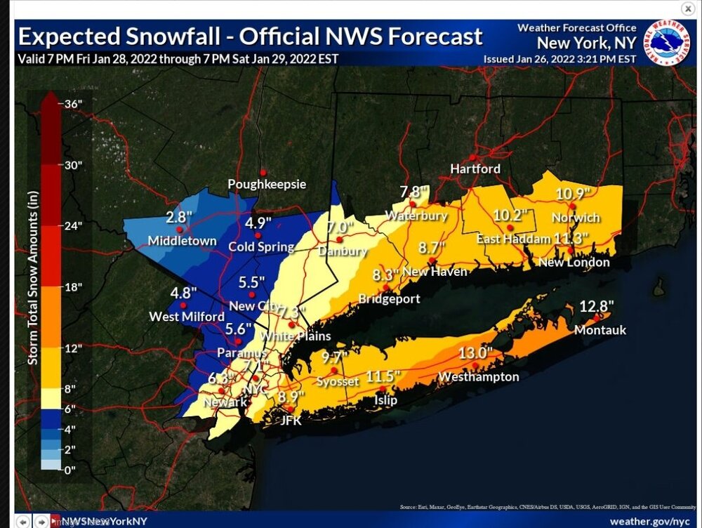
I think 6-10 within the city limits is a good forecast. Nassau/Suffolk border on east should be in line for an awesome event 12”+. Us up here In the great northwest should be in the 3-6” range.
-
4
-
-
17 minutes ago, crossbowftw3 said:
Think this could get pulled back enough for folks like @snywxto sneak a 2-4/3-6 event? Anything helps with such high ratios

This will be a nice 1-3" pack refresher for us up here in the NW. Im perfectly content with that.
-
 1
1
-
-
47 minutes ago, Juliancolton said:
-2.5 here. My spot is losing its edge.
I think snow cover is playing a role.. how much do you have left?
-
1
-
-
-5 for a low here
-
2
-
-
11 minutes ago, Lawnguyland said:
NWS seems to think we are getting a decent snowfall, which I understand can easily change in the next few days.
That’s basically a carbon copy of the 12z euro. By tonight it will be much different
-
2
-
-
Regardless of what happens this weekend it will still look quite wintry out there. Snowpack has held firm here
-
2
-
-
33 minutes ago, crossbowftw3 said:
The madness will never end
coming back to earth a tad, the EPS ticked east somewhat.
Take my word for it.. donot become heavily invested in this potential storm. The euro is most likely out to lunch. It’s literally the only piece of guidance getting anything back this way
-
5
-
-
1 hour ago, crossbowftw3 said:
6z euro

difference between 6” and 24” is 100 miles
I’ve seen worse.
-
1
-
-
Mood flakes all morning here.. I guess kind of a precursor for this weekend Flurries w/ sunshine!
-
1
-
3
-
-
2 minutes ago, crossbowftw3 said:
Tight squeeze for folks like @snywxand myself…not going to be shocked if this one won’t play in our favor while someone just 50-100 miles East pulls 20”.
I’ve seen this movie way too many times. It’s shades for us up here. This is a E LI, ENE special. We need a substantial shift for anything meaningful up this way.
-
 1
1
-
 1
1
-
 1
1
-
-
1 minute ago, WarrenCtyWx said:
I think you mean 2016.
Yeah.. they all the same lol
-
2
-
-
25 minutes ago, NJwx85 said:
Miller A's always have a narrow jackpot zone with a major screw zone just to the NW of wherever that sets up. See 1/26-1/27 2015 and to a certain extent 12/26/10 as examples.
It doesn't get any sharper than this.
![Ocean County Remembers the Boxing Day Blizzard of 2010 – 6 Years Later [VIDEO]](https://townsquare.media/site/394/files/2015/12/Dec26_27_2010_NJ_snow.jpg?w=750&q=75)
That 2015 storm prob had the sharpest cutoff I’ve ever seen. 1” of fluff here while 15 miles to my south had 18”
-
1
-
-
3 minutes ago, HeadInTheClouds said:
Thats only 12z Saturday so likely still snowing.
Classic interior hit. The minute I hear E LI is all snow I break out the sun screen cause it’s gonna be a beautiful day with broken cirrus up here
-
6
-
2
-
-
Just now, NEG NAO said:
where is the rain/snow line ? looks similar to GFS almost benchmark track..
Look again
-
16 minutes ago, HeadInTheClouds said:
CMC is not running on pivotal weather. Do you have any QPF or snow amounts from the french site?


-
3
-
2
-
-
Just now, MJO812 said:
Close to the coast

Beautiful.. too bad it’s 120hrs out
-
2
-
-
Nice steady light snow.
0.5” new otg
-
2
-
1
-
-
26f w/ lgt snow falling
Coating on all surfaces
-
8 for a low here
-
Mass suicide in this sub forum if the 18z GFS became reality
-
1
-
 1
1
-
-
Just now, Juliancolton said:
Strange night for sure in that regard. -15 in Bethel and -16 in Woodbourne stand out on a cursory look... wouldn't be surprised if a few hollows in Sullivan and/or western Orange touched -20.
-5.8 was the low here. My general call held up nicely in and around the valley, at least.
Would you think snowpack played a role here? Most of southern Sullivan county from Monticello down through Rock hill has a solid 10” down. Most areas on this side of the county still have a 6-7” snowpack.
-
2
-
-
Can’t remember the last time this area was the coldest around. Normally @IrishRob17or @Juliancoltonclaim that spot. Quick scan of nysmesonet show everyone in the area around 0 w/ Otisville still -8. Impressive
-
1
-
-
-11 for a low
currently -9.8
-
2
-


Interior NW & NE Burbs 2022
in New York City Metro
Posted
Good call.. I agree with a general 3-6” ( west-east) up here.