snywx
-
Posts
10,209 -
Joined
-
Last visited
Content Type
Profiles
Blogs
Forums
American Weather
Media Demo
Store
Gallery
Everything posted by snywx
-

Two Mdt to high impact events NYC subforum; wknd Jan 6-7 Incl OBS, and mid week Jan 9-10 (incl OBS). Total water equiv by 00z/11 general 2", possibly 6" includes snow-ice mainly interior. RVR flood potential increases Jan 10 and beyond. Damaging wind.
snywx replied to wdrag's topic in New York City Metro
Agreed.. Unless these rates pick up in intensity we will struggle to achieve 6" -
Two Mdt to high impact events NYC subforum; wknd Jan 6-7 Incl OBS, and mid week Jan 9-10 (incl OBS). Total water equiv by 00z/11 general 2", possibly 6" includes snow-ice mainly interior. RVR flood potential increases Jan 10 and beyond. Damaging wind.
snywx replied to wdrag's topic in New York City Metro
26° w/ Lgt snow 1" otg -
Two Mdt to high impact events NYC subforum; wknd Jan 6-7 Incl OBS, and mid week Jan 9-10 (incl OBS). Total water equiv by 00z/11 general 2", possibly 6" includes snow-ice mainly interior. RVR flood potential increases Jan 10 and beyond. Damaging wind.
snywx replied to wdrag's topic in New York City Metro
Looks like its midway through middlesex approaching SI- 3,610 replies
-
- 1
-

-
- snow
- heavy rain
- (and 5 more)
-
Two Mdt to high impact events NYC subforum; wknd Jan 6-7 Incl OBS, and mid week Jan 9-10 (incl OBS). Total water equiv by 00z/11 general 2", possibly 6" includes snow-ice mainly interior. RVR flood potential increases Jan 10 and beyond. Damaging wind.
snywx replied to wdrag's topic in New York City Metro
28/22 w/ lgt snow coating on all surfaces -
Two Mdt to high impact events NYC subforum; wknd Jan 6-7 Incl OBS, and mid week Jan 9-10 (incl OBS). Total water equiv by 00z/11 general 2", possibly 6" includes snow-ice mainly interior. RVR flood potential increases Jan 10 and beyond. Damaging wind.
snywx replied to wdrag's topic in New York City Metro
29/20 overcast here -
He’s not as close as you think. Im a few miles west of the city of Middletown.
-
Two Mdt to high impact events NYC subforum; wknd Jan 6-7 Incl OBS, and mid week Jan 9-10 (incl OBS). Total water equiv by 00z/11 general 2", possibly 6" includes snow-ice mainly interior. RVR flood potential increases Jan 10 and beyond. Damaging wind.
snywx replied to wdrag's topic in New York City Metro
If I had to draw a line on where the 6" line will be its prob from Mahwah to Suffern to Stony point across the river to Yorktown. -
Two Mdt to high impact events NYC subforum; wknd Jan 6-7 Incl OBS, and mid week Jan 9-10 (incl OBS). Total water equiv by 00z/11 general 2", possibly 6" includes snow-ice mainly interior. RVR flood potential increases Jan 10 and beyond. Damaging wind.
snywx replied to wdrag's topic in New York City Metro
I believe areas along the Walkill & Hudson are the lowest points of the county. Two areas in Orange county that should clean up is the Schnemunk area ( Highland Mills, Monroe ) & Shawangunk ridge area ( Otisville, Greenville ). I can def see some 12" reports coming from those areas.- 3,610 replies
-
- 1
-

-
- snow
- heavy rain
- (and 5 more)
-
Two Mdt to high impact events NYC subforum; wknd Jan 6-7 Incl OBS, and mid week Jan 9-10 (incl OBS). Total water equiv by 00z/11 general 2", possibly 6" includes snow-ice mainly interior. RVR flood potential increases Jan 10 and beyond. Damaging wind.
snywx replied to wdrag's topic in New York City Metro
27/20 here Expecting 8-12" -
12z GFS I know its strictly for entertainment purposes but the GFS along with other guidance continues to increase amounts in the immediate area

-
8-10" is my expectation here as well. Im sure a few spots throughout the area will hit 12" but it should be isolated.
-
Two Mdt to high impact events NYC subforum; wknd Jan 6-7 Incl OBS, and mid week Jan 9-10 (incl OBS). Total water equiv by 00z/11 general 2", possibly 6" includes snow-ice mainly interior. RVR flood potential increases Jan 10 and beyond. Damaging wind.
snywx replied to wdrag's topic in New York City Metro
Currently 25/19 here -
Two Mdt to high impact events NYC subforum; wknd Jan 6-7 Incl OBS, and mid week Jan 9-10 (incl OBS). Total water equiv by 00z/11 general 2", possibly 6" includes snow-ice mainly interior. RVR flood potential increases Jan 10 and beyond. Damaging wind.
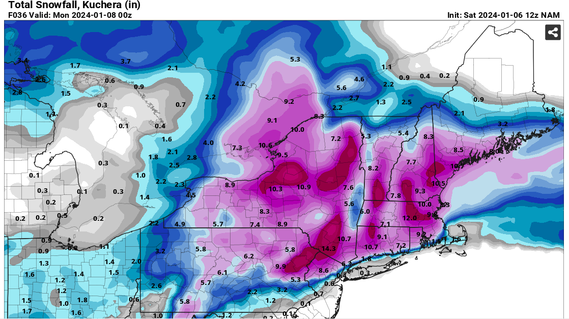
snywx replied to wdrag's topic in New York City Metro
12z NAM..
- 3,610 replies
-
- 2
-
-
- snow
- heavy rain
- (and 5 more)
-
Two Mdt to high impact events NYC subforum; wknd Jan 6-7 Incl OBS, and mid week Jan 9-10 (incl OBS). Total water equiv by 00z/11 general 2", possibly 6" includes snow-ice mainly interior. RVR flood potential increases Jan 10 and beyond. Damaging wind.
snywx replied to wdrag's topic in New York City Metro
Absolutely.. I think if anything O.C might jack this event.. Paul Goodloe from TWC is in the area lol- 3,610 replies
-
- 2
-
-
- snow
- heavy rain
- (and 5 more)
-
18z GFS looked nice for us interior folk. Actually bumped up precip amounts slightly. I think we are looking at 8-12" areawide (Orange,,Ulster,Dutchess,Sullivan)
-
Two Mdt to high impact events NYC subforum; wknd Jan 6-7 Incl OBS, and mid week Jan 9-10 (incl OBS). Total water equiv by 00z/11 general 2", possibly 6" includes snow-ice mainly interior. RVR flood potential increases Jan 10 and beyond. Damaging wind.
snywx replied to wdrag's topic in New York City Metro
Yeah thats my thinking as well. Thats prob gonna the area within the city limits that receives the most snow. Yonkers prob the same. You will prob start to see advisory level snows once you get into the HPN area.- 3,610 replies
-
- 2
-
-
- snow
- heavy rain
- (and 5 more)
-
Two Mdt to high impact events NYC subforum; wknd Jan 6-7 Incl OBS, and mid week Jan 9-10 (incl OBS). Total water equiv by 00z/11 general 2", possibly 6" includes snow-ice mainly interior. RVR flood potential increases Jan 10 and beyond. Damaging wind.
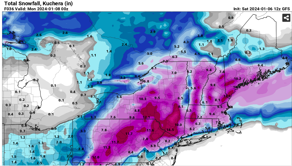
snywx replied to wdrag's topic in New York City Metro
12z GFS Kuchera
- 3,610 replies
-
- 3
-
-
- snow
- heavy rain
- (and 5 more)
-
Two Mdt to high impact events NYC subforum; wknd Jan 6-7 Incl OBS, and mid week Jan 9-10 (incl OBS). Total water equiv by 00z/11 general 2", possibly 6" includes snow-ice mainly interior. RVR flood potential increases Jan 10 and beyond. Damaging wind.
snywx replied to wdrag's topic in New York City Metro
Yeah.. Ive been doing the commute now for about 20 yrs. It can but the new bridge def helped with congestion. I cross that bridge at 6am and I cruise through- 3,610 replies
-
- 1
-
-
- snow
- heavy rain
- (and 5 more)
-
Two Mdt to high impact events NYC subforum; wknd Jan 6-7 Incl OBS, and mid week Jan 9-10 (incl OBS). Total water equiv by 00z/11 general 2", possibly 6" includes snow-ice mainly interior. RVR flood potential increases Jan 10 and beyond. Damaging wind.
snywx replied to wdrag's topic in New York City Metro
Transfer to the bx or uptown -
Two Mdt to high impact events NYC subforum; wknd Jan 6-7 Incl OBS, and mid week Jan 9-10 (incl OBS). Total water equiv by 00z/11 general 2", possibly 6" includes snow-ice mainly interior. RVR flood potential increases Jan 10 and beyond. Damaging wind.
snywx replied to wdrag's topic in New York City Metro
Trust me I know the feeling. Growing up in the BX in the 80s/90s I used to cringe when I frequently heard "NW of 287".. Being a weather weenie like many of us are, moving up here to orange county in 2000 was the best! Doubled my snowfall average in a short 55 min drive ( no traffic of course ) lol- 3,610 replies
-
- 2
-
-
- snow
- heavy rain
- (and 5 more)
-
Two Mdt to high impact events NYC subforum; wknd Jan 6-7 Incl OBS, and mid week Jan 9-10 (incl OBS). Total water equiv by 00z/11 general 2", possibly 6" includes snow-ice mainly interior. RVR flood potential increases Jan 10 and beyond. Damaging wind.
snywx replied to wdrag's topic in New York City Metro
HPN should be in line for a nice advisory event. I wouldn't be surprised to see some 1-2" reports coming from as far south as areas like Van Courtlandt in the BX. This is your classic 90s snowstorm- 3,610 replies
-
- 3
-
-
- snow
- heavy rain
- (and 5 more)
-
Two Mdt to high impact events NYC subforum; wknd Jan 6-7 Incl OBS, and mid week Jan 9-10 (incl OBS). Total water equiv by 00z/11 general 2", possibly 6" includes snow-ice mainly interior. RVR flood potential increases Jan 10 and beyond. Damaging wind.
snywx replied to wdrag's topic in New York City Metro
0z Ukmet- 3,610 replies
-
- 2
-
-
- snow
- heavy rain
- (and 5 more)
-
Two Mdt to high impact events NYC subforum; wknd Jan 6-7 Incl OBS, and mid week Jan 9-10 (incl OBS). Total water equiv by 00z/11 general 2", possibly 6" includes snow-ice mainly interior. RVR flood potential increases Jan 10 and beyond. Damaging wind.
snywx replied to wdrag's topic in New York City Metro
0z GFS Kuchera- 3,610 replies
-
- 1
-
-
- snow
- heavy rain
- (and 5 more)
-
Two Mdt to high impact events NYC subforum; wknd Jan 6-7 Incl OBS, and mid week Jan 9-10 (incl OBS). Total water equiv by 00z/11 general 2", possibly 6" includes snow-ice mainly interior. RVR flood potential increases Jan 10 and beyond. Damaging wind.
snywx replied to wdrag's topic in New York City Metro
I think anyone aoa 500’ in Rockland has a shot. Areas along the Hudson like tappan, south Nyack are a legit snow hole. North of sloatsburg should be 6”+ -
Two Mdt to high impact events NYC subforum; wknd Jan 6-7 Incl OBS, and mid week Jan 9-10 (incl OBS). Total water equiv by 00z/11 general 2", possibly 6" includes snow-ice mainly interior. RVR flood potential increases Jan 10 and beyond. Damaging wind.
snywx replied to wdrag's topic in New York City Metro
I think north Rockland & north Bergen have a legit chance at warning criteria snow.- 3,610 replies
-
- 4
-
-

-
- snow
- heavy rain
- (and 5 more)