

snywx
-
Posts
10,209 -
Joined
-
Last visited
Content Type
Profiles
Blogs
Forums
American Weather
Media Demo
Store
Gallery
Everything posted by snywx
-

Two Mdt to high impact events NYC subforum; wknd Jan 6-7 Incl OBS, and mid week Jan 9-10 (incl OBS). Total water equiv by 00z/11 general 2", possibly 6" includes snow-ice mainly interior. RVR flood potential increases Jan 10 and beyond. Damaging wind.
snywx replied to wdrag's topic in New York City Metro
31 here snow picking up in intensity again- 3,610 replies
-
- 3
-

-
- snow
- heavy rain
- (and 5 more)
-
31 here Snow picking up in intensity
-
Two Mdt to high impact events NYC subforum; wknd Jan 6-7 Incl OBS, and mid week Jan 9-10 (incl OBS). Total water equiv by 00z/11 general 2", possibly 6" includes snow-ice mainly interior. RVR flood potential increases Jan 10 and beyond. Damaging wind.
snywx replied to wdrag's topic in New York City Metro
000 NOUS41 KOKX 071303 PNSOKX CTZ005>012-NJZ002-004-006-103>108-NYZ067>075-078>081-176>179-080103- Public Information Statement National Weather Service New York NY 803 AM EST Sun Jan 7 2024 ...LATEST SNOWFALL REPORTS... Location Amount Time/Date Provider ...Connecticut... ...Fairfield County... 4 SSE Sherman 6.0 in 0701 AM 01/07 Trained Spotter Greenwich 4.5 in 1200 AM 01/07 Public Redding 4.0 in 1209 AM 01/07 Public Ridgefield 2.4 NNE 3.9 in 0700 AM 01/07 COCORAHS Stamford 3.5 in 1022 PM 01/06 Public 2 S New Canaan 3.0 in 0850 PM 01/06 Public 1 SE Wilton 3.0 in 1016 PM 01/06 Public 1 NNW Rowayton 3.0 in 1138 PM 01/06 COCORAHS Bridgeport Airport 3.0 in 0700 AM 01/07 Official NWS Obs Norwalk 3.0 in 0700 AM 01/07 COCORAHS Norwalk 2.8 in 1100 PM 01/06 Public Bethel 2.5 in 0620 AM 01/07 Emergency Mngr 3 E Easton 2.4 in 1140 PM 01/06 Public 3 WSW Shelton 2.1 in 0710 AM 01/07 Trained Spotter Stratford 2.0 in 0600 AM 01/07 COCORAHS Newtown 5.3 S 1.9 in 0700 AM 01/07 COCORAHS Stratford 1.8 in 1028 PM 01/06 Trained Spotter Ridgefield 1.8 in 0630 AM 01/07 COCORAHS Newtown 1.3 in 1045 PM 01/06 Public Trumbull 2.6 SSE 1.3 in 0730 AM 01/07 COCORAHS ...Middlesex County... Durham 3.2 in 0700 AM 01/07 COCORAHS Middlefield 1.4 W 2.5 in 0600 AM 01/07 COCORAHS Moodus 0.7 SSW 1.7 in 0700 AM 01/07 COCORAHS Westbrook 0.8 in 0742 AM 01/07 Trained Spotter Westbrook 0.5 in 0942 PM 01/06 Trained Spotter ...New Haven County... 1 E North Haven 3.0 in 1215 AM 01/07 Trained Spotter Naugatuck 3.0 in 0700 AM 01/07 COCORAHS Guilford 2.5 in 0645 AM 01/07 CO-OP Observer Seymour 1.2 WSW 2.5 in 0700 AM 01/07 COCORAHS Wallingford 2.0 in 1200 AM 01/07 Trained Spotter Milford 1.2 in 0910 PM 01/06 Public Madison 0.7 in 0700 AM 01/07 Public Meriden 0.5 in 0915 PM 01/06 Trained Spotter East Haven 0.3 in 0915 PM 01/06 Trained Spotter ...New London County... Norwich 2.7 in 0600 AM 01/07 COCORAHS Norwich 2.0 in 0700 AM 01/07 COOP Waterford 0.8 in 0700 AM 01/07 COCORAHS Preston 0.7 in 0730 AM 01/07 COCORAHS Niantic 0.5 in 0600 AM 01/07 COCORAHS Uncasville 0.5 in 0700 AM 01/07 COCORAHS Niantic 0.3 in 0915 PM 01/06 Trained Spotter Old Lyme 0.3 in 0700 AM 01/07 COCORAHS ...New Jersey... ...Bergen County... 1 N Franklin Lakes 5.7 in 1030 PM 01/06 Trained Spotter Franklin Lakes 4.0 in 0815 PM 01/06 Trained Spotter Glen Rock 4.0 in 0934 PM 01/06 Trained Spotter Ridgewood 3.7 in 1123 PM 01/06 Public Fair Lawn 3.4 in 1000 PM 01/06 Trained Spotter Westwood 2.8 in 0830 PM 01/06 Trained Spotter River Vale 2.8 in 0900 PM 01/06 Trained Spotter Bergenfield 1.0 in 0725 PM 01/06 Trained Spotter East Rutherford 0.5 in 0800 PM 01/06 Trained Spotter ...Essex County... North Caldwell 4.4 in 0535 AM 01/07 Public Livingston 3.6 in 1000 PM 01/06 Public West Orange 3.5 in 1130 PM 01/06 Public ...Hudson County... Harrison 1.0 in 0700 AM 01/07 COOP ...Passaic County... Totowa 5.0 in 0150 AM 01/07 Public Wayne 3.8 in 0730 AM 01/07 Trained Spotter ...Union County... Plainfield 2.2 in 0820 PM 01/06 Trained Spotter New Providence 1.7 in 0815 PM 01/06 Public Linden 0.7 in 0630 PM 01/06 Public Newark Airport 0.4 in 0700 AM 01/07 Official NWS Obs ...New York... ...Nassau County... Manhasset Hills 0.5 in 0736 PM 01/06 COCORAHS Plainview 0.3 in 0847 PM 01/06 Public ...New York (Manhattan) County... Central Park 0.2 in 0700 AM 01/07 Official NWS Obs ...Orange County... 2 SE Port Jervis 13.1 in 0630 AM 01/07 COCORAHS 3 NNE Unionville 12.4 in 1253 AM 01/07 Public Middletown 11.8 in 1215 AM 01/07 Fire Dept/Rescue Montgomery 11.0 in 1130 PM 01/06 Public 3 SSW Pine Bush 9.5 in 1201 AM 01/07 Public Salisbury Mills 9.2 in 0500 AM 01/07 Trained Spotter Newburgh 9.0 in 1125 PM 01/06 Public 2 SSW Stewart Airport 9.0 in 1205 AM 01/07 Public 1 WNW Monroe 8.0 in 1230 AM 01/07 Trained Spotter 2 E Highland Mills 7.5 in 1212 AM 01/07 Public Warwick 7.0 in 1030 PM 01/06 Public Chester 5.5 in 1015 PM 01/06 COCORAHS Highland Mills 4.8 in 1026 PM 01/06 Public Firthcliffe 2.9 in 0954 PM 01/06 Public West Point 2.5 in 0940 PM 01/06 Trained Spotter ...Putnam County... Cold Spring 6.5 in 0700 AM 01/07 COCORAHS Nelsonville 0.3 S 6.0 in 0700 AM 01/07 COCORAHS Cold Spring 6.0 in 0700 AM 01/07 Cocorahs ...Queens County... NYC/La Guardia 0.3 in 0700 AM 01/07 Official NWS Obs Little Neck 0.3 SE 0.3 in 0700 AM 01/07 COCORAHS NYC/JFK 0.1 in 0700 AM 01/07 Official NWS Obs Howard Beach T in 0700 AM 01/07 COCORAHS ...Richmond County... Westerleigh 0.2 in 0545 PM 01/06 Public ...Rockland County... Stony Point 4.0 in 0700 AM 01/07 COCORAHS Blauvelt 3.5 in 0922 PM 01/06 Public New City 3.0 in 1135 PM 01/06 Trained Spotter 2 W Buchanan 3.0 in 0720 AM 01/07 Public ...Suffolk County... Commack 1.3 SW 0.4 in 0700 AM 01/07 COCORAHS Commack 0.3 in 0800 PM 01/06 Public Ridge T in 1159 PM 01/06 COCORAHS Upton T in 0700 AM 01/07 Official NWS Obs Islip Airport T in 0700 AM 01/07 Official NWS Obs Orient Point T in 0700 AM 01/07 COOP ...Westchester County... Shrub Oak 4.0 in 0600 AM 01/07 COOP 2 WNW Jefferson Valley 4.0 in 0600 AM 01/07 CO-OP Observer Hartsdale 3.5 in 1040 PM 01/06 Trained Spotter Croton-on-Hudson 2.9 in 0945 PM 01/06 Public White Plains 2.8 in 1037 PM 01/06 Trained Spotter Ossining 2.5 in 0845 PM 01/06 Public &&- 3,610 replies
-
- 1
-
-
- snow
- heavy rain
- (and 5 more)
-
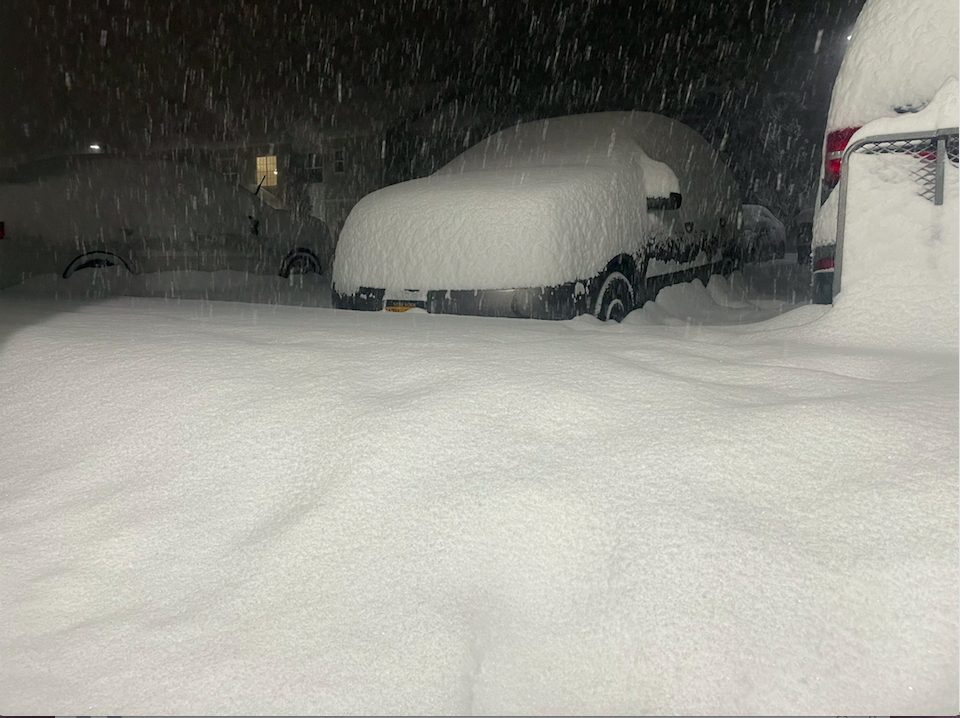
Some of the heaviest snow I've ever seen. Dropped 9" in just over 2 hrs. 12.2" otg here
-
Two Mdt to high impact events NYC subforum; wknd Jan 6-7 Incl OBS, and mid week Jan 9-10 (incl OBS). Total water equiv by 00z/11 general 2", possibly 6" includes snow-ice mainly interior. RVR flood potential increases Jan 10 and beyond. Damaging wind.
snywx replied to wdrag's topic in New York City Metro
It stretches from NE PA through extreme NW NJ into Orange county & Dutchess county- 3,610 replies
-
- 2
-
-
- snow
- heavy rain
- (and 5 more)
-
Two Mdt to high impact events NYC subforum; wknd Jan 6-7 Incl OBS, and mid week Jan 9-10 (incl OBS). Total water equiv by 00z/11 general 2", possibly 6" includes snow-ice mainly interior. RVR flood potential increases Jan 10 and beyond. Damaging wind.
snywx replied to wdrag's topic in New York City Metro
You can see where the band set up last night.. 10-15" in the band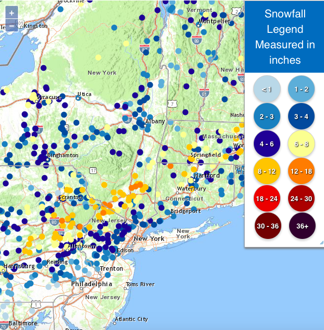
- 3,610 replies
-
- 3
-
-
- snow
- heavy rain
- (and 5 more)
-
Two Mdt to high impact events NYC subforum; wknd Jan 6-7 Incl OBS, and mid week Jan 9-10 (incl OBS). Total water equiv by 00z/11 general 2", possibly 6" includes snow-ice mainly interior. RVR flood potential increases Jan 10 and beyond. Damaging wind.
snywx replied to wdrag's topic in New York City Metro
29° w/ lgt snow 12.2" otg expecting an additional 2-3" today- 3,610 replies
-
- 3
-
-
- snow
- heavy rain
- (and 5 more)
-
Two Mdt to high impact events NYC subforum; wknd Jan 6-7 Incl OBS, and mid week Jan 9-10 (incl OBS). Total water equiv by 00z/11 general 2", possibly 6" includes snow-ice mainly interior. RVR flood potential increases Jan 10 and beyond. Damaging wind.
snywx replied to wdrag's topic in New York City Metro
27° w/ lgt snow 12" otg- 3,610 replies
-
- 6
-
-
- snow
- heavy rain
- (and 5 more)
-
That was impressive! 9" in just over 2 hrs
-
Two Mdt to high impact events NYC subforum; wknd Jan 6-7 Incl OBS, and mid week Jan 9-10 (incl OBS). Total water equiv by 00z/11 general 2", possibly 6" includes snow-ice mainly interior. RVR flood potential increases Jan 10 and beyond. Damaging wind.
snywx replied to wdrag's topic in New York City Metro
Didn't expect 9" in 2.5 hrs lol- 3,610 replies
-
- 2
-

-
- snow
- heavy rain
- (and 5 more)
-
Approaching 12" on this side
-
Two Mdt to high impact events NYC subforum; wknd Jan 6-7 Incl OBS, and mid week Jan 9-10 (incl OBS). Total water equiv by 00z/11 general 2", possibly 6" includes snow-ice mainly interior. RVR flood potential increases Jan 10 and beyond. Damaging wind.
snywx replied to wdrag's topic in New York City Metro
- 3,610 replies
-
- 11
-
-
- snow
- heavy rain
- (and 5 more)
-
Two Mdt to high impact events NYC subforum; wknd Jan 6-7 Incl OBS, and mid week Jan 9-10 (incl OBS). Total water equiv by 00z/11 general 2", possibly 6" includes snow-ice mainly interior. RVR flood potential increases Jan 10 and beyond. Damaging wind.
snywx replied to wdrag's topic in New York City Metro
For once we have a big bust incoming for us.. on the good side 11” otg heavy snow continues- 3,610 replies
-
- 5
-
-
- snow
- heavy rain
- (and 5 more)
-
Two Mdt to high impact events NYC subforum; wknd Jan 6-7 Incl OBS, and mid week Jan 9-10 (incl OBS). Total water equiv by 00z/11 general 2", possibly 6" includes snow-ice mainly interior. RVR flood potential increases Jan 10 and beyond. Damaging wind.
snywx replied to wdrag's topic in New York City Metro
Some of the hardest rates I've experienced in a long time. Im hearing reports of 12"+ in NEPA right now.- 3,610 replies
-
- 2
-
-

-
- snow
- heavy rain
- (and 5 more)
-
Even if its 1-3" tomorrow should feel quite wintry.
-
This band means business.. I know some of guidance picked up on sig accumulation on this side but i was skeptical. If these rates continue for another 2 hrs then 12" is not out of the question
-
Two Mdt to high impact events NYC subforum; wknd Jan 6-7 Incl OBS, and mid week Jan 9-10 (incl OBS). Total water equiv by 00z/11 general 2", possibly 6" includes snow-ice mainly interior. RVR flood potential increases Jan 10 and beyond. Damaging wind.
snywx replied to wdrag's topic in New York City Metro
Pat from 33 ? I trust his measurement then- 3,610 replies
-
- 1
-
-
- snow
- heavy rain
- (and 5 more)
-
Two Mdt to high impact events NYC subforum; wknd Jan 6-7 Incl OBS, and mid week Jan 9-10 (incl OBS). Total water equiv by 00z/11 general 2", possibly 6" includes snow-ice mainly interior. RVR flood potential increases Jan 10 and beyond. Damaging wind.
snywx replied to wdrag's topic in New York City Metro
At this pace ill have 9" by 11pm- 3,610 replies
-
- 2
-
-
- snow
- heavy rain
- (and 5 more)
-
Two Mdt to high impact events NYC subforum; wknd Jan 6-7 Incl OBS, and mid week Jan 9-10 (incl OBS). Total water equiv by 00z/11 general 2", possibly 6" includes snow-ice mainly interior. RVR flood potential increases Jan 10 and beyond. Damaging wind.
snywx replied to wdrag's topic in New York City Metro
27 w/ heavy snow 6.0" otg 3" in the last hour- 3,610 replies
-
- 1
-
-
- snow
- heavy rain
- (and 5 more)
-
Two Mdt to high impact events NYC subforum; wknd Jan 6-7 Incl OBS, and mid week Jan 9-10 (incl OBS). Total water equiv by 00z/11 general 2", possibly 6" includes snow-ice mainly interior. RVR flood potential increases Jan 10 and beyond. Damaging wind.
snywx replied to wdrag's topic in New York City Metro
Yeah im thinking maybe 5" more.. If these rates continue tho we can be in for a nice surprise. I think the catskills cash in- 3,610 replies
-
- 1
-
-
- snow
- heavy rain
- (and 5 more)
-
Two Mdt to high impact events NYC subforum; wknd Jan 6-7 Incl OBS, and mid week Jan 9-10 (incl OBS). Total water equiv by 00z/11 general 2", possibly 6" includes snow-ice mainly interior. RVR flood potential increases Jan 10 and beyond. Damaging wind.
snywx replied to wdrag's topic in New York City Metro
0z NAM shows 9-11" additional for this area. Interesting. I doubt it but nice to see- 3,610 replies
-
- 1
-
-
- snow
- heavy rain
- (and 5 more)
-
Two Mdt to high impact events NYC subforum; wknd Jan 6-7 Incl OBS, and mid week Jan 9-10 (incl OBS). Total water equiv by 00z/11 general 2", possibly 6" includes snow-ice mainly interior. RVR flood potential increases Jan 10 and beyond. Damaging wind.
snywx replied to wdrag's topic in New York City Metro
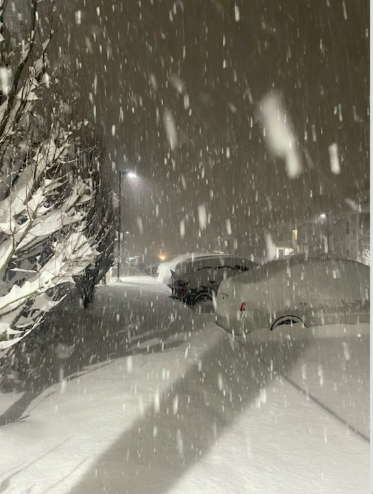
Heavy snow here 3.2" otg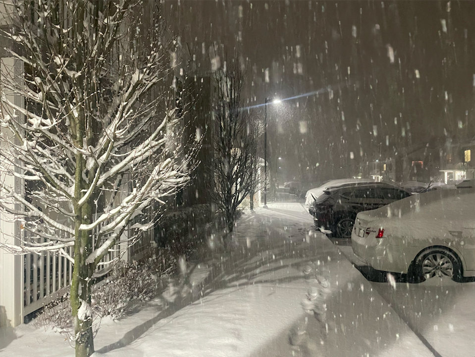
- 3,610 replies
-
- 6
-
-
- snow
- heavy rain
- (and 5 more)
-
Two Mdt to high impact events NYC subforum; wknd Jan 6-7 Incl OBS, and mid week Jan 9-10 (incl OBS). Total water equiv by 00z/11 general 2", possibly 6" includes snow-ice mainly interior. RVR flood potential increases Jan 10 and beyond. Damaging wind.
snywx replied to wdrag's topic in New York City Metro
No way he has 9" right now. Maybe half that- 3,610 replies
-
- 2
-
-
- snow
- heavy rain
- (and 5 more)
-
Two Mdt to high impact events NYC subforum; wknd Jan 6-7 Incl OBS, and mid week Jan 9-10 (incl OBS). Total water equiv by 00z/11 general 2", possibly 6" includes snow-ice mainly interior. RVR flood potential increases Jan 10 and beyond. Damaging wind.
snywx replied to wdrag's topic in New York City Metro
26 w/ heavy snow 2.8” otg- 3,610 replies
-
- 2
-
-
- snow
- heavy rain
- (and 5 more)
-
Two Mdt to high impact events NYC subforum; wknd Jan 6-7 Incl OBS, and mid week Jan 9-10 (incl OBS). Total water equiv by 00z/11 general 2", possibly 6" includes snow-ice mainly interior. RVR flood potential increases Jan 10 and beyond. Damaging wind.
snywx replied to wdrag's topic in New York City Metro
Same here.. Its a steady light snow but I was expecting some heavier rates by 0z