snowlover2
-
Posts
2,727 -
Joined
-
Last visited
Content Type
Profiles
Blogs
Forums
American Weather
Media Demo
Store
Gallery
Everything posted by snowlover2
-
Come on now. That's not entirely true.
-
6z NAM joins the other models farther south.
-

Winter 2019-20 Medium/Long Range Discussion
snowlover2 replied to Hoosier's topic in Lakes/Ohio Valley
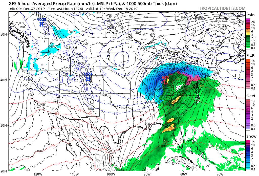
0z GFS with another teaser.
-
Actually it is.
-
0z Euro

-
0z GGEM
-
0z GFS
-
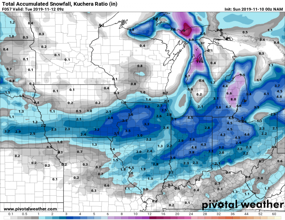
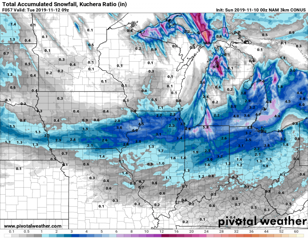
0z NAM and 3K NAM
-
Here comes winter -- October 28-November 1 Snowstorm Potential
snowlover2 replied to Hoosier's topic in Lakes/Ohio Valley
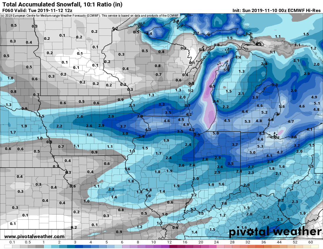
0z NAM for part 1.
-
Here comes winter -- October 28-November 1 Snowstorm Potential
snowlover2 replied to Hoosier's topic in Lakes/Ohio Valley
WAA up for parts of west central IL through tomorrow morning. -
Here comes winter -- October 28-November 1 Snowstorm Potential
snowlover2 replied to Hoosier's topic in Lakes/Ohio Valley
That wouldn't be a terrible track a couple months from now. -
2019 Short/Medium Range Severe Weather Thread
snowlover2 replied to snowlover2's topic in Lakes/Ohio Valley
SPC talking about it some in the day 4-8. -
Well sure feels like fall now. Has to be about 25-30 degrees cooler now than this time yesterday. Only 58 right now.
-
Dayton hit 94 breaking the monthly record of 93.
-
2019 Short/Medium Range Severe Weather Thread
snowlover2 replied to snowlover2's topic in Lakes/Ohio Valley
They did add a 5% tornado area but from NE KS to SW/South Central IA. -
2019 Short/Medium Range Severe Weather Thread
snowlover2 replied to snowlover2's topic in Lakes/Ohio Valley
Enhanced added to the IA/IL/MO border area for hail although a 5% tornado area added also.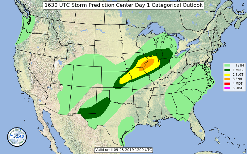
-
Northern parts yes. Also almost forgot March 7,8 2008. Most of the northwestern half of OH were under a blizzard warning receiving 10"+.
-
Actually 2004 pre Christmas dropped 20"+ across the western half of the state so arguably that was the last real big one.
-
New day 1.
-
A few counties in NW IN just added to current watch. That seems pretty telling that it's not going as far south as expected.
-
The new day 3 disco is short but with strong wording calling for a MCS with possible destructive winds because of extreme instability and also saying upgrades being likely in later outlooks. https://www.spc.noaa.gov/products/outlook/day3otlk.html
-
2019 Short/Medium Range Severe Weather Thread
snowlover2 replied to snowlover2's topic in Lakes/Ohio Valley
And the disco mentions an upgrade to moderate risk might be needed later. -
2019 Short/Medium Range Severe Weather Thread
snowlover2 replied to snowlover2's topic in Lakes/Ohio Valley
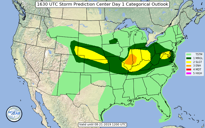
An enhanced area has been added to central IL for tomorrow on new day 2.
-
Warning just west of me with a 61mph winds reported at the Dayton Airport.
-
7-19 Severe outbreak MN into upper MI
snowlover2 replied to janetjanet998's topic in Lakes/Ohio Valley
You are correct. It was a tornado watch from MO/AR to KY/TN. There were 2 PDS severe thunderstorm watches to the west of that earlier that morning. https://www.spc.noaa.gov/products/watch/2009/ww0267.html