JoshM
-
Posts
3,182 -
Joined
-
Last visited
Content Type
Profiles
Blogs
Forums
American Weather
Media Demo
Store
Gallery
Everything posted by JoshM
-
I'm more excited over the cold coming in. I highly doubt I'll even see a flurry next week, unless I go to the Mountains.
-
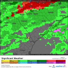
0z GFS literally gives western NC Piedmont the middle finger. Seems legit
-
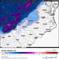
18z Clown Map... For entertainment purposes only
-
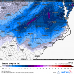
I can't disappoint the weenies... clown map below
-
Euro was hinting at that a day or two ago. Looks like another cold chasing moisture. One things for sure, the cold hammer will drop!
-
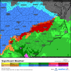
Euro gives most of NC a little love.
-
for my junk model images
-
-

us_model-en-087-0_modez_2019110400_198_480_215.png
JoshM posted a gallery image in Members Albums Category
From the album: Joshs
-
Sooo close to something good for a lot of us...
-
BOOM!
-
Ensemble looks colder... much better HP position.
-
And by hour 240 (ya, i know) the cold bomb drops
-
I'll take this look @ 150hrs anytime. And considering this is the first week of November
-
The camera operators said, "Nah, we're good"
-
81 now... 96 High No rain in the southeast, except Bank of America stadium
-
HP seems to be weaker and further North this run, allows it to come closer to coast.
-
Now Now, you know I'm the one who will jackpot
-
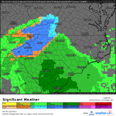
GSP morning discussion mentions ~ an inch along and NW of 85 GSP has also issued a HWO A low pressure system is expected to develop off the southern South Carolina coastline Tuesday morning. Precipitation developing well west of the storm center could impact parts of the western Carolinas, mainly during the morning hours on Tuesday. With relatively cold and dry air in place over the region, the precipitation could fall as snow in some locations, and light accumulations cannot be ruled out. All interests across the region should keep abreast of the forecast since significant changes are possible over the next 24 hours.
-
Was just about to post that. Still VERY weary after the abuse we've taken this year.
-
0z ICON isn't as happy as the NAM is, but is showing some
-
850s look decent, that's all I can see.
-
0z NAM brings moisture west of 18z
-
Euro looks interesting, too
-
us_model-en-087-0_modez_2019032900_111_480_155.png
JoshM posted a gallery image in Members Albums Category
From the album: Joshs
-
0z Icon is a MBY jackpot, I do love an April fools, on April 2nd