

weatherwiz
-
Posts
81,345 -
Joined
-
Last visited
Content Type
Profiles
Blogs
Forums
American Weather
Media Demo
Store
Gallery
Everything posted by weatherwiz
-
 I don't think storm chances were ever particularly high for today. Always seemed more isolated
 -
I still don't understand how ideas can be drawn on how a summer will be based on the concept of what *may* occur in terms of an ENSO event which is in the stages of development.
-
meh just a little warm
-
At WestConn we still had to use PowerPoint for our broadcasts because the school refused to pay for WSI and didn't care how important it was. I'm pretty sure they still use PowerPoint to this day.
-
It's going to be too much to ask to get something to time right in the Tuesday-Wednesday time frame, isn't it?
-
I can certainly imagine lol. Its interesting how the human brain works
-
Wish this concept was more easily grasp by the population
-
the headlines with severe weather are a joke. "Tens of thousands under the gun for severe weather". CNN and NY Post loves to do this. Then you have clowns like Ryan Hall and Max Velocity who have to use that headline and that have their stupid looking face making a stupid reaction in their thumbnails.
-
I really hope we can time an EML plume with the front next week but not looking particularly favorable right now...but we are a bit far out.
-
Made a comment on this a while back but isn't this sort of a product of the declining +AMO as we transition to a -NAO regime?
-
Hoisting the Sultan Signal: Heavy Rain Event July 5-7
weatherwiz replied to WxWatcher007's topic in New England
12z HRRR yesterday did a nice job with the idea today and then NAM followed suite. Been steady all day but has been heaviest over the past hour. Breeze picking up too -
Hoisting the Sultan Signal: Heavy Rain Event July 5-7
weatherwiz replied to WxWatcher007's topic in New England
Concern for some localized flash flooding, sure. But some of what was going around made it seem like flooding was going to be a large or widespread issue. But this is becoming a big problem in forecasting when it comes to some of these products. Folks see ensembles going crazy and all of a sudden alarm bells are sounded without fully divulging into all the data and then you have these products like extreme forecast index which further adds to the alarm bells. Yes, sure when you have these products showing something extreme there definitely should be concern, but they can't just be taken at face value nor should they be. Same goes with severe weather and winter weather...even in the west, a ton of events will get all hyped up with talk of tornado outbreaks and strong tornadoes because supercell composite parameter/significant tornado parameter forecasts are "through the roof" then the event comes and there are barely any tornadoes, let alone strong ones. And of course winter...D12 snowmaps show widespread 20-30" storms and here goes the social media hype for a massive blizzard. While sure there were guidance throwing around widespread 4-8" rain amounts and isolated higher totals, it was pretty clear that was not going to be the case and any amounts that excessive would most likely be extremely isolated or confined closer to where the warm front would be and it was also clear these totals would be spread out over a longer duration. Overall flood risk appeared low. Like I said earlier, watch in a few weeks we will get a setup with produces flooding and there will be little talk of the potential. For whatever reason it seems anytime talk of flooding is possible it never pans out, then we get setups where there is little mention of flooding possibility and you have problems all over. -
Hoisting the Sultan Signal: Heavy Rain Event July 5-7
weatherwiz replied to WxWatcher007's topic in New England
The amount of hype going around on this was insane. This was going to be nothing more but a much needed soaking rain for many...that is it. All these posts about models showing widespread 4-8" of rain, which by the way were showing jackpots across northwest CT and north when the axis of highest rains which much farther south which was mentioned of likely occurring. All this talk everywhere about flooding rains and blah blah. Steady soaking rain with a widespread 1-3" and of course some 3-6" amounts south where the axis ended up being....and of course spread out over a long duration. I mean were there even any flash flood warnings lol (maybe 1?). One of the most overhyped rain events ever. Nothing more than a soaking rain but I guess since how everyone thinks we're a desert now 3-4" is alarming -
Hoisting the Sultan Signal: Heavy Rain Event July 5-7
weatherwiz replied to WxWatcher007's topic in New England
Were there even any major flood reports or any flooding reports outside of the typical low street or poor drainage? All that was going around on social media you would have thought disaster was coming lol. Meanwhile in 3 weeks we'll get a setup with no flood watches, no WPC area for flooding, and half of the Merritt and stretches of 95 from CT into RI/SE MA will be underwater with cars trapped -
Hoisting the Sultan Signal: Heavy Rain Event July 5-7
weatherwiz replied to WxWatcher007's topic in New England
Have to head to the store later and grab a few things...definitely switching from shorts to jeans. going to suck -
Hoisting the Sultan Signal: Heavy Rain Event July 5-7
weatherwiz replied to WxWatcher007's topic in New England
Yeah but nothing near the widespread 4-6/5-7" that was floating around on some of the guidance. And the overall flooding risk seems relatively low...I don't think the moderate was necessarily needed by the WPC. This was a long drawn out steady rain (and kind of in chunks). Will be worse off to our south. Definitely a much needed rain for sure but overall this was below a much more concerning flooding risk -
Hoisting the Sultan Signal: Heavy Rain Event July 5-7
weatherwiz replied to WxWatcher007's topic in New England
Noah almost cancelled his plans in Heaven to come down and build an arc when he saw all these crazy ensembles and high extreme forecasts index. Good thing he decided not too -
Hoisting the Sultan Signal: Heavy Rain Event July 5-7
weatherwiz replied to WxWatcher007's topic in New England
The NAM does go ray with the LLJ too but still, if you want to see excessive rainfall amounts with a high flood concern, you're going to want to see a situation where the rain band is essentially stationary. This isn't exactly hauling but its not really crawling through either. -
Hoisting the Sultan Signal: Heavy Rain Event July 5-7
weatherwiz replied to WxWatcher007's topic in New England
This evolution doesn't scream flood to me outside of any typical spots that flood even when someone leaves their garden hose on too long. I want to see an expansive area of 35-40+ dbz which is almost not moving and with a continuous fetch of moisture and a continued blossoming of the precip shield with intense echoes so the rain shield is essentially stationary.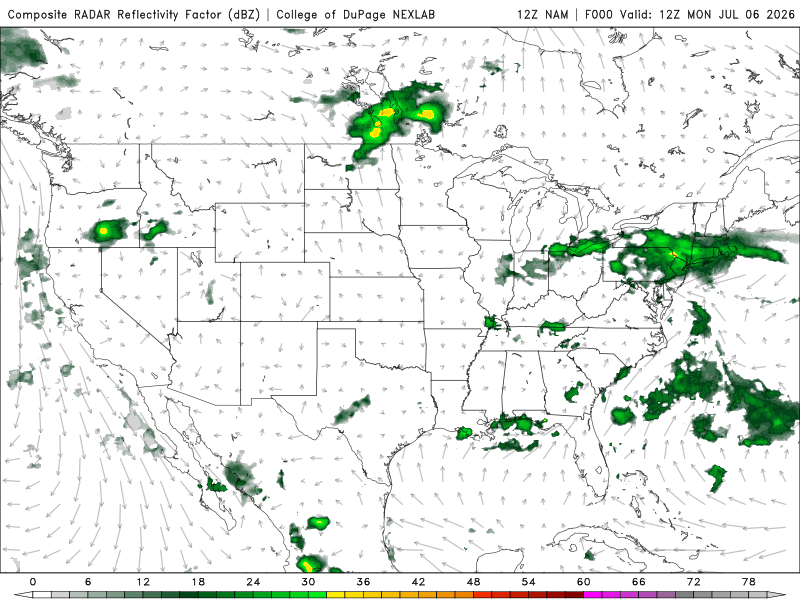
-
Hoisting the Sultan Signal: Heavy Rain Event July 5-7
weatherwiz replied to WxWatcher007's topic in New England
I think its safe to say, that can be tossed and tossed very far -
Hoisting the Sultan Signal: Heavy Rain Event July 5-7
weatherwiz replied to WxWatcher007's topic in New England
Goes very wild with the llvl jet -
We can only hope
-
Hoisting the Sultan Signal: Heavy Rain Event July 5-7
weatherwiz replied to WxWatcher007's topic in New England
IDK This really doesn't seem all that impressive nor does it look like it is going to evolve to be so. Just a good ole fashion steady, soaking rain. Highest totals probably end up coastal CT/Long Island. Congrats to the Fish in the Sound -
Hoisting the Sultan Signal: Heavy Rain Event July 5-7
weatherwiz replied to WxWatcher007's topic in New England
Good point. Towards the end of last summer when I would take the cover off before using it I would have bees flying out from it -
Hoisting the Sultan Signal: Heavy Rain Event July 5-7
weatherwiz replied to WxWatcher007's topic in New England
Looking like the max totals will def be towards the coast but probably nothing obscene. Probably some totals up around 4-5"...maybe someone gets 6"


