weatherwiz
-
Posts
75,223 -
Joined
-
Last visited
Content Type
Profiles
Blogs
Forums
American Weather
Media Demo
Store
Gallery
Everything posted by weatherwiz
-
 To steal a quote from the great Jack Edwards, "the euro with the point of the dragger in our throats and rips it out of our hands".
 -
Given where we are now in the timeline, this Euro run was probably about as disastrous as you would want to see. There was not even a hint of anything slightly not encouraging from the euro...not what you wanted to see. Even if we saw something encouraging, albeit tiny we could have worked with that. I am lowering my bar from 24'' to 0''. Screw winter. time for May
-
Didn't MSP get much of that on like one storm too?
-
The southern stream is becoming kind of a pain. Hell, they're on the fringes of a winter storm within Teas, Arkansas, and Tennessee and that whole ordeal is uncertain. Fort Worth is in a WSW but they may end up on the warmer side (just barely) and avoid much wintry precip. The 78-96 hour window is always a challenging one it seems with guidance when it comes to phasing situations. Not sure if there are some changes to equations or physics within models during this period but it seems to be prone to higher uncertainty when we see some decent certainty in the 96-120 hr window. EDIT: changed the second uncertainty to certainty in last sentence
-
Even some of these shittier OP runs, don't end up terrible. I think the idea of this being an all our hit versus nothing needs to be tossed out. This could still be something that gives at least parts of the region a few inches but I don't think this is becoming a 1-2 feet or shutout type deal.
-
Hasn't the GFS been doing that at times within a certain time range too? I recall at least a few severe setups in the Plains this past spring/early summer where something like that had an impact on how some of the events ended up performing.
-
the differences in H5 between the 12z GFS yesterday and today are absolutely insane. The whole evolution of H5 from model-to-model is wild. Hardly any consistency going on. It's way too early to write this off and of course that doesn't set this in stone but these swings in H5 are so large who the hell knows what the "middle" ground is or which side of the field to lean towards
-
This x100. This is a reason why we probably can't fully discount this until like 12z Thursday, even if things aren't looking so great today and tomorrow.
-
What a brutal storm that was from a forecasting side of things. Tough pill to swallow on that one
-
I think this has been mentioned several times but the PAC NW energy and the ridge is a huge factor in all this as well. Not only is there poor agreement with the northern stream energy but there is poor agreement within the PAC NW/western Canada domain. I've also been thinking this but I think this is a situation where ENS aren't going to be much use really. I mean ENS aren't going to tell us what we already don't know and that is a clean/early phase = big storm while no phase = nada or little. Just averaging out (or smoothing when looking at the mean) isn't going to give any insight as to what we can expect from the northern stream energy and the PAC NW ridge.
-
Yup...told my gf we were definitely getting a foot. ended up with 3.5'' or something
-
We've had the rug pulled out from under us the last minute before, maybe this can be a rare time it gets put back under us. IT'S COMIG DAMN IT. My bar remains at 24''.
-
New England Winter 2024-25 Bantering, Whining, and Sobbing Thread
weatherwiz replied to klw's topic in New England
While I have this on my mind... @OceanStWx what is the point of this accumulated Supercell composite parameter energy Index I saw floating around last spring/summer? -
Hopefully the last
-
Throwing it all in on this one, I've made up my mind. Winter for me is this weekend. 24" or bust for me. That's my bar...24". I want to be outside at 1:13 AM EST Sunday morning with my newly purchased yard stick I will be getting this week and sticking it in the snow as deep as I can and when it can't go in anymore...the top of the snow line better be at 24".
-
Just want to see EPS have some sort of stride towards the GEFS...that's all that would matter right now. Even if it was just a smidge of trend.
-
Looks like the difference with the northern stream energy become apparent in the 36-42 hour window. So it probably won't be until 0z at the earlies Tuesday night or 12z Wednesday morning that we get a much clearer idea of what guidance has the best general idea with the northern stream energy.
-
The differences between H5, not only with the northern stream, but the southern stream are absolutely wild but the differences are much more extreme with the northern stream. Must be a sampling difference...have to look at a larger view then just CONUS focused
-
A far western lean or a tuck right now isn't necessarily a bad thing. We know how this goes...there will be some last minute corrections...I guess as long as those corrections end up being east and not more west But I think the most tucked solutions are probably the envelops as to how tucked this can get. There is more room for east lean versus farther west lean
-
Weird to say but a part of me doesn't want to see a storm that strong lol. You start introducing some weird, finite and mesoscale processes which can make for forecasting hell.
-
Agreed. I am internally excited right now but waiting another 24 hours before I get overly excited. Probably better to wait until Wednesday to do that but all the pieces are there...its just about the timing.
-
IDK if that would be the case this time around, not with a storm that intense. Would probably start farther northwest but collapse quickly towards the northwest side of the center. Scott did just make a good point this would be more of a CCB than a deform and that also may favor something a bit closer to the northwest center of the H7 low, If I'm thinking correctly.
-
The deform with this would be unbelievable and would probably traverse a huge chunk of the region.
-
oh baby

-
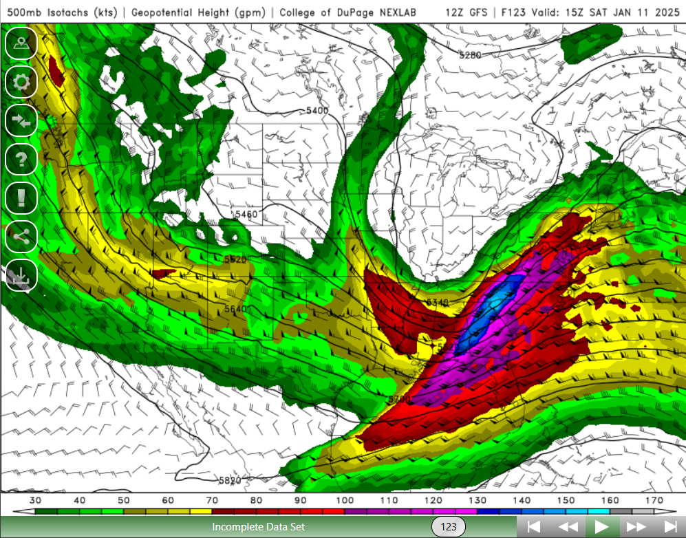
150+ knot 500mb jet streak develops as the core of the jet rounds the base across AL/GA...exactly what we want to see. Monster