weatherwiz
-
Posts
75,221 -
Joined
-
Last visited
Content Type
Profiles
Blogs
Forums
American Weather
Media Demo
Store
Gallery
Everything posted by weatherwiz
-
 My girlfriend had mentioned it to me a while back but I thought she was exaggerating a bit...but then recently (like a few months ago) there was a news story (may have been local Springfield station) on it and the Wal Mart here was like somewhere between #5-10 in the country...I want to say it was 5th lol.
 -
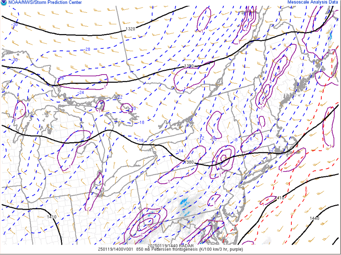
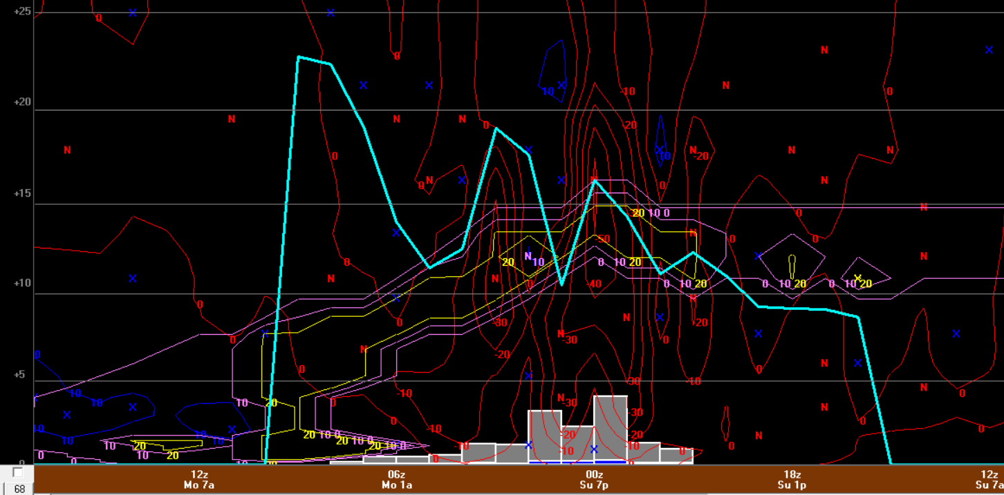
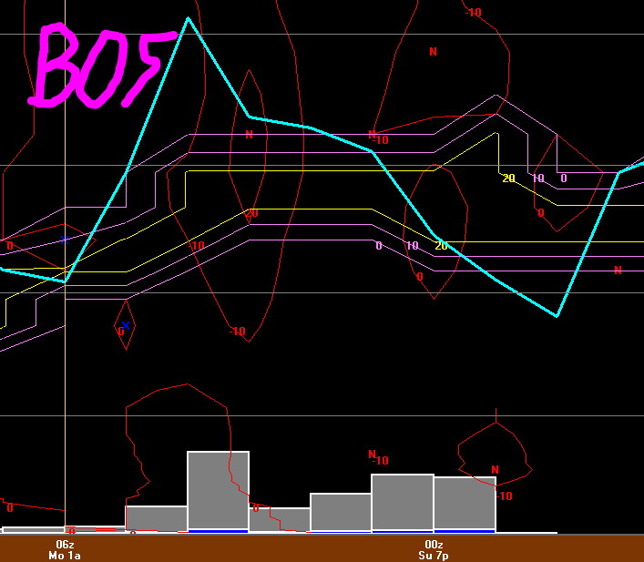
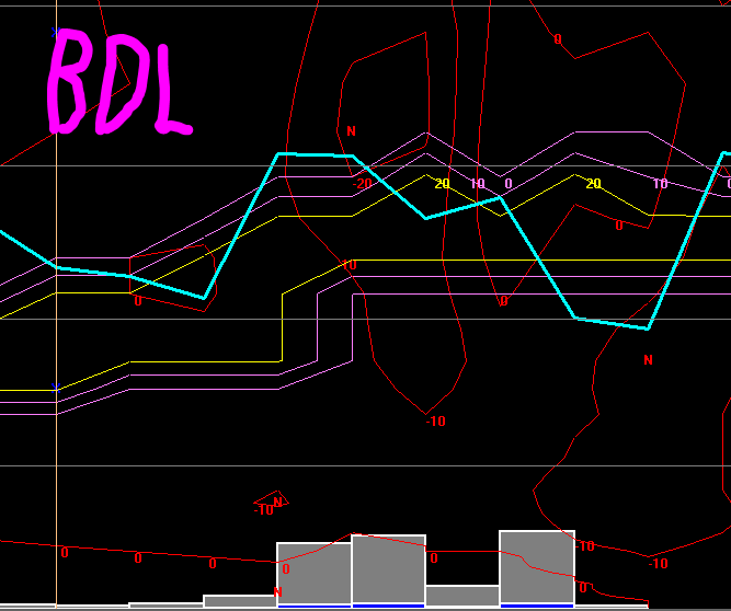
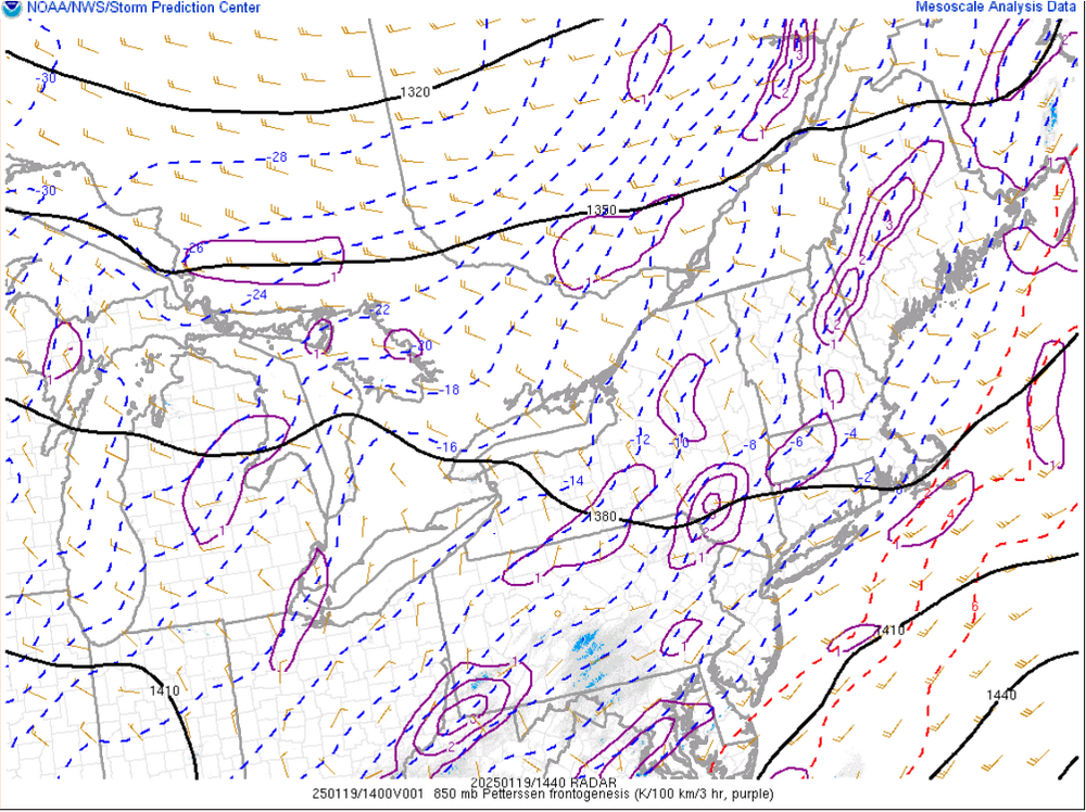
This is pretty interesting, however, I think it shows the significance of a band materializing and being under the band today. I'm becoming more and more convinced that outside of the banding...spots may struggle to get much past 3-4"...and this could end up being generous. Anyways, when I was looking at 12z NAM bufkit I was a little shocked. Based on 12z NAM bufkit, it looked like the heaviest banding would impact BOS-BDL and probably just west of ORH. But when assessing the model I would have thought the banding signal was better northwest of this line...unfortunately not much for bufkit profiles (CAN in northwest CT but it didn't look as impressive there). Here is a snip it of BOS/BDL. The window for accumulation is small and heavily tied into the banding.
-
Unfortunately I have a busy day ahead so my window to do that closed. Wal Mart is probably a disaster (and the Wal Mart here is always a disaster on a normal day...it's actually ranked as like one of the top 5 or 10 most violent in the country lol) and I'm sure everyone is at Big Y grabbing bread and milk.
-
Driveway here is still glazed and roads have a glazed look. I wanted to hit up Wal Mart/Big Y but I don't want to deal with any ice potential...not just myself but people drive like idiots. I'll just stay put.
-
Can see that setting up on mesoanalysis
-
I was going to do some errands around 6:30 this morning (may day started at 4:00 cleaning a dog pee/poop party ). I go outside and everything was glazed...I was not chancing driving anywhere. Errands weren't that important.
-
This is a big flag right now, IMO. At least the HRRR (haven't checked the RAP) doesn't seem like it gets any banding going. Or if it does it is nothing to sneeze at.
-
I think there are alot of little nuisances going on. But this is continuing a common trend we've seen with storms within compressed flows these last at least few winters. We get some really amped looks and everyone gets excited, there is an expectation there will be a cave geared towards the more amped models we we start to see say this around 48h. Then we get inside 36 hours and its a collapse and trend towards the less amped. Let's say that is the result when all said and done here...then clearly there is something within this 0h-72h window that forecast models struggle with mightily. There is something within the physics that models seem to be extremely sensitive too.
-
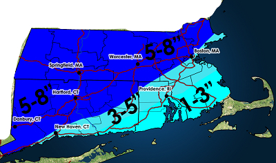
I do think there will be some 10-12" totals but outside of the banding I think we're looking at the lower end for snowfall ranges. It's still going to be a decent event...I would anticipate still a widespread 5-6" for most.
-
This is going to be a total nowcast. I am really not sure what to make of the QPF outputs. I feel like outside of the heavier fronto banding the QPF is going to underperform. The NAM has me really nervous too with what looks like the idea of two bands (one centered around Albany and the second northeastern Mass into northeast CT/far northwest RI maybe?). The GFS also kind of hints at this too but seems to phase the bands together and CT into northeast MA gets smoked.
-
And I get to go forth with my May 1st thread
-
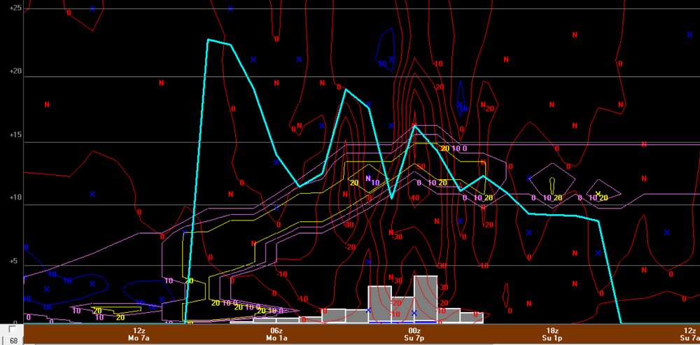
The other reason I hate snow maps is they aren’t stimulating. There’s nothing like loading up bufkit, clicking the overview tab, hitting reset, checking off snow growth, checking off omega, checking that box next to omega, going into the precip panel, clicking snowfall and precipitation and setting snow ratio to Cobb…now that is one of the most stimulating sequences there is.
-
I’m nervous that ratios are going to be subpar outside of the banding. Probably barely 10:1 despite the airmass
-
It was at ORH…at least 12z gfs was. Beautiful crosshair…rip of clothes type stuff
-
Ratios should be great but going to need to get some good lift to do so. I’m worried that outside of the banding the lift may not be all that great and ratios won’t be the best. I debated going 4-7” but I do think at least part of the state gets into banding
-
Threw this together earlier. While there is a strong idea for one (maybe two) fronto bands, it’s nearly impossible to know where they occur right now. I do think you’ll see 812” where it happens but not enough confidence where that occurs to highlight on a map. Also worried for some subsidence zones where snow growth and rates will be awful and that will hold totals lower somewhere. Of course any last minutes ticks in either direction have huge implications too
-
Let me know how Lysell looks
-
ORH will be getting thunder tomorrow!!
-
GFS bufkit remains pretty impressive looking at ORH.
-
Verbatim they could be in the jackpot zone. I'm curious though if the Euro is a bit too far southeast with the heaviest banding. Not just saying that because of the known bias that the heaviest banding tends to be northwest of what models show but because the evolution of the storm makes sense for the banding to develop well northwest and then maybe collapse towards center, but not sure that happens in this case without lack of H7 development. I still also wonder if we see two bands develop. One well northwest that smokes Berkshires and northwest Connecticut and a second which would be from about BOS through ORH to Kevin and in between gets kind of screwed. I am a little nervous about this scenario.
-
does anyone have any H7 VV maps they can post. weathermodels blows
-
I just edited the post...the wording was horrific Hopefully anyone who read it understood what I was trying to say. Haven't finished my coffee yet.
-
One thing to be careful of when using QPF to diagnose trends in the track is an increase/decrease in QPF can also be related to mlvl evolution. Yes that is also influenced on track but there are other factors to consider.
-
One of the few times we can probably ask NYC
-
I have a deal...if guidance doesn't collapse towards the Euro then I will not make a May 1st thread. So for a compromise, if the compromise isn't Euro favored then no May 1st thread.