weatherwiz
-
Posts
75,221 -
Joined
-
Last visited
Content Type
Profiles
Blogs
Forums
American Weather
Media Demo
Store
Gallery
Everything posted by weatherwiz
-
 Certainly not the mark model
 -
Speaking of bufkit, I wonder if this should have been a major flag. The snow ratio (using cobb method) was all over the place...it looked like an seismograph after an Earthquake. I wonder if that should have been a clear cut signal that outside of heavier banding, the ratios and snowgrowth would be pretty bad.
-
It's awesome how great of a tool bufkit is for diagnosing snowfall. That was illustrated beautifully...both hourly rates and duration.
-
I gotta stop getting so heavily influenced by the cute SLP/QPF maps...that's what tends to get me, especially when you'll have say like the GFS which isn't going to resolve some of the finer nuisances like the mesos would so it has that beautiful looking QPF shield. Gotta get these questions embedded into the noggin: 1) Does the QPF on that widespread of a scale make sense? 2) If that QPF makes sense, what is happening with that QPF (which this question could have a subset of several additional questions)? 3) What is going on with llvl and mlvl storm evolution and how is that impacting overall lift? Is there going to be a heavy reliance for narrow bands of frontogenesis or are we looking at a larger scale source for greater and more intense banding? How this precipitation shield evolved...IMO the NAM and Euro really nailed it but I can remember that 12z NAM run from Friday...seemed like so many were quick to discount it because the precip shield didn't make sense...well it did make sense and the reasons why it made sense, verified nicely. Heavier stuff northwest, kind of crap in the middle unless you got lucky with some narrow bands, and then heavier stuff northeast.
-
I'm pissed at myself for going 5-8" for such a large area but I was unsure how to really translate all the concerns into map form lol. The swaths of highest totals ended up being where I was thinking and there was pretty good support for that. This is why sometimes QPF is one of the last things I'll really look at. You start looking at QPF output right away and the beer goggles go on. I mean you can get a general sense of what QPF will be like anyways assessing everything. I am glad though I didn't go bonkers with those amped solutions starting arising in the typical 72ish hour time frame.
-
It does look beautiful outside, everything caked in snow with blue skies. This makes winter and frigid temperatures more enjoyable and tolerable.
-
Have to give some kudos to the NAM here. I don’t understand why everyone is always so hot and heavy to just toss it, especially when it doesn’t show a solution that is unwanted. It did a phenomenal job hitting at that northwestern band, kind of crap in between and then heavier banding for northeast areas. The whole process leading up to this storm and then the nowcasting period shows exactly there is more to just forecasting snow based off of QPF and figuring out snow ratio and it goes to show that QPF can’t just be taken at face value. A lot of wheels should be spinning in one’s head when assessing QPF. From a forecasting perspective though, a lot of how this storm played out went exactly how several mentioned. There were concerns about snow growth, rates, and ratios outside of the banding and that would heavily influence totals. The challenge is, how the heck do you portray that on a snow map? You really can’t…probably best to just be as cautious as possible with the totals and mention localized higher amounts.
-
Kind of difficult to get a good reading with the wind but seems about or around 4”. Will wait for final regional snow totals but going to be a good ole D on the forecast
-
In a dead zone right now
-
hopefully some of those totals in NJ are a good omen but also going to need this to consolidate some over CT...good banding signal but its very streaky
-
Radar seems to be filling in across southwest Connecticut
-
Looking good out your way with the band. Not very far outside those heavier echos but wind is so gusty its probably blowing snow from that band here
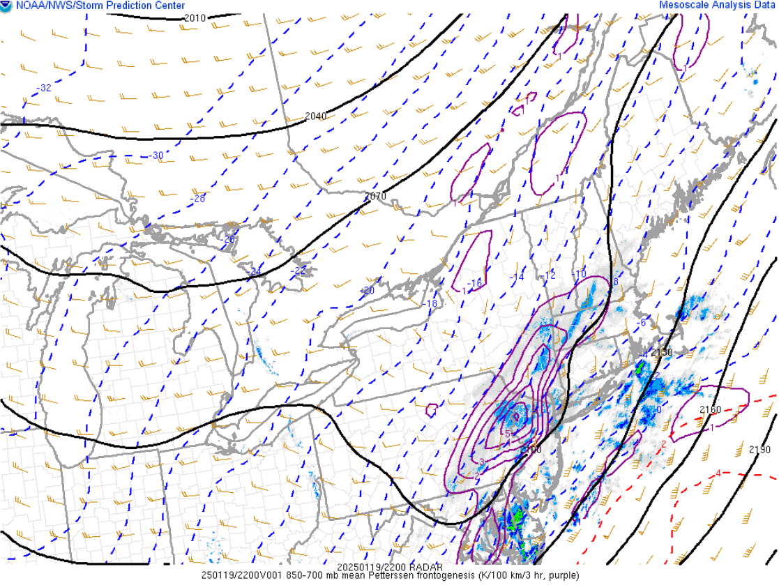
-
This band is going to ramp up over the next few hours. mlvl fronto continues increasing. Northeast CT into Northeast MA is going to get hit good...band really cranks by then as sfc low deepens as it lifts northeast
-
That's exactly how my brother texted too. Said he saw a flash of lightning and then a huge bang of thunder. He's like equal distance from Plainville/Farmington lines give or take
-
You're probably not wrong
-
We've waited all winter for this. It's rock and roll time
-
Brother in New Britain just reported thunder/lightning
-
The lightning also may not be C2G so not being picked up or displayed?
-
I'm getting more optimistic too you may see the band strengthen some as it crosses CT. I was thinking today the lower end of my 5-8" was going to be the case but starting to think there could be lots of 7-8''.
-
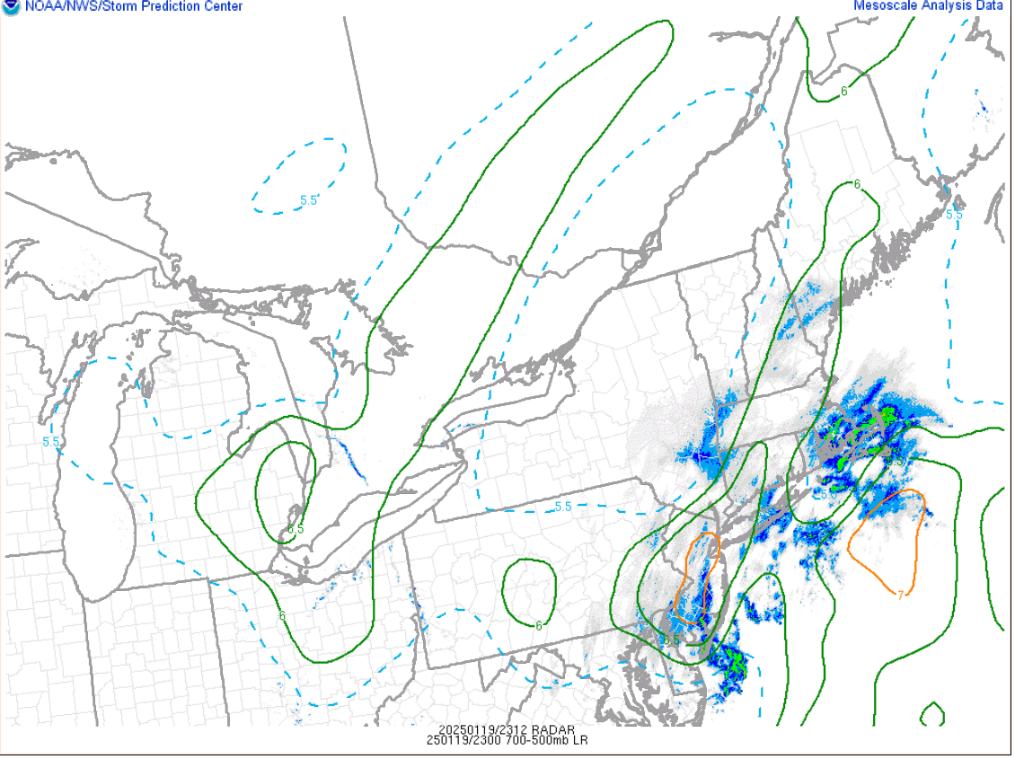
Steep mlvl lapse rates. I bet there is a good MAUL on some HRRR soundings. I know models were hinting at that

-
Mesosyanlsys is encouraging in that regard. Has me cautiously optimistic good banding gets much of the region.
-
Been a growing concern of mine the last day. It will be fun and wild for a time under the band but outside the band snowgrowth and ratios will be very questionable.
-
Parts of the deep South will end up with more than a good chunk of us may Was looking at LFT on bufkit...pretty wild for down there.