calculus1
-
Posts
5,305 -
Joined
-
Last visited
Content Type
Profiles
Blogs
Forums
American Weather
Media Demo
Store
Gallery
Everything posted by calculus1
-
Oh, and as we are approaching 11 PM, I have recorded 5.12 inches since midnight IMBY. With 1 inch yesterday, that puts me above 6 inches storm total.
-
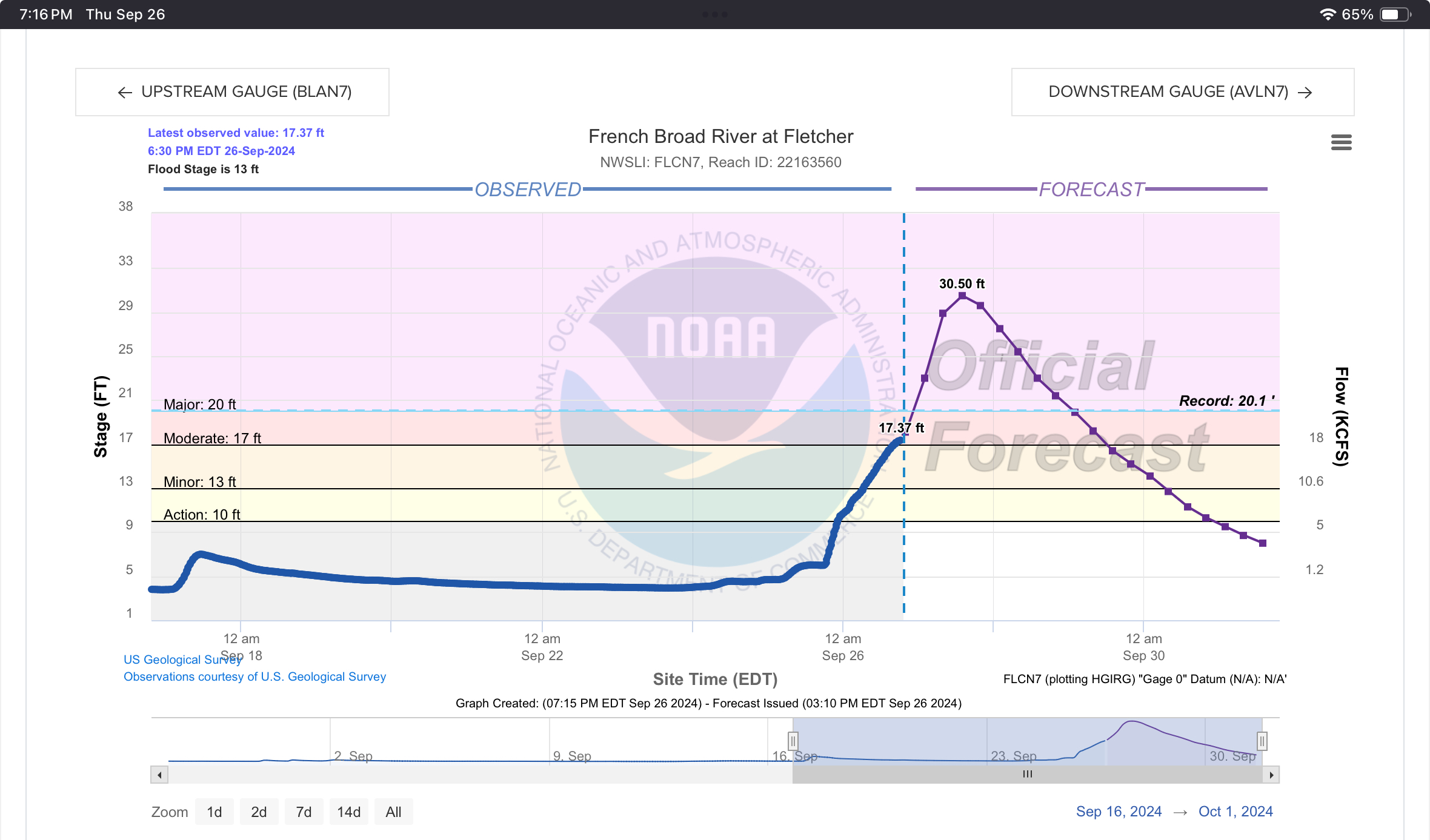
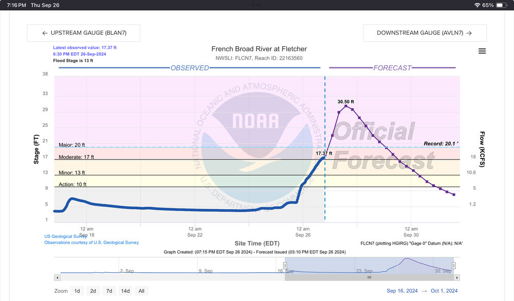
My family members are reporting that Buncombe County emergency text messaging is telling people to evacuate if they live in and around the French Broad, the Swannanoa, or any of their tributaries. I think they are particularly worried about the Fletcher and Biltmore Village areas, but this will likely be much more expansive by tomorrow morning.
-
Others have referenced this. Here’s the graphical forecast. .
-
Just got home. Closed the college early. 3.02 inches since midnight. 4.02 inches storm total counting yesterday’s rainfall.
-
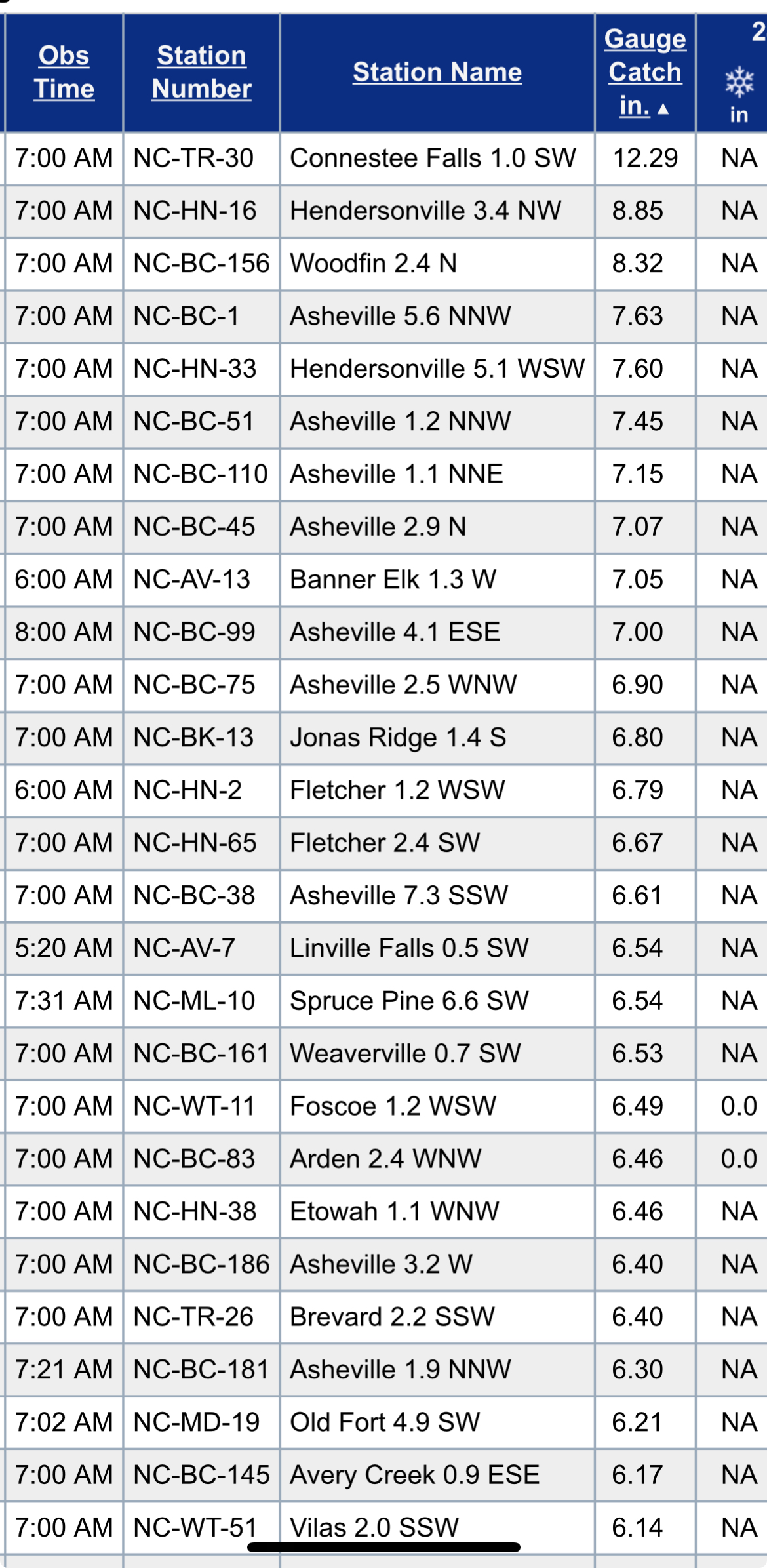
More Cocorahs totals coming in… .
-
Wow. Just. Wow. .
-
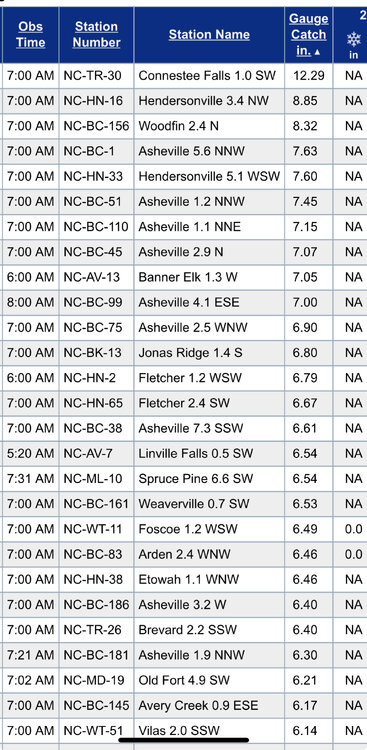
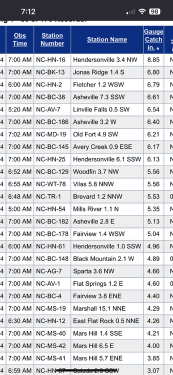
Yep. Found an Old Fort number, as the obs keep rolling in. 6.21 inches. Yikes. What’s @Rainforrest up to now? .
-
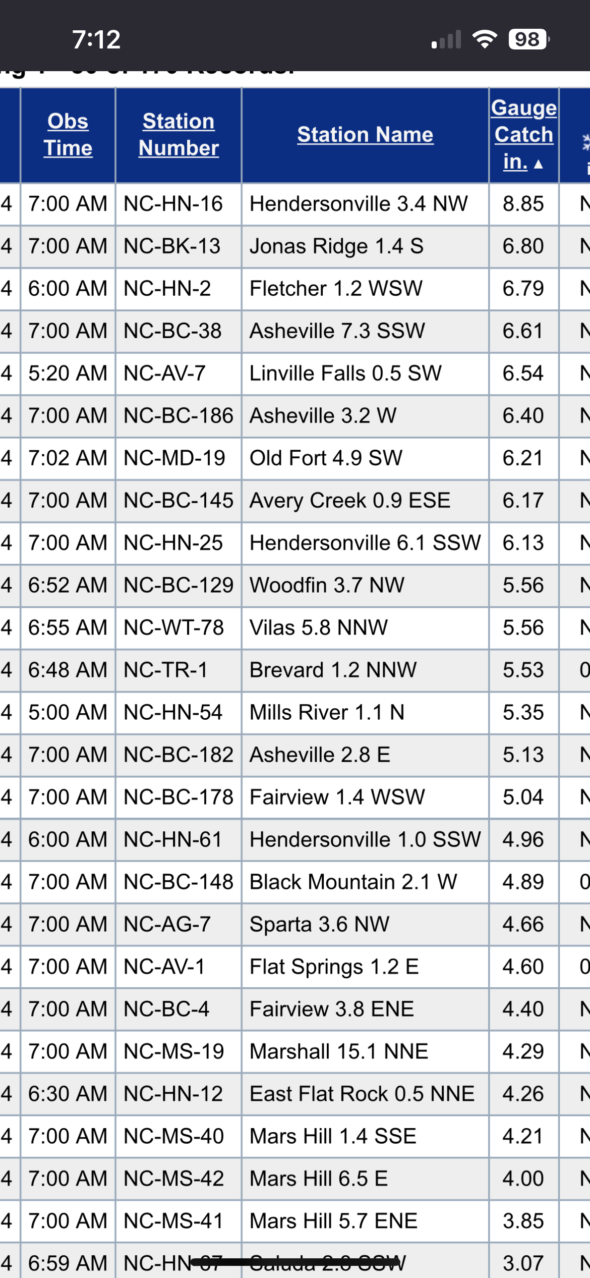
Corcoran observations coming in at 7 AM… .
-
Got another inch since midnight. Light rain now. Anybody got a rain gauge near Old Fort? Really curious on their totals. It trained on them all night. .
-

2024-2025 Fall/Winter Mountain Thread
calculus1 replied to Buckethead's topic in Southeastern States
Can you post the link? -
I have family in Old Fort that live across the street from the Catawba River. I also have family in Black Mountain, but not near any streams or rivers. Really worried about this one for both of them. I think they both see upwards of a foot of rainfall out of this. The point-and-click NWS forecasts are pretty insane for both locations. I’ve never seen the language for rain totals that it is using for Black Mountain tomorrow night: “New precipitation amounts in excess of 4 inches possible.” The other time frames are also huge. Old Fort isn’t much different. I keep sending my family updates, as I have them, since I am much more into following weather events than any of them. I appreciate all the reports and posting that ya’ll provide on here.
-
That line of precursor rain has not advanced far east at all. We got an inch of rain overnight, but it hasn’t really rained at all today. Maybe it will pick up overnight, but I’m not too anxious for those high totals anyway.
-
Keep everything here, IMO. .
-
3.50 inches exactly was my final tally. All of that fell within the calendar day of 8/8. .
-
2.6 inches of rainfall IMBY as of about 30 minutes ago, according to my wife. Rainfall began around 6:30 AM. .
-
Hurricane Debby - flooding rain threat region wide
calculus1 replied to olafminesaw's topic in Southeastern States
Very different results for western parts of the Carolinas. . -
I had 8.45 inches going back to 7/10 within July. I can’t go back any further on my Vue console, and I forgot to check the monthly total before flipping to August. I’m at 41.26 inches for the calendar year. .
-
Yeah, that was a crazy storm last night. We got almost 1.5 inches out of it. Very intense rainfall and lightning. Glad your property and family are okay. .
-
Much more rain IMBY since Saturday. I am in New Orleans for work, so I don’t have totals, but radar back home has been robust. .
-
I got almost an inch of rain this evening! Amazing. I am still rolling with fescue, as it looks beautiful all year round other than July/August, and I do not have irrigation. I pay Turf Pro to do the fertilization, grub control, liming, and fungicide. I pay to have the lawn aerated and over-seeded each fall. My boys and I do all the mowing, though. Because of the recent lack of rain, tomorrow will be the first time that we mow in almost one month. I've been afraid to mow because of the stress it would cause on the grass with very little rain recently. (It also hasn't grown much at all.) The fescue has survived fairly well in all the shaded areas, but is very crispy in the areas that get full sun.
-
I eked out 0.29 inch of blessed rainfall early this evening. It was amazing! I had almost forgotten what rain was like...
-
Ya’ll in the east really benefited today. We continue to be drought central here in Hickory. Ugh…
-
Yes, this summer has been miserably hot and humid. I was fortunate to escape to Alaska for two weeks, but otherwise it has been “Yuck!”
-
Same for me. It’s been raining all around me, but just a random sprinkle or two hear IMBY.
-
Been in Alaska for the past two weeks, camping and hiking. Mornings were in upper 40s and afternoons never got warmer than mid 70s. Most afternoons were in the 60s, particularly where we were hiking at elevation. Made it home last night and checked my PWS. Only 0.11 inch of rainfall IMBY over that period. Ugh! Yesterday’s high was 100.4 IMBY with a heat index of 120! I don’t think I’ve ever seen it that high on my Vantage Vue. I may challenge it today, though. Current temp is 92.5 at 1 PM. Heat index is reading 105. .