Floydbuster
-
Posts
3,044 -
Joined
-
Last visited
Content Type
Profiles
Blogs
Forums
American Weather
Media Demo
Store
Gallery
Everything posted by Floydbuster
-
Since I'm less seasoned in winter weather, what do the odds of snow look like for Northern Ohio? I have people going nuts thinking a blizzard is coming in 48-72 hrs.
-
 Cute little cane.
 -
2019 Atlantic Hurricane Season
Floydbuster replied to AfewUniversesBelowNormal's topic in Tropical Headquarters
Thanks alot. They'll probably get rid of it now. -
What the hell is with all these Cat 5s? We used to get them once in a while, sure. Hugo 89, Andrew 92, Mitch 98. But it was like...three per decade. Most "insane" storms peaked as Cat 4s. Think Georges, Floyd, Lenny, Keith, Iris, Michelle, Isidore and Lili. Ever since Isabel 2003, the last 16 years have given us 14 Category 5 hurricanes. I'm a skeptic as far as global warming and hurricanes, as the late Dr. William Gray told me personally that there was no correlation. But I am a little surprised at the surge in Cat 5 hurricanes. Is it better aircraft and satellite data?
-
I'm looking at these models in the 5-7 range, and I'm literally saying outloud: Why isn't Karen moving? That ridge is dominant as hell, this thing should be sailing into Key Largo and Corpus, yet it spins like an idiot in the Sargasso Sea for a week.
-
Meh. Not as excited about tracking this one as I was a few days ago. The "slow motion" doesn't bode well. If she moves briskly, then we could have something.
-
You and Josh may be interested in this: https://journals.ametsoc.org/doi/pdf/10.1175/2007JCLI1772.1 Discussing return periods for sub-900 mb hurricanes in the United States. "The 1935 Labor Day Florida Keys storm was the most severe in our dataset. With a 265-yr wind speed return period and a 102-yr central pressure return period, it presses the fitted model boundaries. We believe this is due in part to the extreme southern latitude of this landfalling storm. Another storm of this intensity would likely again require a very southern landfalling latitude, with the Florida Keys or the Brownsville, Texas, region being the most likely hosts." Very interesting. That means, according to "return periods", a sub-900 mb U.S. landfall should come around again in about 10-20 years. But I'm also envisioning a Brownsville landfall of a storm of that intensity. I picture a pinhole eyewall on a morning visibile crossing South Padre Island. I can picture Josh now, a big white beard, tweeting from Port Isabel.
-
Comparing Josh's vid and this Mexico Beach Michael vid, they both in my opinion, show sustained Category 5 winds. The "whiteout" conditions in both storms is very similar to the infamous gas station video in Charlotte Harbor during Hurricane Charley, where the tiny and fast moving eyewall briefly produced sustained Category 4 winds and a gust to Cat 5 within several seconds which destroyed the gas station. The "whiteout" conditions are seen in that video as well, and Charley was 145 mph by the time winds hit Charlotte Harbor. The only thing I disagree with Josh about is that Dorian is the cherry on his hurricane sundae. I think Dorian may just be a thick layer of fudge. Just wait until he's in the eye of the next 1935. (I suspect the winds in the '35 storm were actually stronger than 185 mph, and the motion was about 6 kts in a tiny eye with 892 mb pressure).
-
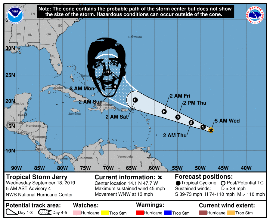
Jerry's the reason Karen is so heavily sheared in part. I thought Jerry was gonna be way past Bermuda by now. What's holding it up?
-
2019 Atlantic Hurricane Season
Floydbuster replied to AfewUniversesBelowNormal's topic in Tropical Headquarters
Almost all the models take this system straight back west under the monster ridge.
-
They don't seem that enthusiastic about Jerry, mostly because the models don't seem to be either.
-
2019 Atlantic Hurricane Season
Floydbuster replied to AfewUniversesBelowNormal's topic in Tropical Headquarters
By all accounts, things are gonna be very active in the next few weeks. We'll see if Karen and Lorenzo make their way off Africa before that wave season shuts down. -
This thing has really blown some nice convection this evening.
-
2019 Atlantic Hurricane Season
Floydbuster replied to AfewUniversesBelowNormal's topic in Tropical Headquarters
This year's ridging just doesn't seem as strong as we've seen in the last couple of seasons. This is why storms like Dorian, Humberto and now possibly 97L do the whole "slow down" and "stalling" stuff. There isn't enough of a dominant pushing ridge. -
2019 Atlantic Hurricane Season
Floydbuster replied to AfewUniversesBelowNormal's topic in Tropical Headquarters
The GFS shows a dynamic outflow setup over the Bahamas/Straits prior to Florida landfall. That's probably why the dramatic intensification. Or the model is on crack. -
Because when I thought the ridging would break down during Frances and Ivan and Dean and Felix and Ike and Irma...the ridging was stronger than the models depicted. So when the models showed ridging so strong Dorian got to the panhandle, I thought "Perhaps they're underestimating again and Dorian will head even further west than that."
-
2019 Atlantic Hurricane Season
Floydbuster replied to AfewUniversesBelowNormal's topic in Tropical Headquarters
Most of the hurricane seasons I tracked as a kid or teen wouldn't have activity until late September and October. Hurricane Keith October 2000, Hurricane Iris October 2001, Hurricane Lili October 2003, ect ect. If the climate models are correct, we could have some activity during this time. -
I can't believe the failure of computer models this past month. I'm not just speaking about this Dorian situation, I'm speaking about how 10 days ago the models showed us ending August with 0 tropical storms, and in the last ten days, we had two storms, one hurricane, and one hurricane of 150 mph bearing down the Bahamas. I almost think that "phantom storms" on the old models 10 years ago atleast gave us an idea of upcoming activity. I remember the long-range GFS continuously showed a long-tracked hurricane coming off Africa for weeks. One would hit New England, one would hit Mexico, one would hit Miami. That phantom on the model eventually became Hurricane Dean.
-
2019 Atlantic Hurricane Season
Floydbuster replied to AfewUniversesBelowNormal's topic in Tropical Headquarters
Yeah the EURO and GFS Legacy are showing a tropical wave interacting with disturbed weather in the SW Caribbean taking a track similar to Dolly '08 or Harvey and becoming a Western Gulf hurricane in the next 7-10 days. -
2019 Atlantic Hurricane Season
Floydbuster replied to AfewUniversesBelowNormal's topic in Tropical Headquarters
Yeah, the reason the GFS models bomb this into a beast is because of an amazing amount of outflow channels it gets near the Bahamas. One off to the north, one to the southeast into an upper level low, and another one into an upper low feature in the Gulf of Mexico.
-
2019 Atlantic Hurricane Season
Floydbuster replied to AfewUniversesBelowNormal's topic in Tropical Headquarters
GFS makes this a strong hurricane but recurves just before it would impact the Southeast U.S. -
In all fairness, if it was one month later with a building ridge to the north, we'd be in a heap of trouble.
-
2019 Atlantic Hurricane Season
Floydbuster replied to AfewUniversesBelowNormal's topic in Tropical Headquarters
Please stay west! I have a Myrtle Beach vacation this upcoming weekend -
So since I'm more a tropical guy than anything else, is there a legit reason why this weather has been ball-sucking cold? It's 55 and rainy in the middle of freaking June. I'm pissed as is every other freaking person I know. If memory serves, we also had a cooler early Summer in 2017 and 2018. The only fascinating thing is if their is a correlation between cold summers in Ohio and more hurricane landfalls in the U.S? I recall August 2004 being very cold here, right before the epic reign of Charley/Frances/Ivan and Jeanne.