

Floydbuster
-
Posts
3,045 -
Joined
-
Last visited
Content Type
Profiles
Blogs
Forums
American Weather
Media Demo
Store
Gallery
Everything posted by Floydbuster
-
Santa Domingo getting lashed pretty hard with gusts and rain via twitter videos.
-
I will say, Southeast Florida has been extremely lucky. Frances could've rolled right into Miami as a Cat 4, instead it sputtered, weakened and sloshed ashore much further north. Had Katrina had an extra 24 hrs over the Bahamas, it would have been a major hurricane over Fort Lauderdale. Matthew just grazed Southeast Florida as a late season Cat 4, and Irma took that south dive into Cuba and the Keys. To say nothing of Dorian, which stopped just offshore West Palm Beach as a 180 mph storm.
-
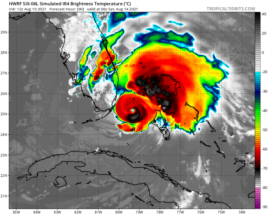
12z HWRF shows a tightly coiled powerful hurricane nearing Miami
-
Looks like some tropical storm force winds and a closed LLC. Not the best defined and I'd like to see lower pressures, but I'd go ahead and give it a name. (and I'm conservative when it comes to naming)
-

2021 Atlantic Hurricane season
Floydbuster replied to StormchaserChuck!'s topic in Tropical Headquarters
Matt, I believe the wave you mention is the same one many of the long-range ensembles show as a potential storm system in the Caribbean or Gulf down the road. -
That HWRF puts a 973 mb hurricane over Biscayne Bay.
-
Yeah. 983 mb.
-
2021 Atlantic Hurricane season
Floydbuster replied to StormchaserChuck!'s topic in Tropical Headquarters
The long-range ensembles show a flurry of activity right on time in late August. -
Here's an 11:30pm video update on PTC 6
-
Look at that beautiful anti-cyclone right over the top of it.
-
2021 Atlantic Hurricane season
Floydbuster replied to StormchaserChuck!'s topic in Tropical Headquarters
I definitely think we could see a tropical storm out of this. The longer-range ensembles seem to like the wave leaving Africa this week as a potential Caribbean cruiser and much stronger. We're getting closer to the active times for sure. -
2021 Atlantic Hurricane season
Floydbuster replied to StormchaserChuck!'s topic in Tropical Headquarters
I'm kinda surprised that the NHC is so liberal with development. I'm not convinced anything will come of either area of interest. I'm also not impressed with the long-range models but they seem to be awful on genesis. Two years ago, the long-range GFS a few days out showed a sunny beautiful day in Abaco Island when it actuality there was a 180 mph hurricane overhead. Last year, the models showed nothing of a 90 mph Hurricane Hanna slamming into Texas. I have little faith with the forecast models when it comes to genesis. -
2021 Atlantic Hurricane season
Floydbuster replied to StormchaserChuck!'s topic in Tropical Headquarters
Interesting as the last two storms named "Fred" in 2009 and 2015, were far, far out in the Eastern Atlantic near the Cape Verdes. Hurricane Fred - 2009 Hurricane Fred - 2015 -
2021 Atlantic Hurricane season
Floydbuster replied to StormchaserChuck!'s topic in Tropical Headquarters
I'm intrigued for Texas. -
2021 Atlantic Hurricane season
Floydbuster replied to StormchaserChuck!'s topic in Tropical Headquarters
Disturbing that nearly every blob hits the United States. -
2021 Atlantic Hurricane season
Floydbuster replied to StormchaserChuck!'s topic in Tropical Headquarters
Interesting discussion. I was reading about "return periods" for intense hurricanes here: https://journals.ametsoc.org/doi/full/10.1175/2007JCLI1772.1 They make an interesting discussion about the rarity of a sub-900 mb landfall in America, using the 1935 Labor Day Storm as their example. Using their models, we should be coming up on a sub-900 mb U.S. landfall within the next decade or two. I can definitely imagine a tightly-coiled pinhole eye sloshing ashore in Padre Island. Hurricane Anita 1977 comes to mind as a very close call. Without extra push from the high pressure to it's north, Anita would have made landfall as a 175 mph Category 5 in South Texas. -
I don't get the Guillermo reference?
-
2021 Atlantic Hurricane season
Floydbuster replied to StormchaserChuck!'s topic in Tropical Headquarters
I never thought I'd become an old-fogey to where I actually believe we name too much or retire too much. -
This weather has been awful and depressing. I feel like I live in an old Soviet town.
-
2021 Atlantic Hurricane season
Floydbuster replied to StormchaserChuck!'s topic in Tropical Headquarters
Don't post too many videos. They'll end up naming the Upper level low "Fred". -
I try. I will say this year I think Florida may be smacked pretty hard. I tend to notice that seasons with abnormally cold springs here in Ohio result in disastrous major hurricane landfalls in Florida. 2004 and 2017 come to mind.
-
New Video on Hurricane Elsa https://www.youtube.com/watch?v=-4Czm7j8iE0
-
Doesn't look like a hurricane, but it definitely looked good earlier. Still better looking than Hurricane Barry 2019.
-
-
I think Elsa landfalls further east. I'm gonna guess well south of the big bend.


