Floydbuster
-
Posts
3,045 -
Joined
-
Last visited
Content Type
Profiles
Blogs
Forums
American Weather
Media Demo
Store
Gallery
Everything posted by Floydbuster
-
I haven't trusted the EURO since it showed Irma making a landfall in downtown Miami for a week straight.
-
Wow! Impressive totals. Once you get 10+inches, it's chaos!
-
Oh yes. I remember now pushing my dad's Mitsubishi eclipse through insane snow.
-
Refresh my memory? What was the monster '08?
-
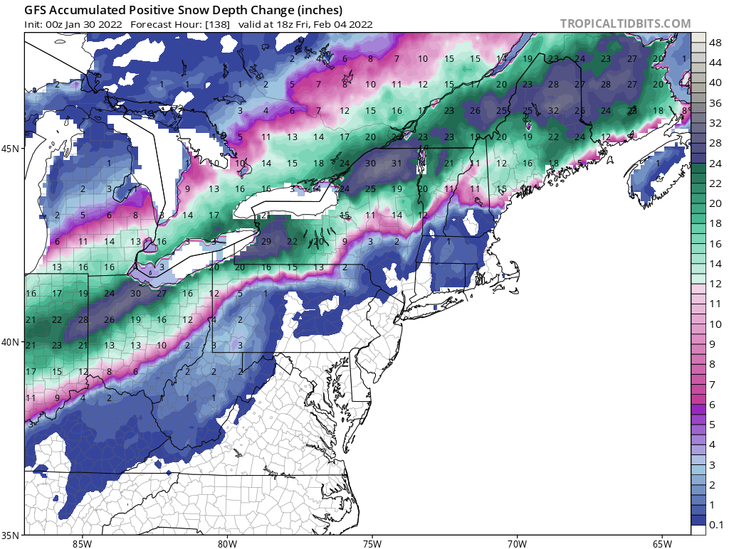
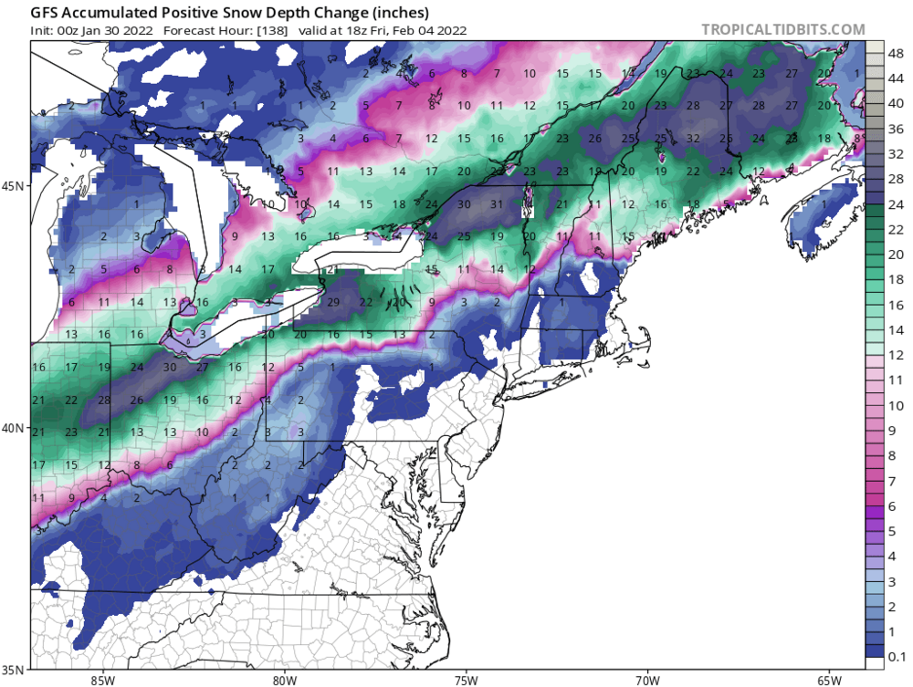
Can you post that map for the Cleveland/Akron area, please?
-
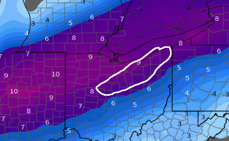
I need a southward shift on that map to my vicinity.
-
Can you translate that?
-
Here we go Northeast Ohio
-
Wow. 16 inches near Akron, and near 30 inches near Toledo.
-
Well I'm close to Akron so I want a south trend! lol
-
I'm in Stow. We got about 20 inches a couple weeks ago. Another 12-15+ would be amazing.
-
Am I reading that correctly? 30 inches in Northern Ohio?
-
Holy crap. What day would the worst be?
-
Local Northeast Ohio Facebook friends keep sharing model maps of 10-15 inches of snow for Cleveland/Akron in a week. Are they getting too hyped?
-
My girlfriend lives in North Royalton and said the roads are awful.
-
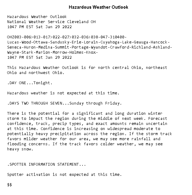
The NWS here in Summit just issued a Hazardous Outlook. Hazardous Weather Outlook National Weather Service Cleveland OH 158 PM EST Sat Jan 22 2022 OHZ003-006>011-013-018>023-033-PAZ003-231900- Lucas-Wood-Ottawa-Sandusky-Erie-Lorain-Cuyahoga-Geauga-Seneca-Huron- Medina-Summit-Portage-Trumbull-Mahoning-Crawford- 158 PM EST Sat Jan 22 2022 This Hazardous Weather Outlook is for north central Ohio, northeast Ohio, northwest Ohio and northwest Pennsylvania. .DAY ONE...This afternoon and tonight. A clipper system will bring widespread light snow for northern Ohio into northwest Pennsylvania late tonight into Sunday. 1 to 3 inches of snowfall is possible for much of the area. .DAYS TWO THROUGH SEVEN...Sunday through Friday. A clipper system will bring widespread light snow for northern Ohio into northwest Pennsylvania through Sunday evening. 1 to 3 inches of snowfall is possible for much of the area. .SPOTTER INFORMATION STATEMENT... Spotter activation is not expected at this time. $$ My area is forecast 1-3 Sunday and 1-3 Monday. So here's looking at 2-6 inches by Monday night!
-
Wow. Didn't get a fraction of that much here in Stow.
-

Winter 2021-22 Short/Medium Range Discussion
Floydbuster replied to Chicago Storm's topic in Lakes/Ohio Valley
Is that snow in NE Ohio expected to come in the forum of any particular storm? -
Since I'm more a tropical weather guy, I'm a little out of the loop. Can someone give me a rough idea of the next big snow blast coming for Northeast Ohio? The rumors around town are in a week and a half there's "another big one coming".
-
I received about 17-20 inches in the Stow area.
-
NHC Hurricane Specialist Stacy Stewart Retires
Floydbuster replied to hlcater's topic in Tropical Headquarters
I wish him the best in retirement! His discussions were my absolute favorites. Cool guy too, he was very nice when I met him back in '05.
-
Some of the damage out of Mayfield, KY looks easily EF-4 or EF-5ish. Awful.
-
2021 Atlantic Hurricane season
Floydbuster replied to StormchaserChuck!'s topic in Tropical Headquarters
https://www.noaa.gov/news-release/active-2021-atlantic-hurricane-season-officially-ends Hurricane Season 2021 officially over and in the record books. I think this was a very memorable season, mainly because of the 150 mph landfall of Hurricane Ida along the Louisiana coastline. Those type of Gulf Coast landfalls are rare, despite three in the last few years. (Michael, Laura, Ida) I think those of us who have been tracking hurricanes for decades know that most seasons are made memorable because of only one or two storms. 2002 had Isidore and Lili. 2003 was Fabian and Isabel. I think there is a generation of storm trackers spoiled by the likes of 2005, or 2020. Overall, this was a memorable hurricane season. Elsa and Fred could have been slightly more intense, and both could have struck Florida as hurricanes. (Remember the persistent HWRF model showing Fred crossing Biscayne Bay at 90 kt?) but Grace performed beyond expectations. I busted with Henri, which I thought would be much more damaging to New England, but thankfully it wasn't. Ida takes the cake as the storm of the year although (stupid point) I wish it had been named "Hurricane Julian". Larry and Sam were beautiful but out to sea. I'm still surprised Sam's ACE ended up so high. Very impressive. Hurricane Nicholas was a nasty little thing but already seems forgotten. Overall, a memorable season. I still think I myself am partial to the long-tracked threat seasons. Think Frances/Ivan 2004 or Irma 2017. -
I'm admittedly a climate change skeptic, atleast when it comes to meteorology and hurricanes. But I have to say, growing up during the mid 1990s in Northeast Ohio, I remember much longer springs with violent severe weather (April/May 1998 stands out in my mind) and much longer, crisper, cooler falls. Now we seem to have snow till May, absolving us of any Springtime, and then heat until Thanksgiving, giving us virtually no Fall. Unless it's just part of getting older and time going faster, it seems like we don't have many more "seasons" here in Ohio the way we did 20-25 years ago. There are also other little things I notice. We used to have a ton of blackberry bushes all over the place. Now I rarely see any. What the hell is up with that? Any thoughts? I remember lots of severe weather here in Ohio back in 1998 and 1999. The violent Ohio thunderstorms would have me flip to The Weather Channel and I'd see graphics for Hurricane Georges or Hurricane Floyd and that began my hurricane tracking.
-
My apartment is very well insulated. I've had to have the A/C running full blast and these prices are even higher than they used to be. Plus I want that crisp fall weather and I just bought a nice $400 leather lambskin jacket I can't show off.