Floydbuster
-
Posts
3,045 -
Joined
-
Last visited
Content Type
Profiles
Blogs
Forums
American Weather
Media Demo
Store
Gallery
Everything posted by Floydbuster
-

2022 Atlantic Hurricane season
Floydbuster replied to StormchaserChuck!'s topic in Tropical Headquarters
Euro ensembles definitely zero in on Florida. -
2022 Atlantic Hurricane season
Floydbuster replied to StormchaserChuck!'s topic in Tropical Headquarters
The EURO ensembles are sniffing out this little thing that just flared up north of the Bahamas. -
2022 Atlantic Hurricane season
Floydbuster replied to StormchaserChuck!'s topic in Tropical Headquarters
That's a very impressive wave leaving Africa. -
Hurricane Andrew - 30 years later
Floydbuster replied to Floydbuster's topic in Tropical Headquarters
I was always impressed by how long sustained winds were clocked. Sustained winds in most major landfalls don't last for long, and Andrew had some reports of 120-130 mph sustained for 10 minutes+ until instruments failed. -
Hurricane Andrew - 30 years later
Floydbuster replied to Floydbuster's topic in Tropical Headquarters
Yeah, hard to believe Michael's pressure was lower than Andrew. At the same time though, Andrew had very high background pressure. Funny thing though, it was clearly going to continue to deepen had it not struck Florida. My guess is that it might have gotten close to sub-900 mb. Makes me wonder if Andrew '92 was the return period storm for the '35 Labor Day hurricane. -
It's been 30 years since the Category 5 storm struck South Florida, and then later Louisiana as a Category 3 hurricane. Here's a little retrospective for the 30th anniversary of Hurricane Andrew. Interestingly enough, going back and reading the data, Andrew was strengthening so fast upon landfall, that in the 25 minutes between the Elliot Key landfall and the Fender Point landfall, the pressure dropped 4 mb. That's a 4 mb pressure drop in 20-25 minutes. Crazy!
-
2022 Atlantic Hurricane season
Floydbuster replied to StormchaserChuck!'s topic in Tropical Headquarters
As the 12Z rolls out (and looks scary), it is interesting that last night I noticed the Central Atlantic convection around 55W getting slightly better defined. Noticing some ever-so-slight turning if you use your imagination. -
2022 Atlantic Hurricane season
Floydbuster replied to StormchaserChuck!'s topic in Tropical Headquarters
We somehow lost a big dump of fantastic meteorological threads. It is such a shame all that historical discussion is gone. Sure, there were plenty of bad takes. But we were frequented by some really good experts and mets, and blessed a plethora of knowledge. Maybe someone can help, on a somewhat unrelated note, my entire browser is full of ads anytime I'm on this website. It didn't use to be like that. Is that normal? I can't even get to my "quote" box in the bottom right-screen.
-
Wake me when it crosses 60W.
-
2022 Atlantic Hurricane season
Floydbuster replied to StormchaserChuck!'s topic in Tropical Headquarters
Yeah once you see those tight closed isobars on a long-range model, that likely indicates a much stronger storm. So if the hurricane into SE Florida is "964 mb" that could actually be something more like a Cat 3/4. -
Looks like Danielle lives to see another day this season.
-
2022 Atlantic Hurricane season
Floydbuster replied to StormchaserChuck!'s topic in Tropical Headquarters
That setup is very dangerous for the SE US coast. -
2022 Atlantic Hurricane season
Floydbuster replied to StormchaserChuck!'s topic in Tropical Headquarters
Good grief. 384 hrs but still. Frances anyone?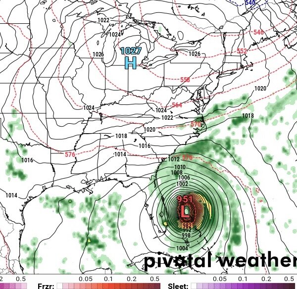
-
2022 Atlantic Hurricane season
Floydbuster replied to StormchaserChuck!'s topic in Tropical Headquarters
That's just not true at all though. In 1999, we didn't get Hurricane Floyd or Hurricane Irene or Hurricane Lenny until Sept 13th. In 2000, it was October 1st when we had three developing hurricanes (Isaac, Joyce and Keith). Those are two of todays analog years. La Nina years have more active September and Octobers. -
2022 Atlantic Hurricane season
Floydbuster replied to StormchaserChuck!'s topic in Tropical Headquarters
Yeah in that run, it misses the weakness and ends up trapped with rebuilding heights above. -
Looks great.
-
2022 Atlantic Hurricane season
Floydbuster replied to StormchaserChuck!'s topic in Tropical Headquarters
Each year looks essentially the same to me. -
2022 Atlantic Hurricane season
Floydbuster replied to StormchaserChuck!'s topic in Tropical Headquarters
The NHC doesn't have a lemon because the wave that is likely to form isn't necessarily the one leaving Africa now, it's probably the one following behind. Nevertheless, the consistency of the long-range ensembles show the lid peeling off. -
2022 Atlantic Hurricane season
Floydbuster replied to StormchaserChuck!'s topic in Tropical Headquarters
12Z GFS showing a powerful hurricane striking North Gulf Coast around August 28th.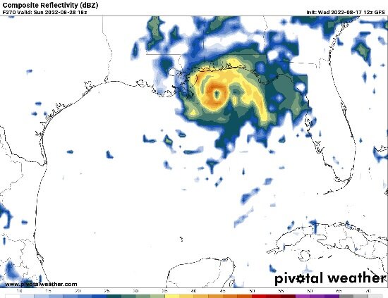
-
2022 Atlantic Hurricane season
Floydbuster replied to StormchaserChuck!'s topic in Tropical Headquarters
I remember in 2000, the only coverage of Cat 4 Hurricane Keith offshore Belize was a blurb on CNN and the tropical updates on the Weather Channel. Nowadays, you have CNN articles about 384 hour GFS models. Katrina changed everything. Pre-Katrina, you would have never seen a news article about an obscure long-range weather model. -
2022 Atlantic Hurricane season
Floydbuster replied to StormchaserChuck!'s topic in Tropical Headquarters
The O0Z GFS showed three hurricanes off Africa, lined up like a train. Some of the ridging setup looks potentially dangerous for the SE US coast in some of the long-range runs. Take with a grain of salt, but still. -
Another day over water and this would have been Danielle.
-
2022 Atlantic Hurricane season
Floydbuster replied to StormchaserChuck!'s topic in Tropical Headquarters
I was gonna say, I see Danielle, Earl and Fiona by August 28th per the 12Z GFS. -
Invest 97L--10% 2-Day/10% 5-Day Development Odds
Floydbuster replied to WxWatcher007's topic in Tropical Headquarters
Nah it's not gonna be a dud season. Alot of these youngsters have been spoiled by 20 named storm swirls by July 15th. I'm an old timer. (compared to them) I remember tracking the 2nd named storms "Bonnie" and "Bret" in '98 and '99 and they were still weeks away from where we are now. Plus, just 24 hrs ago, the GFS was showing a hurricane scraping the East Coast and then another hurricane headed for the Lesser Antilles. Yeah it dropped it, but still a sign of things to come.