weathertree4u
-
Posts
974 -
Joined
-
Last visited
Content Type
Profiles
Blogs
Forums
American Weather
Media Demo
Store
Gallery
Everything posted by weathertree4u
-

TN valley heavy rain/flooding week of whenever
weathertree4u replied to janetjanet998's topic in Tennessee Valley
Not good, not good at all -
Well, there is always next year; cant wait for the early predictions to start coming out in the July/August time period; just hope that we can, as someone already stated, that we do not have the misfortune of having an early season tropical system.
-
TN valley heavy rain/flooding week of whenever
weathertree4u replied to janetjanet998's topic in Tennessee Valley
CFS seems bring heavy rain back to region through March -
TN valley heavy rain/flooding week of whenever
weathertree4u replied to janetjanet998's topic in Tennessee Valley
That has been trend though -
TN valley heavy rain/flooding week of whenever
weathertree4u replied to janetjanet998's topic in Tennessee Valley
Personally speaking, I do not think that the current time period will be the big issue. Heading into the Spring, I feel like we are in a bad place. North of Nashville we got close to 4" yesterday evening which, of course, as in the East TN area, flash flooding. We need a large scale pattern change, I mean large scale. I dont want a drought but seems like we are over due for one! -
Yea, won't take much blow allot timber down
-
TN valley heavy rain/flooding week of whenever
weathertree4u replied to janetjanet998's topic in Tennessee Valley
That has been trend though -
TN valley heavy rain/flooding week of whenever
weathertree4u replied to janetjanet998's topic in Tennessee Valley
Just do not honestly see how this has a good ending no matter how it plays out over the next week -
TN valley heavy rain/flooding week of whenever
weathertree4u replied to janetjanet998's topic in Tennessee Valley
Something off the modeling this Winter or maybe it is just me or a little of both. -
TN valley heavy rain/flooding week of whenever
weathertree4u replied to janetjanet998's topic in Tennessee Valley
Exactly! That is what I am concerned about. Personally moved from winter tracking a few days ago but knowing what I know about Spring in the TN Valley, we could be entering uncharted territory. For example, last Spring, the area just to the north of where I am got 5"- 6" of rain in a thunderstorm - May I believe - within a half hour, the large creek near me - Upper Station Camp, that flows into Old Hickory Lake - was out of its banks. Now, throw that same storm into the area this May and I honestly do not know what would happen! -
TN valley heavy rain/flooding week of whenever
weathertree4u replied to janetjanet998's topic in Tennessee Valley
I thought that I saw someone posting in here yesterday that they saw a pattern change in the extended. I am not seeing it, am I looking in the wrong place? By end of the week, I would think the region would be uniquely positioned to be experiencing flooding, not sure we are to 2010 levels yet but we have got to be getting close. -
The amount of rain for the month being depicted by the CFS is nothing short of amazing
-
Mid to Long Term Discussion 2019
weathertree4u replied to Upstate Tiger's topic in Southeastern States
Not unless the pattern shifts dramatically pretty soon! Looks like it is all GLC for foreseable future. -
I was thinking the same thing. I dont follow the stuff as closely as some in the forum but could tell yesterday early on that things in reality were not modeled correctly. Was a great air mass but could have used a little rain!
-
Excellent point. The physics behind the models I know is way over my head, simply amazing that we can take an educated guess at it at all. Plus when you factor in the things that probably are not factored in like low solar and continued volcanic activity, heck, we might as well flip a coin!
-
Which is generally why the weather is just so fascinating. Not sure whether we will ever develop the capability to forecast much better than we are now honestly!
-
Have been seeing some brief mentions for next Winter for a El Nino Modoki, is this an indication of that as well and or what are your thoughts?
-
MO/KS/AR/OK 2019-2020 Winter Wonderland Discussion
weathertree4u replied to JoMo's topic in Central/Western States
Usually just lurk in your forum but cannot resist posting! We are the same way really in the TN Valley, though, we have gotten more snow this year than in the previous couple. Still, I am left wondering why it is so hard to get one or two of those "I-40" specials like I remember as a kid in the late 1970's and 1980's? The good ones that give everyone 5" or 6" and melt away in two days? We got 3" or so last Friday plus the 3" - 4" we just got. Snow is really becoming an issue for me since we have an inability to keep the side streets clear. I am fine with a snow that is gone in a couple of days, not so much snow that hangs around for close to a week! -
Historic Tennessee Valley Cold, Snow, and Ice Events
weathertree4u replied to Carvers Gap's topic in Tennessee Valley
I remember that one well. Allot of places on the Highland Rim were without power for two weeks or more. Even today, when driving through the area, it looks like all the trees in the woods were pruned back, now about 15' down. The real problem with that storm was that after the front pushed through early that morning, the wind picked up out of the northwest which was the final blow for allot of the trees. It was a nightmare for sure. -
Historic Tennessee Valley Cold, Snow, and Ice Events
weathertree4u replied to Carvers Gap's topic in Tennessee Valley
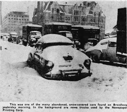
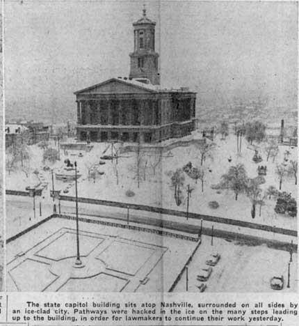
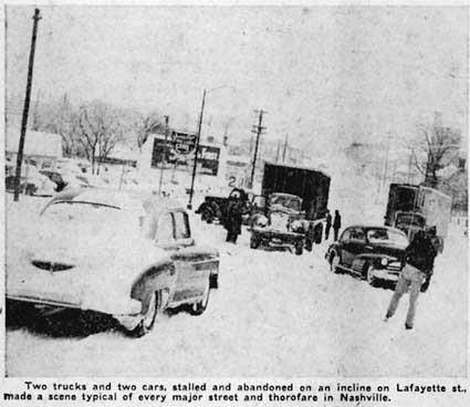
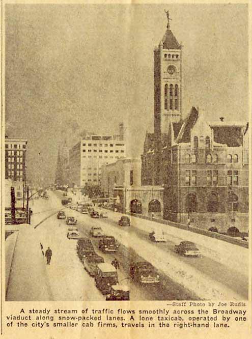
Honestly, one would think that forum members do not go through this every year! Even some of the historically awesome winters that Nashville has had have had warm spell. I do not know if these are analogs for our current winter but they re-affirm my point that sometimes, it is warm during the winter but sometimes, as in 1951 and 1963, you are within a week or two of some pretty awesome winter weather. From 01/17/1951 - 01/20/1951 Nashville was well into the mid and upper 60's I am sure people were thinking winter was over. Here are a couple of entries from the weather records for the end of the month... 01/29/1951 - The worst ice storm in Nashville's history begins, causing a complete stalemate of transportation in Nashville for two days. Frozen precipitation starts during the evening, with 1.6" of snow and ice accumulating by midnight 01/30/1951 - Five inches of snow and ice fall, much of it during the evening, producing a water equivalent of 3.83". This is the greatest one-day precipitation event for January in Nashville's history. 02/01/1951 - Precipitation continues at Nashville through the morning, most of it as snow, and finally ends around noon. An additional 5.2" are measured, leaving the city buried under 8" of ice and snow. 02/02/1951 - Temperature at Nashville drops to -13, tying the record low for the month. Consider January 1963. From 01/09/1963 - 01/11/1963 Nashville was well into the 60's and very mild until 01/23/1963. 01/10/1963 - An F3 tornado touches down at Spring Hill (Maury County) just before midnight. The twister cuts a 4 mile path, lifting at Bethesda (Williamson County), after causing 4 injuries. 01/23/1963 - The strongest cold front in mid state history brings heavy snow and an unprecedented drop in temperature. Nashville receives 6.2" of snow. In addition, the high temperature reaches 48 degrees, but plummets to -13 degrees by midnight, for a range of 61 degrees. This is the greatest daily range of temperatures in Nashville's history. 01/24/1963 - Temperature at Kingston Springs drops to -30 degrees, which is the lowest temperature ever recorded in Middle Tennessee, and comes within 2 degrees of tying the all-time record low for Tennessee (Mountain City, 12/30/1917). Other record lows include Clarksville (-17), Dover (-24), Lafayette (-20), Linden (-18), Portland (-19), Springfield (-18), and Waverly (-26). In fact, Waverly sees its temperature drop by 80 degrees with the passage of the strongest cold front in mid state history. Five inches of snow accompany the dramatic change in temperature. The Duck River freezes solid from bank to bank for the first time since 1898. Harbors along the Tennessee River also freeze. It is considered the worst winter weather since the 1951 ice storm. http://www.weather.gov/ohx/calendar I have also attached some pix from the January 1951 storm in Nashville