Uncle Nasty
-
Posts
285 -
Joined
-
Last visited
Content Type
Profiles
Blogs
Forums
American Weather
Media Demo
Store
Gallery
Everything posted by Uncle Nasty
-
 Moderate snow at 10:45 in Ooltewah. Measuring snow hourly on board. .75 1st measurement at 9:28 10:25, the 2nd measurement received additional .75". No melting yet, and board is 1.5" on the side I'm not scraping off. I'm doing a fresh scrape every hour. My wife.said NO to drivjng her Gladiator if I decide to play. Bought my Jeep new in August and haven't upgraded my tires yet. Waiting to see if snow can get at least 3" deep on roads before driving. I pulled the Jeep out the driveway earlier, and it was compact ice instantly under the snow when I was backing it up the driveway. It's beautiful outside. I hope the grass is covered completely within the hour. On a side note, Accuweather forecast is blowing out some high totals for the area. They show 6-10 for Chattanooga. I'm not sure that's possible. What caught my attention is they have Dunlap at 8-12. We recently bought 4 acres on Lewis Chapel Mountain with brow view. If Dunlap manages to get 8" or more, I can only imagine how much the surrounding mountains will get. Is there anyone here from that area that can give a report? Sent from my SM-S916U using Tapatalk
 -
You work across the street from me. [emoji51] Sent from my SM-S916U using Tapatalk
-
I can't load anything using the website. When I use Tapatalk, it allows me to post pictures. Even a small picture on the website tells me they file is too large. Works fine on Tapatalk. Sent from my SM-S916U using Tapatalk
-
CBS local Chattanooga said snow has started on Broad Street downtown Chatty. Should I move this post to observations and not post here ?
-
I'm flipping channels between several cities. Alabama has extended their warning further south. Just took this live video off the TV from Birmingham ABC. Well file is too large to load. Reports of 3" on the ground near Birmingham in Jefferson County
-
I just walked outside. There is nothing yet, but it has a snow feel to it. Cold, but comfortable. And it has that snow smell as well. It's close to kickoff. Sent from my SM-S916U using Tapatalk
-
Is someone in Morristown trolling us? Surely this is a computer error. Edit to add: Just now catching up and noticed I wasn't the only one with issues. [emoji28]
-
Local NBC forecast looks almost identical to last January. They went from 4-8 at their 6 o'clock broadcast all the way down to 1" with up to 6" north of town. That's disheartening if it works out this way. Edit to add: That would be 1" more than last year when I had 33° and a rain/mix to drizzle.[emoji28]
-
Hey, who's this guy? Welcome back!
-
If we get a repeat of last January in Ooltewah, I'm going to go kick the neighbor's dog, and I love that dog. In all seriousness, we're right on the fringe of misery or a big banger in the transition zone of snow. Soddy Daisy scored last year. Let Ooltewah and East Brainered get ours this year. I read one article if the dynamics are right, someone under a heavy band in or around Chattanooga "could" witness some thundersnow. We need to keep it all snow.
-
Here's a good read from the NWS in Peachtree City. The wording looks like they did a collaboration with Morristown and Birmingham offices. https://forecast.weather.gov/product.php?site=FFC&issuedby=FFC&product=AFD&format=CI&version=1&glossary=1 Sent from my SM-S916U using Tapatalk
-
[emoji1] [emoji1] I would if I didn't have to wake every morning at 3:45 to drag myself into VW. We moved to Ooltewah in June of 2016. Biggest snow was February 2020. 3 inches at 8am that was completely melted off by noon. Add all other snows together, we "might" have a 2-3" total in 8 years. We're due. Sent from my SM-S916U using Tapatalk
-
I need to start going to bed earlier. The models seem to back off at night before I go to bed. I wake up for work to see an increase. When I read the forecast discussion, I had a "WOW" moment. I honestly woke up expecting to see less than 1" in the forecast with mostly a mix. Good stuff. Sent from my SM-S916U using Tapatalk
-
Woke up for work at 3:45. Just taking a look at everything. Wow. [emoji102] I was confused on the Morristown update. They have increased their confidence with heavier snow it would seem. In the same paragraph they mention less QPF reaching the area showing on models.They were touting more snow, as in 2-6" a good possibility, but with less QPF, talking it down in the next sentence. I'm guessing they're counting on higher ratios but less QPF with their wording. Sent from my SM-S916U using Tapatalk
-
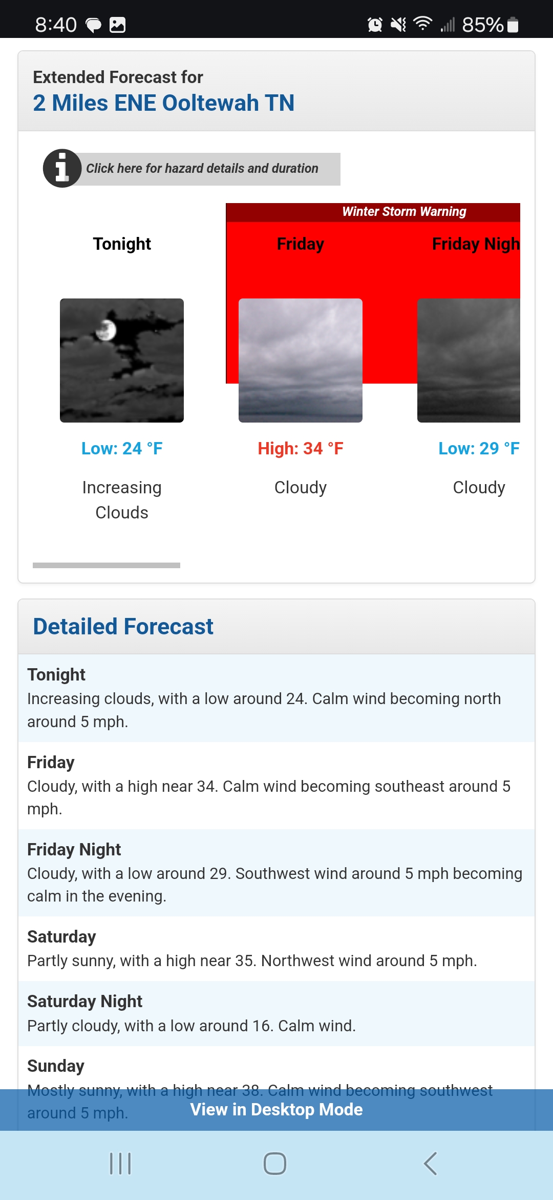
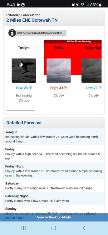
5 days out, I'm surprised Morristown is even mentioning amounts. That's a possible good sign. They do have Chatty with the possible dreaded WAA. Area Forecast Discussion National Weather Service Morristown TN 333 AM EST Mon Jan 6 2025 Discussion: .LONG TERM... (Tuesday through Sunday) Issued at 254 AM EST Mon Jan 6 2025 Key Messages: 1. Cold temperatures continue through the week. 2. No significant weather through Thursday night. 4. Another good chance for wintry precipitation Friday afternoon through Saturday. Discussion: Cold arctic airmass behind todays frontal system will remain locked in across the area this week, generally running 10 degrees below normal or more with no locations after today through Friday above 40 degrees. Nighttime lows will be mostly teens to lower 20s with skies mostly clear and winds lighter through early Thursday night. A zonal flow aloft will keep the middle of the week period fairly quiet. Weak systems to the north may bring some clouds to southwest Virginia and extreme northern Tennessee Tuesday night and Wednesday night but no precipitation expected. Thursday night the pattern changes as the next southern system begins to develop. On Tuesday over the southern Rockies a surface low pressure and an upper level low begins developing over northern Mexico and begins to spread precipitation across the desert southwest and west Texas Wednesday. The system continues to develop Thursday with gulf moisture then spreading into the lower Mississippi Valley. The ECMWF has the system more developed than the GFS Thursday. Both models keep surface low along the coast Thursday night and Friday. A good southwesterly flow aloft will bring the moisture northeast into the Tennessee Valley Friday. GFS/NBM brings a significant 2 inch or so snowfall for the Tennessee Valley and several inches for the higher elevations especially across the Smokies lasting through the day Saturday, but ECMWF model keeps the heaviest precipitation along the Gulf Coast and much lighter snowfall farther north across the CWA Friday night and Saturday morning. Models keep temperatures cold in the 30s Friday as the moisture moves in with slightly warmer temperatures Saturday and Sunday. Sunday clouds decrease with the precipitation ending. Any winter precipitation that falls through Saturday may keep high temperatures down even with the sunshine. Will have to watch later model runs to see if more agreement happens with the threat for significant snow or if the system will stay farther south on the Gulf coast. Also as a southwest flow develops out ahead of the system and if it slows down its eastward movement temperatures may warm more than forecast reducing potential snowfall amounts. Sent from my SM-S916U using Tapatalk
-
A lot of the snow maps being posted on various forums look beautiful for my area,, but as usual, I'm keeping my expectations low for the simple fact that WAA can destroy a good snow in Chattanooga. It happened last January. We were 33° with a mix before turning to all rain. Across the Tennessee river and points north got hammered with snow. We were 8 miles away from a 2" minimum snow where the rain/snow line cut off. Portions of north Hamilton County received 8" and even more as you go up the mountains around Dunlap. The thing about Chattanooga is that we might go 5-10 years with minimal snow, but when we do score, it's normally on the extreme high levels. Here's to hoping this could be one of those extremes! Sent from my SM-S916U using Tapatalk
-
I know it's just a computer generated forecast, but TWC app has a chance of rain/snow all around the Chattanooga area next Friday with their standard "Watching a potential winter storm" to go along with their basic forecast. Same wording in Dalton. Ga. Knoxville, Dunlap, Tn., etc. Let's see where this takes us. [emoji848] Sent from my SM-S916U using Tapatalk
-
Same here on Tapatalk. The most recent pinned post is December. Sent from my SM-S916U using Tapatalk


-
February 2024 mid/ long range
Uncle Nasty replied to Holston_River_Rambler's topic in Tennessee Valley
Weather Channel app is picking up on something in that time frame for our area with snow, rain, and freezing rain around the 19th. Posted earlier but had a typo fat fingering the date. Hopefully, the southern valley near Georgia border can actually get some white on the ground. Sent from my SM-S916U using Tapatalk- 750 replies
-
- 2
-

-
- snow elk
- wooly worm
- (and 1 more)
-
I'm happy for everyone. It was amazing the difference of a few miles in the Chattanooga area. I'm in Ooltewah where we might have received 1/4" of snow. 6 miles to our north started the accumulating snowfall. 2" and then higher totals of 6-10. All the snow was north and east of us 6 miles. Maybe 8 miles away in Harrison near the lake 4" was widespread. We received the warm nose shaft here. Oh so close. Sent from my SM-S916U using Tapatalk
- 372 replies
-
- 5
-
-
- cold
- arctic blast
- (and 1 more)
-
January 15th-17th 2024 Arctic Blast/Snow Event
Uncle Nasty replied to John1122's topic in Tennessee Valley
Off topic a little, but we are thinking about having lunch at Turkey Creek. Watching all the local Knoxville Tv stations today, it looks like the interstate is fine driving north on 75. I'm just curious if anyone here has any local knowledge if anything is open. I've already called Smoky Mountain Brewery and Connors. I can't get anyone on the phone, which tells me they are probably closed and haven't updated their message. I am really wanting a T Rex pizza. Sent from my SM-S916U using Tapatalk -
January 15th-17th 2024 Arctic Blast/Snow Event
Uncle Nasty replied to John1122's topic in Tennessee Valley
I know ya'll will think I've lost my mind for saying this , but on my couch in my peripheral vision , I thought I saw a flash of light out of the south/southeast facing window in my house. I wrote it off as a light from Miller Industries up the ridge behind me. I kept looking, and 1 or 2 minutes later, I saw it again. I saw it 1 more time after that a minute later. It was a purplish/greenish color. I don't think there's any way it could be lightning, but I have no clue what else it could be. We are currently sitting at 28° and freezing rain. On the other side of Miller is interstate 75, so I have no clue what it could have been other than a few lightning strikes. I walked outside on the patio and filmed for a few minutes, and of course, nothing else happened. I will say the ground is now a sheet of ice, and the trees are glistening. Is it possible there was enough energy in the area to have a few strikes of lightning, or am I losing my mind? On a side note, I considered a blown transformer, but it was too high in the sky to be that. Thoughts? Edit to add: I added a screenshot of the radar at the time I saw it. It "looks" like there might be something down in Georgia in the yellow area that "could" be the culprit. My weather station is showing zero lightning strikes . Sent from my SM-S916U using Tapatalk -
January 15th-17th 2024 Arctic Blast/Snow Event
Uncle Nasty replied to John1122's topic in Tennessee Valley
My buddy jn Chattanoga is a home inspector. His roofer friend posted this today. Looks like he might be a little cold in the video. [emoji51] https://www.facebook.com/share/p/xRziFt1EQACa1skZ/?mibextid=xfxF2i Sent from my SM-S916U using Tapatalk -
January 15th-17th 2024 Arctic Blast/Snow Event
Uncle Nasty replied to John1122's topic in Tennessee Valley
Like a light switch! Sent from my SM-S916U using Tapatalk -
January 15th-17th 2024 Arctic Blast/Snow Event
Uncle Nasty replied to John1122's topic in Tennessee Valley
We aren't getting it. I'm in southern Hamilton County. Everything that is white is from sleet. We've probably had 80% sleet and 20% snow. All sleet for the last few hours. I'll take a screenshot of my Ring. Everything white is sleet. Here's a picture I just took from Ring. We missed out due to mixing. Sent from my SM-S916U using Tapatalk