
Alfoman
-
Posts
182 -
Joined
-
Last visited
Content Type
Profiles
Blogs
Forums
American Weather
Media Demo
Store
Gallery
Everything posted by Alfoman
-
100% - honestly pretty similar evolution so far compared to 18Z yesterday (not identical). Could confidently say it's a less messy solution so far though day h5...
-
Definitely had some sleet mixing into the earlier bands from DC south, so that was not wrong fully. It just never was the extent the NAM had projected it to be
-
The initial phase and transfer of energy on Friday (Hour 96-ish) is what determines our fate here - especially with that lead wave. Difference between the GFS bomb runs and 0z/6z is a stronger lead SW, allowing the baja energy to stay further back southwest for longer before completing the phase with the northern stream. This results in too positive of a tilt and would likely yield a low well off-shore by the time it reaches us. Yesterday's good run had that NS shortwave leading the phase process and ending up more neutral before it hits the EC. Such a delicate dance of energies involved here...this is going to be tough to bring home.
-
12Z ICON with a similar evolution to the previous two runs - sheared and much too positively tilted to round the bend in time.
-
Definitely hitting our stride in DC proper the past hour or two with even lighter returns showing up with pretty good rates. Very fine flakes falling but still coming down pretty hard. Eclipsing 6' at the moment.
-
Around 5.25 here in Shaw - absolutely gorgeous morning out and still coming down pretty good. I'd say it was a 70/30 split between Snow and Sleet at points during the previous heavy band. You can see the faint mixing shadows on CC radar.
-
Anyone peeping the 0Z CMC
-
That was fun because we went from close to nothing to a more robust storm twice. This time we've been watching it for a week+, it's fun to know something is coming (and hurts so much more when we get the big shaft)
-
You can tell it's been a while since everyone has tracked a real dynamic storm around these parts - these model battles are half the fun. Quite literally a day ago - the GFS has the shortwave strung out and open and now we're looking at a 2 contour closed off low at H5 before the transfer to the coast. That's a considerable amount of variability within the ML evolution within a 24-36 hour window. It's going to happen. Until the CMC/Euro/Ukie camp begins to show a similar shift in regards to strength + ML warm nose - I will side with the models who have not wavered much over the last day or so versus the one playing catch up. GFS could definitely catch a win here, but there's no need to freak out about an event starting in 72 hours. Side Note: I am wondering if a couple inches up north (Metro into PA) with staying power into Sunday could help bring things down a degree or two at the sfc. I am noticing a band of slightly cooler temps along wherever the GFS sets up its maxima for tomorrow's squalls. It's slight but we'll take the help.
-
Did not see DC getting above freezing from Sunday until the end of the run...that's an impressive 10 days of winter
-

January: Medium/ Long Range: May the Force be with Us....
Alfoman replied to Weather Will's topic in Mid Atlantic
So much energy flying around out West, there's no chance the GFS truly sniffs out the UL evolution until closer to this weekend. Chess pieces in place though... -
January: Medium/ Long Range: May the Force be with Us....
Alfoman replied to Weather Will's topic in Mid Atlantic
GEM and GFS honestly relatively similar looks at 500 mb while the vort is still out west - GFS just quicker by 6-12 hours and cuts hard due to the interaction with the TPV vorticity in Canada sooner. After hour 156 though... good lord GEM has a nightmare reputation with deciphering a progressive NS like we'd have here. -
You sound like my wife
-
Way too much NS interaction too early, leads to a way more flat solution
-
Would not say it is out of the cards completely just yet - amount of members showing a secondary wave sliding off the cost doubled on the 6Z GEFS. This is a delicate balancing act between the initial low in question and the real potential right behind it. The GFS and CMC have transitioned into a quicker phase of shortwaves out west, instead of slowing things down by keeping energy dragged out in the SW. If we can slow the phase and have it dig further, generating more time for the cold to filter back in post storm #1...there could be something here. Lot has to go right here though as always.
-
Thank you ya'll for providing all the historical context for the younger millennials. I moved up to the DMV area a few years back and I am still learning all the folklore from decades-past. Sitting in the Southeast during the early 2000s-2010s periods, I felt like those smaller 1-5' inch storms were a more regular occurrence up North but those have seem to have subsided some since the 80s. Can't even get excited about a clipper potential anymore! November is always such a tough month of model watching. Nothing particularly exciting going on in the tropical Atlantic while we are stuck to speculate on the winter pattern as we enter mid to late December. The transitionary period is where I feel like the cliff jumpers start setting up their chair cliff-side - rabid Pacific doomsdayers meet long range model blocking truthers. Cheers to November
-
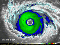
While still difficult to see on radar with attenuation preventing us from observing the west side of the eyewall clearly - it looks as if the original eyewall is already merging with the secondary maxima. It's a race against the clock on whether the storm can mostly complete the EWRC before the shear/dry air intrusion overcome the structure of the storm. I genuinely am surprised on how quickly this EWRC commenced though...
-
Absolutely agree - not blaming NOAA in the slightest, just saying I wish we did have some data coming in via recon at the moment. NOAA does the best they can given budget restraints and limited planes (plus the hazard like you said)
-
An absolute crime we don't have a plane in there right now - want to see the peak this gets to.
-
Want to relay an important caveat to all the early ensembles and models - the placement of the broad LLC will be critical in the GOM track. Regardless of whether it has a weak surface reflection at the moment, land interaction over Cuba and the mountains on the west side of the island will likely cause some re-structuring of the mid-level and low level circulation. The 12Z GFS has the broad vorticity elongated as it passes Western Cuba at 60 hours but has the LLC forming on the northern fringe of that vort - could easily see a shift by 100s of miles if that formation happens west of that spot. Anyone from LA to the FL coast should be on alert - once its go time, there's not much stopping immediate strengthening.
-
The Weekend Rule? Saturday 2/17 - The Icon Storm
Alfoman replied to DDweatherman's topic in Mid Atlantic
Not sure if we will hit below 33 until after the precip already moves out - will still be fun to watch the snow fall tonight. Just think the amp and shift north definitely made the already marginal temp situation for DC proper worse! I'll take my 1-2 and run though! -
I think the Euro evolution is our best shot to get our big (or larger) ticket storm but it is going to be a delicate solution to achieve. We really need that NS to drop down and begin the phase at the exact right moment for this to work and even if it does, the interior is favored in this kind of setup. Good news is we did see the SS dip deeper and a less noisy Eastern Canada allowing more cold air to filter in but Euro much more aggressive with that TPV lobe. Even with a +NAO in place, with all that energy rotating around in Canada, we could see a phased storm time itself correctly as long as we can get the STJ to actually produce a potent wave or two instead of that sheared flat shit it keeps throwing our way.
-
The Weekend Rule? Saturday 2/17 - The Icon Storm
Alfoman replied to DDweatherman's topic in Mid Atlantic
For once this season, we got the dreaded north + warmer trend within the final hours... Won't make the biggest difference in most places but DC-proper definitely forfeits their max potential due to temps during onset of precip and worse dynamics during the event. SAD. -
2024 Valentines Day Who the Hell Knows - Comeback Thread
Alfoman replied to DDweatherman's topic in Mid Atlantic
GFS slightly north of 12z and 18z position at 84 hours...this is not a winner in the slighest Hope Euro and the EPS tell a different picture and the GFS is not leading the way on this -
2024 Valentines Day Who the Hell Knows - Comeback Thread
Alfoman replied to DDweatherman's topic in Mid Atlantic
NS farther north at 72 hours, our shortwave more amped - less confluence, less cold air, lower surface pressure


