Alfoman
-
Posts
182 -
Joined
-
Last visited
About Alfoman

Recent Profile Visitors
2,109 profile views


-
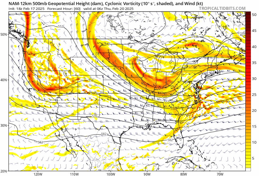
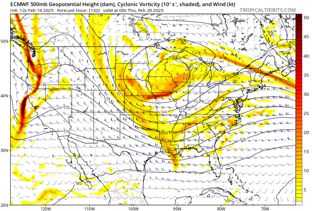
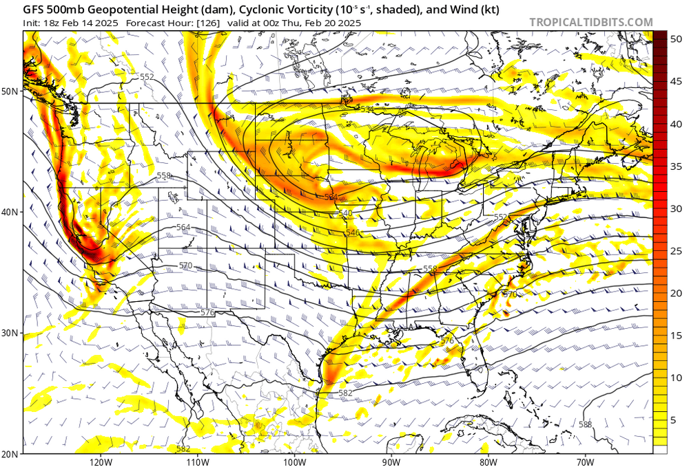
Hilarious trend on the last three GFS runs - amplified, more ridging out west, phase with the NS in decent spot. Feel like we've seen the GFS do this around the 120-180 hr range just to slowly flatten/shear the energy over time as we get closer to the event. Rinse and repeat. CMC with a very different view of things - let's see if the Euro budges at all
-
That fluffy white powder
-
God we're grasping at straws but f it - we have nothing to lose. NAM shift is being caused by the spacing from the energy on the Pac Coat being pulled back. You can see the heights building between the TPV and SW out in Wyoming giving the TPV room to stay more West and deepen a bit further. CMC had a noticeable pullback of the energy out west as well - not really noticing much of a shift on the GFS tho. Regardless - too little too late for most of us, but hope it's on to something for once.

-
Don't forget that dews are going to be near 0 to start the precipitation tomorrow - it will take time and a considerable amount of precip falling first to saturate that column. Edit: up towards the DC area
-
It’s time we put some respect on the GFS’s name for standing firm the last [emoji[emoji[emoji638][emoji639][emoji[emoji6[emoji640][emoji638]][emoji640][emoji6[emoji640][emoji637]]][emoji[emoji638][emoji639][emoji[emoji6[emoji640][emoji638]][emoji640][emoji640]][emoji[emoji6[emoji640][emoji638]][emoji640][emoji640]]]][emoji639][emoji[emoji6[emoji640][emoji638]][emoji640][emoji6[emoji640][emoji637]]][emoji[emoji638][emoji639][emoji[emoji6[emoji640][emoji638]][emoji640][emoji640]][emoji[emoji6[emoji640][emoji638]][emoji640][emoji6[emoji640][emoji637]]]]]-[emoji[emoji[emoji638][emoji639][emoji[emoji6[emoji640][emoji638]][emoji640][emoji6[emoji640][emoji637]]][emoji[emoji638][emoji639][emoji[emoji6[emoji640][emoji638]][emoji640][emoji640]][emoji[emoji6[emoji640][emoji638]][emoji640][emoji640]]]][emoji[emoji[emoji638][emoji639][emoji[emoji6[emoji640][emoji638]][emoji640][emoji6[emoji640][emoji637]]][emoji[emoji638][emoji639][emoji[emoji6[emoji640][emoji638]][emoji640][emoji640]][emoji[emoji6[emoji640][emoji638]][emoji640][emoji640]]]][emoji639][emoji[emoji6[emoji640][emoji638]][emoji640][emoji6[emoji640][emoji637]]][emoji[emoji638][emoji639][emoji[emoji6[emoji640][emoji638]][emoji640][emoji640]][emoji[emoji6[emoji640][emoji638]][emoji640][emoji6[emoji640][emoji637]]]]][emoji[emoji6[emoji640][emoji638]][emoji640][emoji6[emoji640][emoji637]]][emoji[emoji638][emoji639][emoji[emoji6[emoji640][emoji638]][emoji640][emoji6[emoji640][emoji637]]][emoji[emoji638][emoji639][emoji[emoji6[emoji640][emoji638]][emoji640][emoji640]][emoji[emoji6[emoji640][emoji638]][emoji640][emoji640]]]]] days. We discounted it but it never fully wavered from its south and OTS solutions. Our shortwave is coming onshore out west shortly. I fear if the trends continue into [emoji[emoji638][emoji639][emoji[emoji6[emoji640][emoji638]][emoji640][emoji640]][emoji[emoji6[emoji640][emoji638]][emoji640][emoji640]]]Z we can call this one what it is.
-
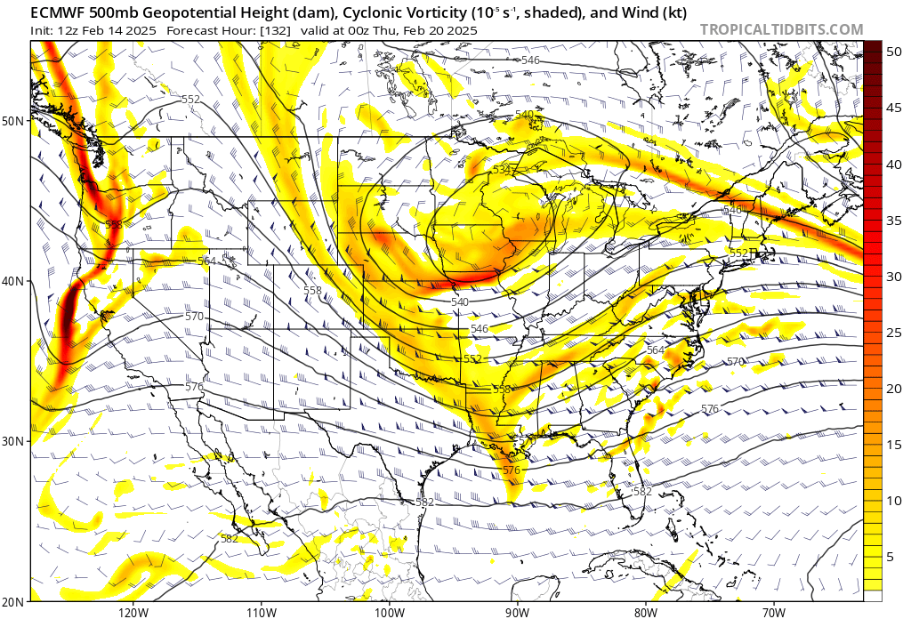
It's pretty close but that strange elongated TPV with a more north orientation than the Euro is what causes this result. Honestly a good reminder how delicate the 500mb evolution can be for the resulting surface translation. Hope its wrong lol
-
I guess you could say there's an F word for every situation in this forum
-
My excitement is muted because the GFS is on it's own with the moisture feed and boundary location. Need Euro/CMC support before the F word can safely be used for runs like that
-
Just watched an OP GFS run with four back to back to back to back storm potentials in the general area...are you not entertained?
-
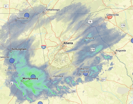
Looking at super-res reflectivity - the first thing you want to see if you are in ATL is the virga create a giant circle around the radar site (which is happening now). Next you will see that shield slowly enclose on itself as the column moistens. Likely still a few hours away from getting closer to that - the question then becomes how far north the band sets up once returns equal ground truth. Still think half an inch could be possible for inside the perimeter
-
While this is true, you can't forget that both of those seasons were Ninos and we have a much more active polar jet with the current Nina regime. There is a lot more northern stream energy flying around which can muddle the long range upper level progression. While the general idea is in place here, how far back the Western shortwave is pulled back, strength of ridging, and timing of the phase would translate to a number of different outcomes. Nothing is guaranteed - but the ceiling is high with this setup.
-
Dr. No is rolling, this should be a fun one to watch!
-
I mean.... wow. At H5 the GFS, GEM, & ICON really aren't that far apart and they have had the energy being held back further out west. The only reason the GFS is not translating into a storm for someone (or a larger storm) is because of the baja bowling ball. It shears the Western shortwave and flatens the flow. Get rid of or mute it some, and I think everyone would have a smile on their face in some capacity. Ya'll wanted to go big dog hunting? This could be it.
-
Atlanta proper made it into a heavy fronto band that came through for those 2-3 hours dropping 1-2" rates of heavy wet flakes. Reports around the city of 2-4 inches which is genuinely impressive for that short window. They're back to ZR/IP now though