

Ralph Wiggum
-
Posts
16,101 -
Joined
-
Last visited
Content Type
Profiles
Blogs
Forums
American Weather
Media Demo
Store
Gallery
Posts posted by Ralph Wiggum
-
-
RGEM is colder and remains below freezing majority of the event. Thump is non existent but signaling a major icing event with the 2nd wave interior.
-
28 minutes ago, C.A.P.E. said:
EPS isn't too enthused about the pre-Xmas potential yet. Actually looking through the members, there is a stronger signal for the period just after.
EPS has been following along late with the last few coastal storms if that matters here. Who knows which will cave?
-
 1
1
-
-
2 minutes ago, packfan98 said:
6z gefs has several members bullish for the MA.
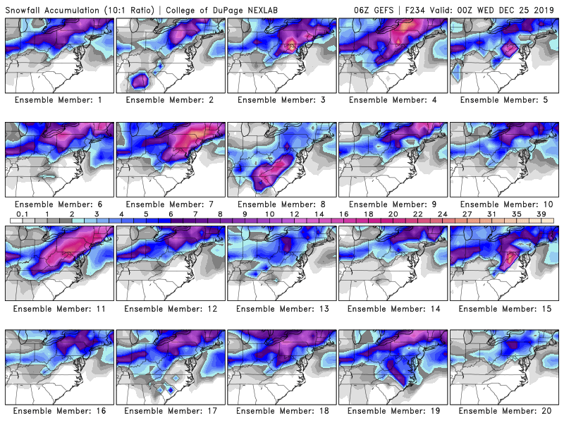
Member 3 with the 36"+ lollis ha! Some monsters in there. Cautious at this point. We've seen how much this has shifted around in only 6 hours from run-to-run.
Biggest takeaway from overnight runs...the big coastal storm idea seems more likely now. But there is going to be much fine tuning irt to track and evolution over the next few days. Plenty of small diffs at 500mb that could have huge impacts at the surface. Never liked trying to nail these down with the PV being close and trying to get involved.
-
Eagles-Cowboys game in Philly could be alot of fun with the entire season riding on it for both teams

-
It's a good look. Get this under 5 days and I think we would all be gooning. Almost there. Sure would make the Philly-Dallas / Giants-Redskins games alot of fun.
-
1
-
-
6z GFS was a step in the right direction:

-
1
-
 1
1
-
-
Mesos are coming in and colder again:

-
2
-
3
-
 3
3
-
-
0z NAM is colder....more frozen. Wind vectors have increased Northerly component at 10m with a NE/NNE trajectory thanks to a weak surface wave off the DelMarVa.

-
1
-
-
46 minutes ago, showmethesnow said:
I hate when people pee in my snow.

It could be worse, they could have peed in the snow making machine.
-
2
-
-
Unfortunately Bob is right (which is usually more often than not). There is a flat and fast flow coming up with a flood of PAC maritime air poised to invade N america and is under 10 days.
However, I am still a believer this is a relatively brief relax in the overall pattern. The effects of the PAC puke pattern will be felt just before Christmas it appears. It is what it is. So we wont have to bundle up like eskimos to visit the fam. I can deal with that....we are used to it by now right? But temps as folks noted wont be 60s and 70s but more of a muted torch with mid 40s and 50s likely being the extreme.
With that said, there is already light at the end of the tunnel(if the LR GEFS are to be believed) and by 240 hours a broad trof is already starting to develop with more of an amplified flow out West and less of a direct PAC maritime influence. Rather than post the 500mb maps (leaving that to @showmethesnow ) I am posting the 2m anomalies to simplify things for folks that are already panicking. Here is the 5-day 2m temp anomalies loop for the 18z GEFS run. 2m is difficult.to forecast but is reflective of the pattern moderation breaking down. At 240 you can see the wave of PAC air flying thru the US from W to E. However there are 2 things that stand out....first is the BN air replacing the PAC air out in w Canada and the US but also the AN temps progressing into Greenland. If the flow is to be believed, the moderation will be short-lived and warmth over Greenland generally spells ridging in that area as far as I'm concerned. Sticking to the moderation being roughly 6 or 7 days with the reload being in place by New Years. Probably wrong and tough to call but I figured why not try. If past history this early season is indicitave of length of pattern reload, it should be relatively brief.

-
1
-
-
12z mesos are quite cold on Monday morning. For some areas being inline for the biggest event of the season so far, its awfully quiet.
-
1
-
-
NAM is depicting a weak surface wave off the VA Capes after 50 hrs. Also ticked s with that. There us now a slight N of due E trajectory irt 10m wind vectors. One would think that feature will be a player as the event nears and could keep borderline areas frozen longer IF this feature on the 12k is real. Anyone else seeing a sleet/ice threat developing with this in those favored valley and inland areas?

-
12k nam is colder to start then is warmer at the surface after 54 hrs. I urge caution with that. Keep an eye on the weakness that it is depicting after 50 hrs east of the VA Capes. There is a slight N of E component to the wind vectors. That feature has also nudged south. If in fact that is real and continues to be shown it could help lock in the 2m cold more than what is being modeled. Going to be a diff of 1 degree either side for alot of folks imo.

-
This looks like it will be the 5th time we have seem some sort of snow already in my area and it is only mid Dec. Granted all have been under 1" but that has to account for something.
-
1
-
-
17 minutes ago, LVwhiteout said:
Ralph - Haven't the Nam and Euro trended slightly South also?
Yes as have the GFS and icon. As I type this the 12z nam is ticking S as well.
-
Becoming increasingly concerned regarding Monday and into the early part of Tuesday. While the global guidance may have a meh look or one that portrays us dodging a bullet, the mesos which are now beginning to get into range are seeing things differently.
Snow will over spread the region early Monday. Most guidance is trending notably colder and some mesos are developing a weak slp off the coast. This is allowing the flow to maintain more of a Northerly component. This keeps surface temps below freezing for a good part of Eastern PA thru Tuesday morning. Sleet and freezing rain could be an issue during the day on Monday all the way thru early Tueaday for parts of SE PA particularly the low lying and favored NE suburbs.
Definitely need to be watching this as guidance is starting to honk on the potential for a fair amount of frozen.
-
1 hour ago, RedSky said:
Half full of Cap'n Jack
 let's drink
cheers!!
let's drink
cheers!!
-
30 minutes ago, RedSky said:
Charlie Brown what did you get for xmas "I got a lake"
You may very well be right. Like you said 50/50. I'm just playing devil's advocate with you. Your glass is half empty mine is half full. Just keeping discussion open and both of us are presenting different sides.
-
Nobody mentioned the GEFS 5-day 2m temp avgs thru the entire run are BN aside from 1 AN panel at the start and a N panel. Really believing the moderation is going to be muted and transient. Alas, it is the GEFS but verification hasn't been shoddy lately.
-
1
-
 1
1
-
-
18 minutes ago, RedSky said:
Come on man 5" rain by tomorrow and a nasty mild last third of December better than 50/50 chance favorable it ain't
Hopefully improvement in January still too early.
Actually if you look at the GEFS 2m 5-day averages thru the run, aside from the first panel the entire run is BN with 1 N panel I saw.
-
5 minutes ago, RedSky said:
Come on man do you SEE the WEST, THAT IS NOT an east coast snow storm look, i feel like DT lol
There are always windows of opportunity in avg patterns especially as NAO blocks breakdown aka Archambault event. How many times have we had snow then behind the storm temps actually rise in lieu of ridging/moderation. January 2016 storm was a great example of that. I'm not saying this is an east coast snowstorm at all but the ens are showing some potential. To say no chance whatsoever as you are doing is silly. You did that during an accumulating snowfall in your area once or twice already in recent weeks.
-
33 minutes ago, BristowWx said:
Is there an 850 temp for that? I can’t see one on TT. Just curious
Surface temps. As you already know pretty much useless at this range irt r/s stuff but useful for showing there is cold air around and available on the GEFS.

-
 1
1
-
-
1 minute ago, RedSky said:
Show the ECM lol
Ok signal for some sort of a coastal storm at this range

-
Just now, ChescoPaWxman said:
Words of wisdom Steve....wish we had more folks on here but I truly appreciate all the peeps that do choose to post here - thanks!!
Likewise Paul


December 2019 Med/Long Range Disco
in Mid Atlantic
Posted
Looks like yesterday's Euro ... GFS never goes neg tilt. We are going to be dealing with coastal vs suppression most of the week from run to run