Ralph Wiggum
-
Posts
16,085 -
Joined
-
Last visited
Content Type
Profiles
Blogs
Forums
American Weather
Media Demo
Store
Gallery
Everything posted by Ralph Wiggum
-
I don't think any of us are banking on a single thing just yet outside of the next 4 or 5 days....at least they shouldn't be. This is still all just potential and windows of opportunity. Maybe a discrete opportunity around the 11th-12th starting to gain traction. But most of us know epic patterns don't always produce. The fact we are seeing the epic pattern evolve at least gives hope and chances.
-
Triple phase potential.
-
Pics or it didn't happen
-
Do the ens snowfall means include sleet? Always wondered this, figured now would be a good time to ask.
-

E PA/NJ/DE Winter 2024/25 Obs/Discussion
Ralph Wiggum replied to JTA66's topic in Philadelphia Region
Jan 2016 memories....similar colors even more grays and yellows with that one. -
E PA/NJ/DE Winter 2024/25 Obs/Discussion
Ralph Wiggum replied to JTA66's topic in Philadelphia Region
^^One of the individual members is pushing 40" here. I assume this could be skewing this to the high side. Or maybe not? Impressive regardless. -
E PA/NJ/DE Winter 2024/25 Obs/Discussion
Ralph Wiggum replied to JTA66's topic in Philadelphia Region
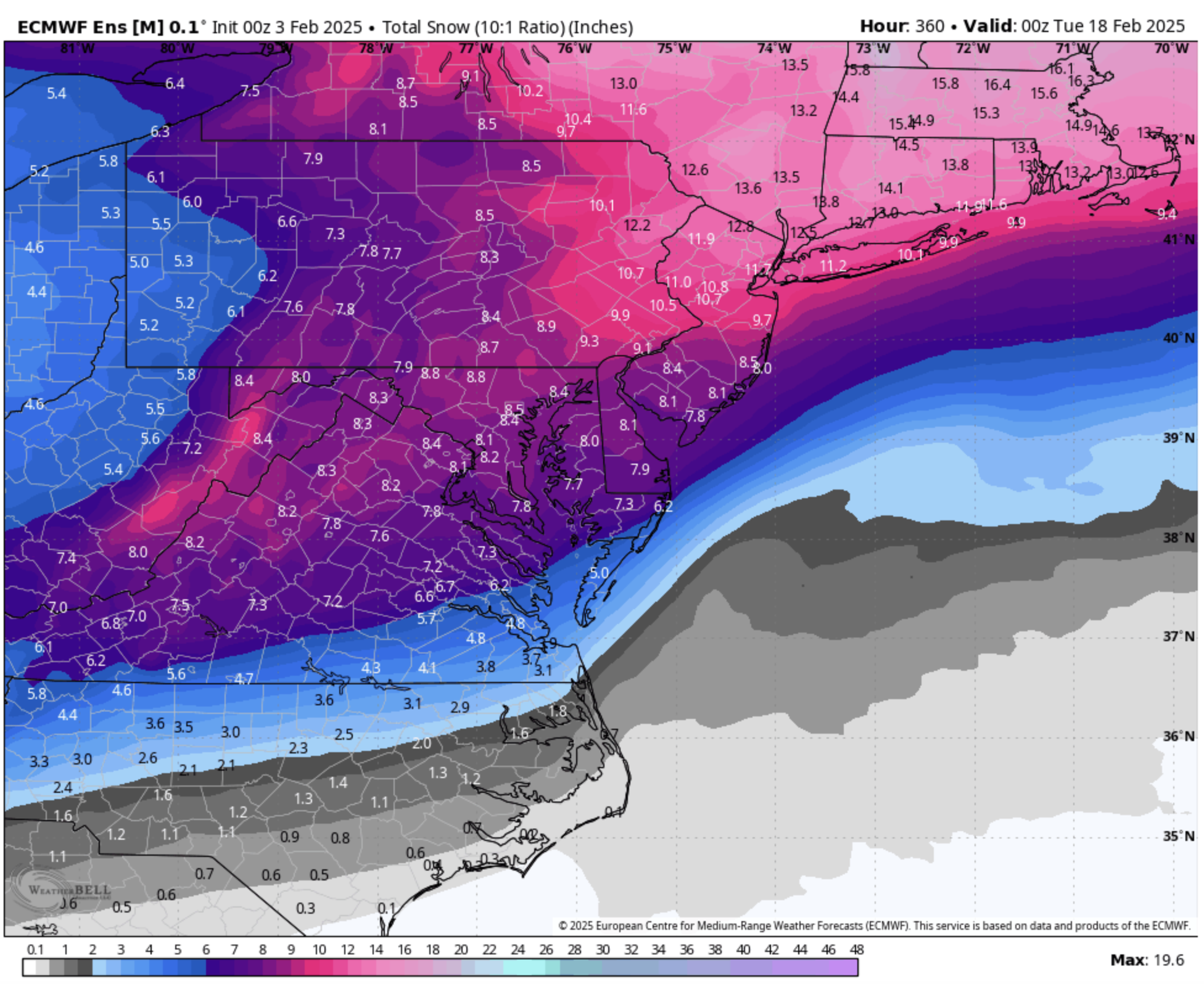
Eps snowfall mean. Borrowed from the mid atl forum. Most of this is after the 11th. Thats a crazy signal and actually increased from last two runs: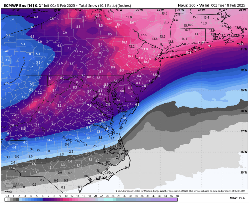
-
Ji won't be happy.
-
E PA/NJ/DE Winter 2024/25 Obs/Discussion
Ralph Wiggum replied to JTA66's topic in Philadelphia Region
We take
-
We lost the Feb 9 analfront thing on the 0z gfs.
-
Shades of 1994
-
E PA/NJ/DE Winter 2024/25 Obs/Discussion
Ralph Wiggum replied to JTA66's topic in Philadelphia Region
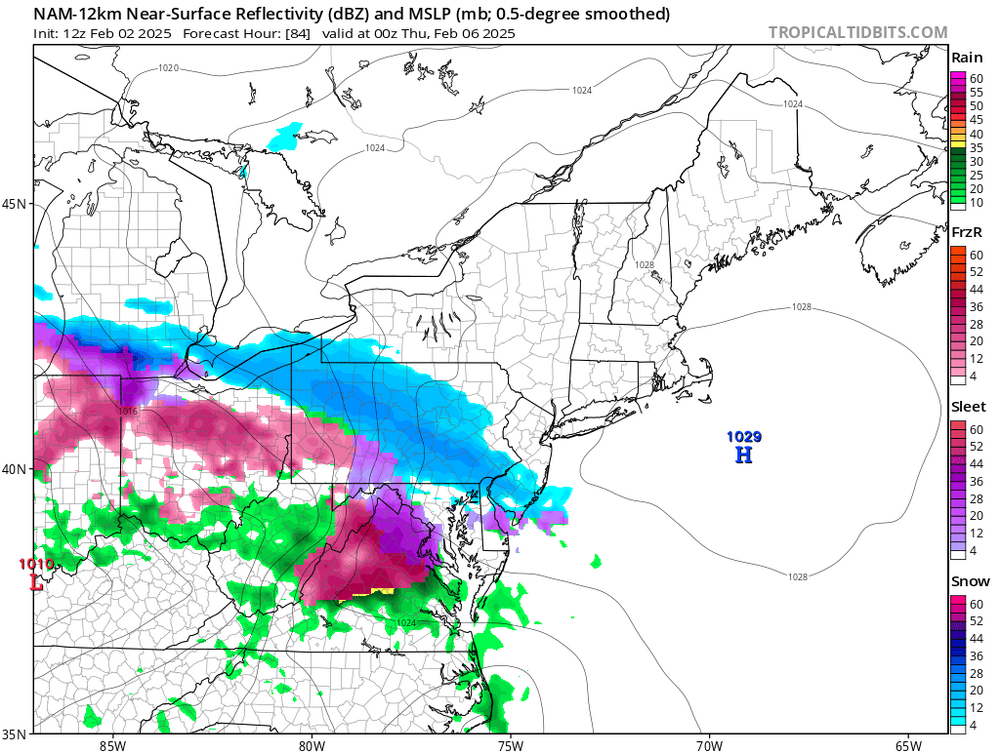
NAM'd for Wed night. Some of that is sleet but a good chunk is actually snow.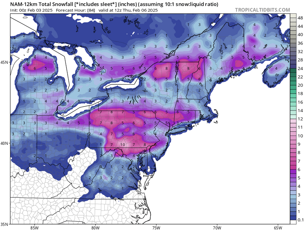
-
I do think the LR (Feb 12+) looks beyond promising. But I again sort of agree with you....how many times have we been drooling at LR ens stuff but overlooking threats in the mid range only to have the short and mid range events produce and the LR stuff fizzle? Not suggesting that, but it is funny seeing most eyes on the mid month presentation with a potential impactful event on our doorsteps.
-
Up to .3" snow here tonight fwiw. Nice 'mild' period we're in.
-
E PA/NJ/DE Winter 2024/25 Obs/Discussion
Ralph Wiggum replied to JTA66's topic in Philadelphia Region
.3" snowfall on the evening. Nice surprise overachiever. -
E PA/NJ/DE Winter 2024/25 Obs/Discussion
Ralph Wiggum replied to JTA66's topic in Philadelphia Region
Your too busy watching out for planes and the Feb 10+ threats -
Cool to see this threat continue to get colder across 'most' guidance. Guess your "no snow for the next 15 days" call is in jeopardy?
-
Wow, 2 of your last 3 posts I agree with. SPV split must be freezing hell over.
-
And the rgem went to the gfs so yeah
-
Might be the analfront thing the euro was showing.
-
E PA/NJ/DE Winter 2024/25 Obs/Discussion
Ralph Wiggum replied to JTA66's topic in Philadelphia Region
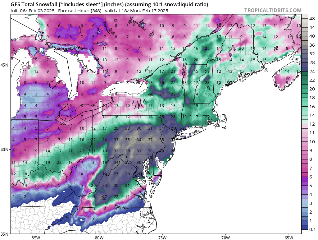
Eps is just insane. The mean snowfall maps for after the 10th thru the 17th are off the charts. Tbh havent seen such a strong snowstorm signal at this range since possibly Jan 2016. Major signal across the board. -
That's a chilly President's Day.
-
P30 for me and I'm good for 5 years.
-
E PA/NJ/DE Winter 2024/25 Obs/Discussion
Ralph Wiggum replied to JTA66's topic in Philadelphia Region
GFS has a few hits and was loading up a KU event at the end of the run. Groundhog will be right. -
E PA/NJ/DE Winter 2024/25 Obs/Discussion
Ralph Wiggum replied to JTA66's topic in Philadelphia Region
Realizing this is the NAM at range, but this looks quite wintry. And with LP developing near the outer banks, anything to keep those winds with a Northerly component will keep interior section in the CAD.