Ralph Wiggum
-
Posts
17,383 -
Joined
-
Last visited
Content Type
Profiles
Blogs
Forums
American Weather
Media Demo
Store
Gallery
Everything posted by Ralph Wiggum
-
Plenty of time for things to change as we have already seen this season, but biggest thing going against it is the ridge axis out west not being stout enough to allow for amplification in time which yields a system bombing just offshore downstream. Has an eyebrow raised tho.
-
We talked about this yesterday and now Bob C is on board as well. If we get a look like that going into mid month. All bets are off. And it is showing across the ens. This could be our literal Archambault. The nao won't last forever, its going to flip. And when it does we generally cash in. Couple this with a -ao and ridging out west, its easy to see why some of us are lighting up.
-

E PA/NJ/DE Winter 2025-26 Obs/Discussion
Ralph Wiggum replied to LVblizzard's topic in Philadelphia Region
Would be awesome. But in all honesty I think we r toast for the next 10 days minimum as the cold will be overwhelming the pattern. Maybe we can cash in on a clipper refresher. But I think when the cold starts to relax after the 4th, thats when we will score again and extending into the middle of the month. The book-end type thing with the cold pattern sandwiched in-between. -
January 25-26 Winter Storm Potential
Ralph Wiggum replied to Ralph Wiggum's topic in Philadelphia Region
CMC getting dissed. Not only was it in line with the NAM mix line, but did better with the thump. -
January 25-26 Winter Storm Potential
Ralph Wiggum replied to Ralph Wiggum's topic in Philadelphia Region
Mix of sleet and fzra here (80/20), temp holding at 14F. -
January 25-26 Winter Storm Potential
Ralph Wiggum replied to Ralph Wiggum's topic in Philadelphia Region
Seeing more reports of freezing rain now. Hopefully we can get the precip out in the next few hrs. -
January 25-26 Winter Storm Potential
Ralph Wiggum replied to Ralph Wiggum's topic in Philadelphia Region
Flakes mixing back in here. Up to a balmy 13F -
January 25-26 Winter Storm Potential
Ralph Wiggum replied to Ralph Wiggum's topic in Philadelphia Region
Going off his text, I cant confirm. -
January 25-26 Winter Storm Potential
Ralph Wiggum replied to Ralph Wiggum's topic in Philadelphia Region
My buddy in Wallingford getting freezing rain and 23 attm. He said no more pinging just raining. -
January 25-26 Winter Storm Potential
Ralph Wiggum replied to Ralph Wiggum's topic in Philadelphia Region
Interestingly enough, pouring sleet here and temp back down to 10F from 12F. -
E PA/NJ/DE Winter 2025-26 Obs/Discussion
Ralph Wiggum replied to LVblizzard's topic in Philadelphia Region
Maybe we can book-end storms. Then call it a winter. I would be ok with this and an early spring. Winter has been ok in my book. Zero complaints thus far. -
E PA/NJ/DE Winter 2025-26 Obs/Discussion
Ralph Wiggum replied to LVblizzard's topic in Philadelphia Region
Agreed and hey, at least it isnt "wasted cold"....we cashed in and this should be around for a while. -
E PA/NJ/DE Winter 2025-26 Obs/Discussion
Ralph Wiggum replied to LVblizzard's topic in Philadelphia Region
Let's do a repeat in 2 weeks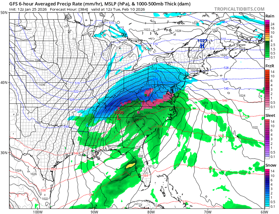
-
E PA/NJ/DE Winter 2025-26 Obs/Discussion
Ralph Wiggum replied to LVblizzard's topic in Philadelphia Region
Looks like guidance all but lost the threat for next weekend. But the GFS has a Feb 10 overunning snowstorm -
January 25-26 Winter Storm Potential
Ralph Wiggum replied to Ralph Wiggum's topic in Philadelphia Region
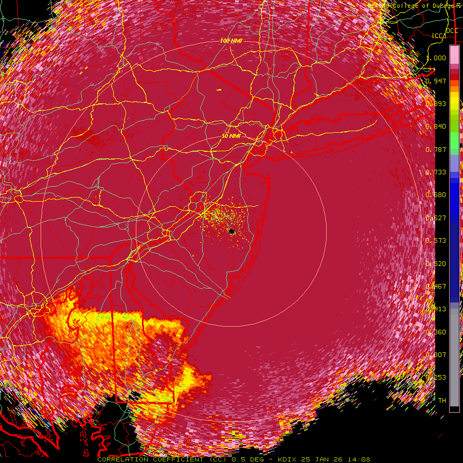
Radar looks like the line is blasting up to Scranton ffs. -
January 25-26 Winter Storm Potential
Ralph Wiggum replied to Ralph Wiggum's topic in Philadelphia Region
Timed that one nicely....just got in from snowblowing. By the time I was done, a fresh quarter to half inch of snow fell to protect the walkways then swiftly turned over to pouring sleet. Off to commence beer drinking on the championship Sunday. Will deal with the garbage in the AM. 12F, total snow 7.7" prior to sleet. -
January 25-26 Winter Storm Potential
Ralph Wiggum replied to Ralph Wiggum's topic in Philadelphia Region
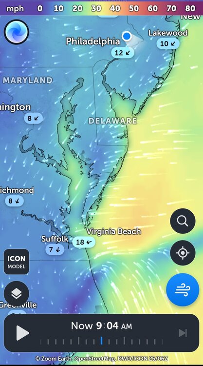
Winds almost due N now here and gusting for sure. Lots of blowing and drifting. -
January 25-26 Winter Storm Potential
Ralph Wiggum replied to Ralph Wiggum's topic in Philadelphia Region
Just shy of 6" here, 11F and puking pixie dust. -
January 25-26 Winter Storm Potential
Ralph Wiggum replied to Ralph Wiggum's topic in Philadelphia Region
NAM the first to show the warm surge (or was it actually the cmc?). In any event, nam never wavered. -
January 25-26 Winter Storm Potential
Ralph Wiggum replied to Ralph Wiggum's topic in Philadelphia Region
Just cleared the deck, now at 5.25" and piling up quickly. Still 10F. -
January 25-26 Winter Storm Potential
Ralph Wiggum replied to Ralph Wiggum's topic in Philadelphia Region
Fv3 has snow hanging on here til 4pm but then by 9PM plain rain. Feel like the plain rain line is inevitable now for SE PA. Going to be a mess in the AM when it all refreezes. Possible worst case scenario -
January 25-26 Winter Storm Potential
Ralph Wiggum replied to Ralph Wiggum's topic in Philadelphia Region
Parents in North Cape May confirming sleet -
January 25-26 Winter Storm Potential
Ralph Wiggum replied to Ralph Wiggum's topic in Philadelphia Region
About 15 min -
January 25-26 Winter Storm Potential
Ralph Wiggum replied to Ralph Wiggum's topic in Philadelphia Region
Up to 3.75" here. Mix line is on the move
-
January 25-26 Winter Storm Potential
Ralph Wiggum replied to Ralph Wiggum's topic in Philadelphia Region
Looks like the low is right on the coast of N NC. More of an easterly component here now ENE breeze with blowing fluff. 10F