.jpg.55167780a4ecb1eb92600eefed007ebf.jpg)

weatherbo
-
Posts
6,418 -
Joined
Content Type
Profiles
Blogs
Forums
American Weather
Media Demo
Store
Gallery
Everything posted by weatherbo
-
Caught the northern extent of the precip last night. A little thunder and lightning and .43" of rain. Should turn sunny and breezy today with an early high in the upper 70's before cooling. Low in the upper 40's tonight and low 40's tomorrow night. Probably some scattered 30's in the usual spots. Have only had 3 80's this year so far, an 81, 81, and 86. That's looks to continue for a bit. Can't believe it's almost July.
.thumb.png.7f891958a8b1911f13140f0befe56493.png)
-
Right at an inch of rain so far today. Temp stayed in the low 50's. Spent the afternoon reading Edgar Allen Poe's The Pit and the Pendulum... seemed fitting.
-
53 with light rain/fog and a slight upslope northeast wind. Just a damp and chilly day. Yuk!
-
64/50 currently with p/c skies and breeze from the northeast. Low tonight in the upper 40’s. Very nice first day of astronomical summer.
-

Spring/Summer '24 Banter and Complaint Thread
weatherbo replied to IWXwx's topic in Lakes/Ohio Valley
Meanwhile, in Glacier...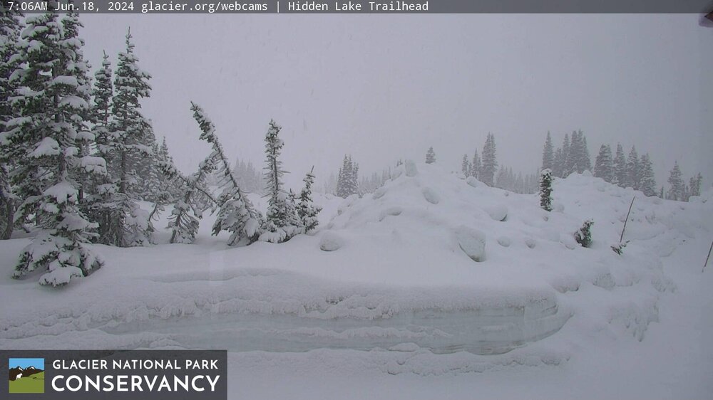
-
Very heavy rain fell over the western UP last night, 2-4 inches over in Baraga, S Houghton and Ontonagon Countines while 1.2 inches fell here at home and 1.84 down in Big Bay... my three day total is 2.28". High topped out yesterday @ 86 degrees, cooler less humid air is already beginning to filter in with 71 for a high today followed by upper 60's for the rest of the week along with some heavy rain chances as well. Lake Superior levels should see a sig rise in the next weeks from the heavy rain in the N woods.
-
79/73 definitely the most summery day of the season. And first 70 dew…Oppressive.
-
57/60 this morning after receiving 3/4's of an inch yesterday that saw a morning high of 73 then falling back into the upper 50's to near 60 after the storms passed and winds turned east. Going to be a real warm and humid day with a high of 88. Will be the warmest it's been here at my house since September 5th of last year. Having No AC, I will head down to a quiet little rocky beach in Big Bay and fight the black flies instead.
-
Severe thunderstorm watch with a nice slug of rain moving in
-
Not exactly sure how much humidity has to do with the abundance of ferns because generally this isn't a very humid environment. The fiddle ferns shown in my pic last week grow in heavily wooded areas with minimal sunlight and do generally like soil conditions a little wetter. There's a second fern that grows around here (not sure the name) that can tolerate a bit more sunlight and drier soil conditions and is even more prevalent than the fiddle fern, at least around here, and you have to be careful walking through them in the summer as I have found some pretty large bee nests nestled in them and predators can also hide well and ambush a chicken. Warm and humid today, high of 73. Decent shot at rain. Looking forward to the 87 in the forecast tomorrow. This is a pic of the second variety of ferns.
.thumb.jpg.ddf8fce3b1d3a52835d4fe65fa7c2100.jpg)
-
.3 inches between last night and today. High temp is the current temp of 63 degrees, dp is 62 so it's pretty humid out. Nice breeze tho.
-
Rain overnight was a bit of a disappointment, only managing .12". Would be nice to receive at least another .5". Still plenty of opportunity and it'll be on the warm side this week. Real heat stays south of here.
-
64 here currently with cloudy skies. Forecast started with a mostly sunny day but that's def not going to happen. Should reach near 70 today if a little more sun peaks through. NAM has around 2.5 to 3 inches of rain here through Monday afternoon, and still raining. Even tho the garden could use a little water, I'll hold off being its cool and cloudy and let mother nature do the work.
-
Lake breeze has moved inland passed my location. Full Sun and 63. Feels wonderful out working in the yard. Shade is even a hint cool. Garden is soaking in the sun. To those few in this sub that live near a Great Lake, it’s a different world.
-
Completely escapes the heat lol
-
48 for the low this morning. Should top out in the upper 60's today before some unsettled weather for the weekend. Point has the peak of the heat here @ 84 Tuesday before falling back into the 70's. June cruising by.
-
Warmed to 74 before a quick moving thunder shower with some pea sized hail moved through dropping a quick .29”. Temp has cooled to 66. clear overnight with a low around 47 expected.
-
Received nearly a half an inch of rain last night with a brief thundershower, some gusty winds too. South of here around Negaunee had some tremendous lightening and just over a half inch. It was welcome rain. Today will be a windy day with a chance of isolated storms later and a pleasant high of 72. Not sure how deep into the heat the northern lakes will get next week but mid 80's look like a good bet for a few days.
-
A much warmer morning, low of 48. Should see a nice summer day with a high around 80. Chance of showers and maybe a rumble of thunder but living in this part of the UP I've come to lower my expectations for storms. Cool lake is a killer.
-
Quite frosty this morning with 34 degrees. About a dozen other sites were 32 or below, Including Marquette Sawyer @ 32. Hopefully last of the season. Glad I covered the garden well and brought in my potted flowers. Cool spots: Stonington 28 Champion 29 Baraga Plains 29 Doe Lake 29
-
Had 37 at my house. No frost otg but there was some on the roof of my house. Tonight should be similar. cool spot was Baraga Plains with 26. currently full Sun, breezy and 58. Frost advisory issued for the entire UP.
-
Need some good garden weather.
-
Edit: 49 47 46 with light sprinkles Cloudy and 50 degrees at 1:30 with a strong northerly flow... sweatshirt weather. Still in the upper 40's just west of here in the higher terrain. Should clear this evening with upper 30's a good bet. Return to sun and low-60's for Monday then 70 by Tuesday with a string of them to follow.
.thumb.png.d19a968dd55b7e341a405ed1ad21a125.png)
-
Widespread 30's and 40's for lows last night. Cool spot was Spincich Lake at 35. Northern lights were also visible in the northern sky after midnight and before clouds arrived. Cool today in the mid 60's and even cooler tomorrow with a high around 54 forecast. As much as I do enjoy the cooler temps, I am ready for some summer like weather. Backyard is lush
.thumb.jpg.fe58861bc61d13bcbbd5409267cf20ad.jpg)
-
Spring/Summer '24 Banter and Complaint Thread
weatherbo replied to IWXwx's topic in Lakes/Ohio Valley
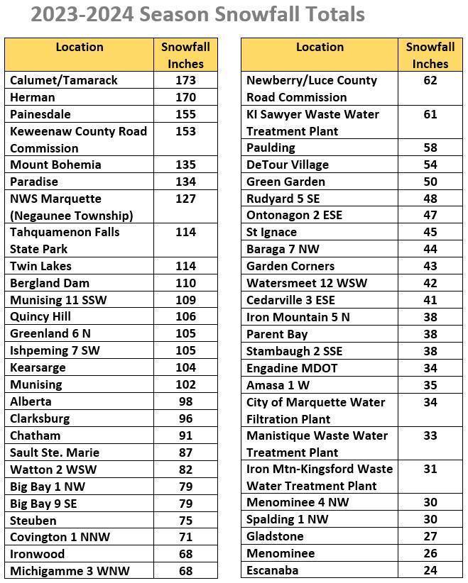
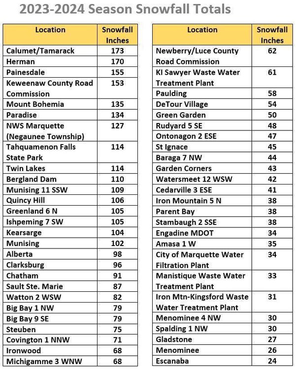
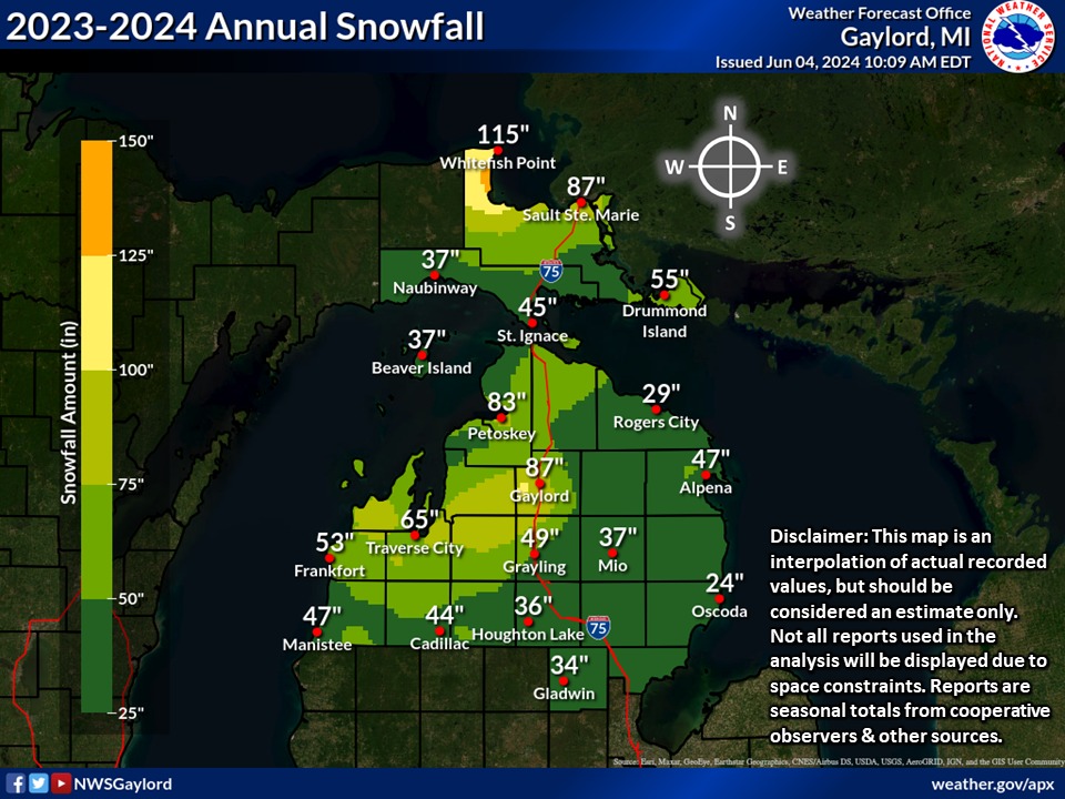
Received around 160-170 inches in my area... love where I live. Hoping for a much better season! MQT We’re a little late posting the season snowfall map for this past snow season, but really there’s not much to look at. Of the past 22 seasons for which season snowfall maps have been created at NWS Marquette, this is the first in which no location in Upper MI exceeded 200 inches for a season snowfall total. There have been 4 seasons in the last 22 that were close to failing to reach 200 inches: 2009-2010, 2010-2011, 2011-2012 and 2020-2021. What made this past snow season even worse for those who enjoy snow recreation and for the businesses that rely on snow was the frequency of warm weather that caused melting of the snow that fell. On a final note, for Upper MI, the first snowflakes of the 2023-2024 season were observed on October 7th and the last snowflakes where observed on April 23rd. You can view past snow seasons back to 2002-2003 at https://www.weather.gov/mqt/seasonsnowfallmaps N Lower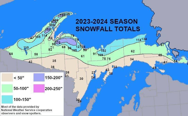
.png.8c88708fc97f5c4473d4468aeb7f0b56.png)


.jpg.f8fb8fd7f916f2f9459e18171ce36d26.jpg)
.png.40515ccde9acb601f00c71b3463403af.png)
.jpg.103fda8620f3624136ed435790e7f279.jpg)