.jpg.55167780a4ecb1eb92600eefed007ebf.jpg)

weatherbo
-
Posts
6,418 -
Joined
Content Type
Profiles
Blogs
Forums
American Weather
Media Demo
Store
Gallery
Everything posted by weatherbo
-
One good blow will chill it down quickly.
-
Second day here in the low-mid 80's... trees about 40-50% bare now. Feels very odd outside. Actually looking forward to some chilly LE rain later this week.
-
The pleasant temps and dry weather this month continues. It's been nearly 2 weeks since any decent rain at my house... hopefully that changes this weekend. Leaves falling quickly as peak has passed here.
-
Decided to pull a trail cam today located in front of the chx coop and came across this big guy looking for an easy meal. Most likely attracted to the feed more so than the chx's.
.thumb.jpg.00b57d3babea888f846671843b141d9a.jpg)
.thumb.jpg.4f57adb458dd0f843b69d37667d730cb.jpg)
.thumb.jpg.97c68f50b08038195025ab4b30d4285e.jpg)
.thumb.jpg.c112b1e750bd099d1db4e27da825184f.jpg)
-
Loving the dry weather lately. Peak is here, close to schedule. Took this yesterday.
.thumb.jpg.e0287699c0b4444fafd1a972492575e8.jpg)
-
Also looks like a good chunk of the UP will see a decent freeze tomorrow night. Most of the sub looks cool. Alek looking toasty in the city.
-
It's been downright chilly up here past couple days with highs in the 50's. Looks like a couple frosty nights are in store as well. At least it's not snowing... yet. Leaves changing quickly. I'd estimate peak to be in 2 weeks. MQT Today’s “On this Day in Weather History” post is a sign of the changing seasons. From this point forward, snowflakes could be in the air any day now. That said, there are no indications for the pattern to turn cold enough for snow in Upper Michigan anytime soon.
-
Well, I don't exactly live here for the palm trees. I enjoy a northern climate.
-
High of 51 here at midnight, sitting at 48 currently with just over .5” of lake effect rain overnight and today. In a few short weeks will likely see first flakes of the season.
-
93 here yesterday. MQT in Negaunee hit 95 breaking the all time record for September. Currently 83/73 with 88 expected for the high today. With no AC, I'm ready for the rain and cool weather this week... 52 for a high Thursday.
-
Didn't tag 90 like expected... peaked at 87. Another shot tomorrow, point has 90 again.
-
Point has 46 for tonight then a dramatic warm up which I’m looking forward to. time to wrap up Summer projects and get ready settle in for Fall. what’s the coolest you’ve been? I know you’re really close to the lake.
-
Another cool one here with 42 for the low. Point has 91 Sunday! Some other spots: Baraga Plains 30 Kenton 31 Paulding 34 Wakefield 34 Ironwood 35
-
It wasn't a big deal, it just doesn't happen widespread every year. And the point you're trying to make is silly and borderline stupid.
-
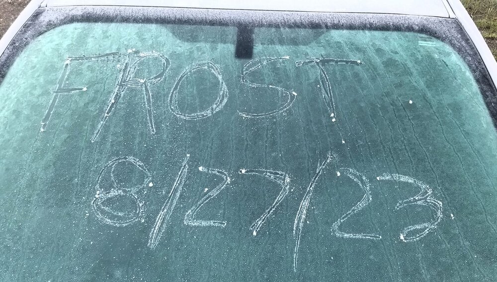
MQT's frost adv is the first of this season in the lower 48. The last frost adv issued in the lower was on June 23rd, out of the Pocatello, ID WFO. The last one issued by MQT was June 12th, so that's a 75-day respite from frosty weather. Interestingly, the only other August frost I've had since living here was Aug 28th of 2015 I believe. Low reached 38 here with a light frost on the roof. I see Ironwood made it all the way down to 30 with a heavy frost over that way. A couple other cold spots... Baraga Plains 27, Kenton 30, and Wakefield 31. Republic, Marquette County:
-
Very Autumnal like day. Breezy with a high of 56. Frost advisory for portions of the interior UP tonight, point has 38 here for the low. Will likely be some 20's in traditional cool locations.
-
A bust with the storms last night. currently 62/62 with low clouds. Temp probably won’t move much today. Heat looks wicked to the south.
-
Conditions pretty similar here. Only 59 at 1:00 pm. Had 1.3" late overnight/early this morning.
-
Not sure. I’ve wondered that myself. Drought conditions in the western UP play a role I’m sure. There’s also been some pretty cool nights there as well. In my area, there’s been plenty of rain all summer, so idk.
-
This guy drive 500 plus miles a week documenting the color change in the UP. You can follow for better area info. http://funintheup.com/fallcolors/upper-peninsula-fall-color-report.html
-
Warm and breezy yesterday, 83 for the high. Warmest the point has the next 7 days is 80 on Thursday. Don't mind at all escaping the heat wave. Comparing pics, looks as if leaves are running around 10 days ahead of last year. Peak should be in 4 weeks if this holds.
-
45 for the overnight low here. Looking at 87 for tomorrow now. If it does indeed hit 87, it will be the warmest temp since June 20th.
-
Showers with some embedded thunder moved through last night after I fell asleep. Rain gauge reads .74 this morning. A breezy, cool couple days before a warm saturday with 85 predicted. On a side note, today is the first day this season the sunlight loss has reached 3 minutes a day.
-
A coolish morning with a low of 49. Fall-like system stays south of the UP today with a fourth day of highs in the mid-60's before a warming trend tomorrow. Leaves becoming a tad bit more noticeable. Hard to believe frost can come into play in a couple weeks.
.thumb.jpg.8aea03955ac4990232ae57744803195f.jpg)
-
45 earlier this morning before clouds and showers moved in. Coolest reading I could find was 38 at Doe Lake in Alger County. A wet and cool few days in the offing. Fine by me.


.jpg.f7d80d1e6d977c1d6bbd334c42c49e68.jpg)
.jpg.3480db974540458dbecc692b28f6f9ca.jpg)
.jpg.c8f8d57d4388b77c78f69b5eca8e991b.jpg)
.jpg.800c52b80251fc133137c1e06bb0f0bc.jpg)
.jpg.db31a6c07064e0f832c4332b6c3affe0.jpg)


.jpg.78287b265f6971a3aefc24ec47aab68d.jpg)
