DeltaPilot
-
Posts
147 -
Joined
-
Last visited
About DeltaPilot

- Birthday 12/12/1960
Recent Profile Visitors
1,900 profile views


-
There were several obviously large Tornados that rolled through Eastern AL early this am. Anyone have any info on tracks and severity/ damage assessments on these? This place used to do a great job of documenting that. I see very little of that now during and after severe events here.
-
After midnight tonight Bankdawg. Probably in early am is what Im seeing. Get yourself a good radar app that shows velocities, doppler, and warnings. I pay for RadarScope pro.
-
The runways probably finally dried out enough or they treated them. My guess is it will be good to go in the am tomorrow.
-
I know I looked at a LOT of models last week, who didnt!!! But what I recall is most of the models got quite a few runs which looked very much like what we actually got. All of the models at one point or another had several ensemble runs which kind of nailed it. Im curious for you guys who look way closer at this stuff than most of us do which ones got the overall system "mostly" correct for the gulf states and into the Carolinas, I.E the southeast?
-
Suzook. 6784808918 feel free to text me I do a 2 day trip and get back Sat afternoon. Figure out when works for my winnings!
-
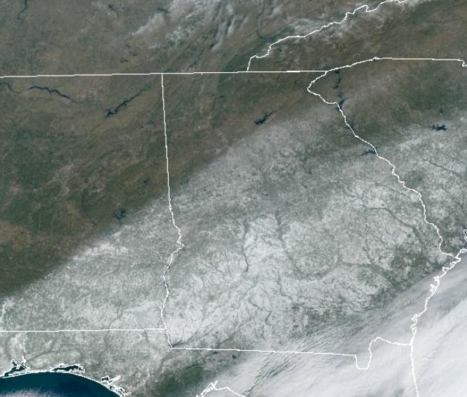
The snow line literally hugs I-85.
-
I finished up with just shy of 1.5" Im calling it 1.3" here. Pretty morning but the roads last night and into this am were and still are a shitshow. Should get melting on all sun exposed surfaces cranking up any time now and improve the situation. Im hearing the ATL airport and Delta Operations are a full on complex IROP causing massive delays and cancellations. Im sure every early go today needed de-icing and thats just fuel added to the fire. Word on the street is over 500 ground/ramp personnel either called in sick or could not make it in. Will take a few days to smooth out, but its pretty bad.
-
I just measured, 3 places, right at 1" as of about 5 minutes ago. Couple miles SE of KFFC. Snowing pretty good still here. ATM I'd call it light to occasional moderate. Im guessing we could get close to 2 here if this keeps up for another couple more hours. KFFC Metar is 1/2 M SN FZFG. Interestingly, it did not stick to the roads for quite a while.
-
Measured 1" here about 25 minutes ago in Senoia, GA. Snowing light to occasionally moderate now. Temps going back down, 25 here. Im going to guess we might get near 2" if it keeps up like this for another few hours, but Im pretty happy. Two measurable events in one month. For being "on the line" in a bunch of the models over the last three or four days, I'd say this is going to over perform here. NWS had lowered totals to T-1/2 inch 48 hours ago.
-
Solid light snow now, roof picking up a coating. 28 degrees
-
As a pilot ive seen some pretty crazy stuff with regards to snowfall and coverage. From higher altitudes its hard to fathom how the line can be extremely abrupt. Like someone painted the earth with a brush.
-
We keep getting little bouts of flurries here. Very light and usually lasts about 5-10 minutes. Happening since about 930 or so this am. Its trying, but the column is still too dry.
-
We have had flakes off and on now for about 45 minutes. Good sign.
-
Bench, I think she will be fine. Still gonna be a bit before the column gets saturated. Think things will run fine, but once it starts sticking the deice operation will begin and that will likely cause delays in the range of an hour or so, then it will get ugly into the evening later on. Right now would more depend on where her plane is coming from since there are a lot of impacts along the gulf coast states.
-
Son in LaGrange reporting light snow at surface @ 7:50am