yoda
-
Posts
60,268 -
Joined
Content Type
Profiles
Blogs
Forums
American Weather
Media Demo
Store
Gallery
Everything posted by yoda
-
Eye open on the west side per VDM
-
Hurricane Ian Tropical Cyclone Update NWS National Hurricane Center Miami FL AL092022 1000 PM EDT Tue Sep 27 2022 ...10 PM EDT HURRICANE IAN POSITION UPDATE... ...EYE OF IAN NOW MOVING OVER THE DRY TORTUGAS... The Key West International Airport recently reported a sustained wind of 52 mph (84 km/h) with a gust to 66 mph (106 km/h). An elevated WeatherFlow station at Smith Shoal Light reported a sustained wind of 61 mph (98 km/h) with a gust of 91 mph (146 km/h). SUMMARY OF 1000 PM EDT...0200 UTC...INFORMATION ---------------------------------------------- LOCATION...24.6N 82.9W ABOUT 175 MI...280 KM SSW OF PUNTA GORDA FLORIDA ABOUT 5 MI...10 KM S OF THE DRY TORTUGAS MAXIMUM SUSTAINED WINDS...120 MPH...195 KM/H PRESENT MOVEMENT...NNE OR 15 DEGREES AT 10 MPH...17 KM/H MINIMUM CENTRAL PRESSURE...947 MB...27.96 INCHES $$ Forecaster Bucci/D. Zelinsky
-
Hurricane Ian Tropical Cyclone Update NWS National Hurricane Center Miami FL AL092022 900 PM EDT Tue Sep 27 2022 ...9 PM EDT HURRICANE IAN POSITION UPDATE... ...LIFE-THREATENING STORM SURGE, CATASTROPHIC WINDS AND FLOODING EXPECTED IN THE FLORIDA PENINSULA... The Key West International Airport recently reported a sustained wind of 50 mph (80 km/h) with a gust to 63 mph (101 km/h). A private weather station near Coco Plum Beach, near Marathon, recently reported sustained winds of 38 mph (61 km/h) with a gust to 47 mph (75 km/h). SUMMARY OF 900 PM EDT...0100 UTC...INFORMATION ---------------------------------------------- LOCATION...24.5N 83.0W ABOUT 180 MI...290 KM SSW OF PUNTA GORDA FLORIDA ABOUT 15 MI...25 KM SSW OF THE DRY TORTUGAS MAXIMUM SUSTAINED WINDS...120 MPH...195 KM/H PRESENT MOVEMENT...NNE OR 15 DEGREES AT 10 MPH...17 KM/H MINIMUM CENTRAL PRESSURE...947 MB...27.96 INCHES $$ Forecaster Bucci/D. Zelinsky
-
Showers hang around through at least Tuesday per 18z GFS
-
Soundings would also suggest an isolated tornado threat as well in Saturday per 18z GFS
-
18z GFS gets rain from Ian into most of the region before sunrise on Saturday
-
2nd LF of Ian on 18z GFS is near Savanah, GA
-
Ian exiting east coast of Florida back into the Atlantic at 66
-
18z ICON is interesting lol... Saturday is pretty much a washout until evening... then a 2nd SLP develops (i think its a seperate SLP from Ian?) and brings more heavy rainfall back Sunday afternoon as the run ends
-
Hurricane Ian Discussion Number 19 NWS National Hurricane Center Miami FL AL092022 500 PM EDT Tue Sep 27 2022 The pressure on the last Air Force Hurricane Hunter aircraft fix fell to about 952 mb, indicating that Ian is restrengthening over the southeastern Gulf of Mexico. The eye of Ian remains well-defined on visible imagery, although radar data from Key West suggest that an eyewall replacement could be in the initial stages. The initial wind speed is set to 105 kt, matching a blend of earlier SFMR and flight-level wind data. The plane data also showed that the area of hurricane-force winds is growing on the east side of the cyclone. Ian is moving east-of-due-north, or 010/9-kt, with occasional wobbles to the north-northeast. A track toward the north-northeast is expected for the next couple of days while it moves between a ridge over the Bahamas and a trough over the western Gulf of Mexico. There has been some model convergence this afternoon showing Ian remaining stronger and vertically deeper through landfall. This solution results in a faster track, again adjusted to the southeast, and the new forecast is moved in that direction. This new NHC track is close to the corrected model consensus and between the quicker ECMWF and slower GFS models. It should be emphasized that this track remains uncertain, with a typical spread in the steering features leading to big speed and track differences down the line, not to mention the oblique angle of approach to Florida. In a few days, more of the guidance is showing Ian interacting with a shortwave trough over the southeastern United States, causing the system to move back over the northwestern Atlantic in the longer range, before turning northwestward back over land. The day 3-5 track forecast is also shifted eastward, although significant re-strengthening is not expected at long range. The outflow pattern of the hurricane is beginning to be impinged upon in the southwestern quadrant, a sign that upper-level southwesterly flow is starting to affect the outer circulation. While the shear should increase up through landfall, it is just too close-to-call whether it starts to weaken Ian or not, or whether the larger system is able to resist the shear. Additionally, an eyewall replacement cycle could be in its initial phases, although predicting these structural changes is extremely difficult. The new forecast is near the last one, a little higher than the consensus. I should note that whether Ian comes ashore as category 4 hurricane or a large category 3 after an eyewall cycle, avoiding a large and destructive hurricane for Florida seems very unlikely, and residents should heed the advice of local emergency management officials. The new forecast necessitates a Hurricane Warning for portions of extreme southwestern Florida, and a Tropical Storm Warning for the rest of southeastern Florida that wasn't previously under a warning. Users are reminded to not focus on the exact track as some additional adjustments to the track are possible. Significant wind, storm surge, and rainfall hazards will extend far from the center. Key Messages: 1. Life-threatening storm surge is increasingly likely along the Florida west coast where a storm surge warning is in effect, with the highest risk from Naples to the Sarasota region. Residents in these areas should listen to advice given by local officials and follow any evacuation orders for your area. 2. Hurricane-force winds are expected in the hurricane warning area in southwest and west-central Florida beginning Wednesday morning with tropical storm conditions expected overnight. Devastating wind damage is expected near the core of Ian. Residents should rush all preparations to completion. 3. Heavy rainfall will affect most of the Florida Peninsula for the next several days, spreading to the rest of the Southeast U.S. by Thursday and Friday, likely causing flash, urban, and small stream flooding. Considerable flooding is expected with widespread, prolonged moderate to major river flooding expected across central Florida. FORECAST POSITIONS AND MAX WINDS INIT 27/2100Z 24.0N 83.2W 105 KT 120 MPH 12H 28/0600Z 25.3N 82.9W 115 KT 130 MPH 24H 28/1800Z 26.6N 82.5W 115 KT 130 MPH 36H 29/0600Z 27.6N 82.0W 70 KT 80 MPH...INLAND 48H 29/1800Z 28.5N 81.5W 55 KT 65 MPH...INLAND 60H 30/0600Z 29.4N 81.2W 45 KT 50 MPH...INLAND 72H 30/1800Z 31.0N 81.1W 45 KT 50 MPH...OVER WATER 96H 01/1800Z 34.5N 82.0W 25 KT 30 MPH...POST-TROP/EXTRATROP 120H 02/1800Z...DISSIPATED
-
BULLETIN Hurricane Ian Advisory Number 19 NWS National Hurricane Center Miami FL AL092022 500 PM EDT Tue Sep 27 2022 ...HURRICANE WARNING EXTENDED SOUTHWARD IN SOUTHWESTERN FLORIDA... ...LIFE-THREATENING STORM SURGE, CATASTROPHIC WINDS AND FLOODING EXPECTED WITH IAN IN THE FLORIDA PENINSULA... SUMMARY OF 500 PM EDT...2100 UTC...INFORMATION ---------------------------------------------- LOCATION...24.0N 83.2W ABOUT 230 MI...375 KM S OF SARASOTA FLORIDA ABOUT 50 MI...85 KM SSW OF THE DRY TORTUGAS MAXIMUM SUSTAINED WINDS...120 MPH...195 KM/H PRESENT MOVEMENT...N OR 10 DEGREES AT 10 MPH...17 KM/H MINIMUM CENTRAL PRESSURE...952 MB...28.12 INCHES WATCHES AND WARNINGS -------------------- CHANGES WITH THIS ADVISORY: A Hurricane Warning has been extended southward on the west coast of Florida to Chokoloskee. The government of Cuba has downgraded the Hurricane Warning to a Tropical Storm Warning for the provinces of Isla de Juventud, Pinar del Rio, and Artemisa. The Tropical Storm Watch from the Suwannee River to Indian Pass, for the Upper Florida Keys, Florida Bay, and for southeastern Florida from south of Boca Raton has been upgraded to a Tropical Storm Warning. The Storm Surge Watch from Marineland to the Flagler/Volusia County Line has been upgraded to a Storm Surge Warning. The Storm Surge Watch from the Aucilla River to the Suwannee River has been discontinued. A Hurricane Warning is in effect for... * Chokoloskee to Anclote River, including Tampa Bay * Dry Tortugas A Storm Surge Warning is in effect for... * Suwannee River southward to Flamingo * Tampa Bay * Dry Tortugas * Flagler/Volusia Line to the mouth of the St. Mary's River * St. Johns River A Tropical Storm Warning is in effect for... * Cuban provinces of La Habana, Mayabeque, and Matanzas * Suwannee River to the Anclote River * All of the Florida Keys * Flamingo to Altamaha Sound * Flamingo to Chokoloskee * Lake Okeechobee * Florida Bay A Storm Surge Watch is in effect for... * Florida Keys from the Card Sound Bridge westward to Key West * Florida Bay * Mouth of St. Mary's River to South Santee River * South of Marineland to the Volusia/Flagler county line A Tropical Storm Watch is in effect for... * North of Altamaha Sound to South Santee River
-
Still 952mb/120mph at 5pm
-
LWX AFD from this afternoon .LONG TERM /FRIDAY THROUGH MONDAY/... Dry and cooler than average once again on Friday as strong high pressure remains entrenched over the northeastern CONUS. Highs for most will remain in the 60s. Rain chances start to encroach on our region as early as Friday evening as the remnants of what is now Hurricane Ian approach from the south. For the weekend and even into Monday, a great deal of uncertainty remain regarding the track of Hurricane Ian. What does seem certain at this point is that our region should at least see some rainfall from Ian Saturday into Sunday. Whether that is a beneficial or hazardous amount has yet to be seen. We will continue to monitor the forecast for Ian and adjust the forecast as needed. For updates on Hurricane Ian, visit the National Hurricane Center website at hurricanes.gov.
-
-
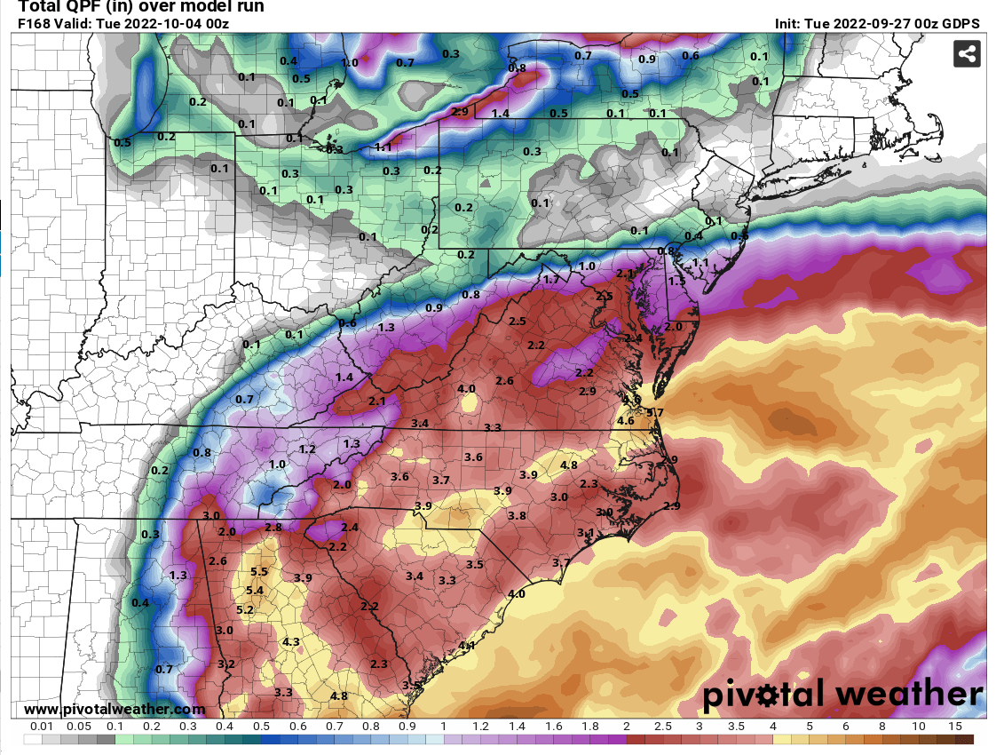
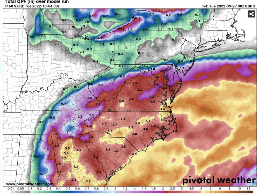
1-3" across the LWX CWA per the 00z UKIE
-
-
00z GFS says rainy Monday for all but some rain Sunday south of the i66 corridor... 00z CMC rainy late Sat into Monday morning
-
Thats why I said FWIW
-
So did the 00z GFS... so...
-
FWIW, 00z CMC slows down, but remains offshore of the west coast of FL as it goes by, makes landfall in the Big Bend of FL
-
lol look at the 00z GFS at 126... decent CAD... 1034mb HP in Quebec...
-
Thats a long time Ian is hanging around Tampa with little movement on the 00z GFS... 30 hours
-
if you choose to accept the 00z ICON, that would be a rainy weekend with maybe a threat for a few isolated tornadoes
-
lol 00z ICON goes for a 2nd landfall at Savannah, GA at 102
-
day 5 NHC has Ian (as a TD) in S NC