yoda
-
Posts
60,268 -
Joined
Content Type
Profiles
Blogs
Forums
American Weather
Media Demo
Store
Gallery
Everything posted by yoda
-
-
Day 10 Euro looks interesting...
-
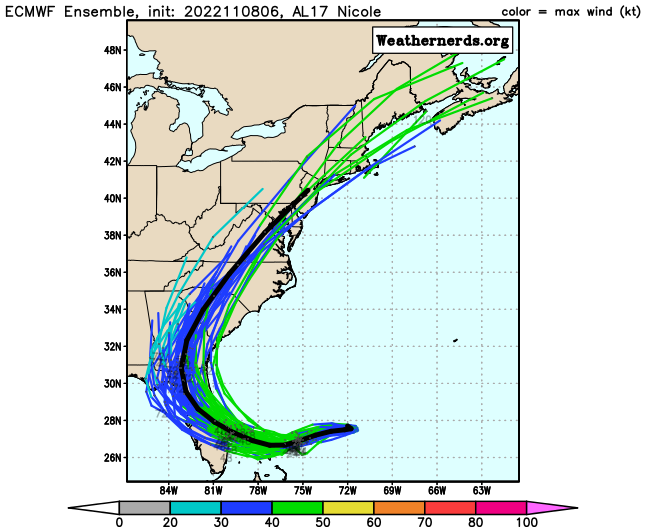
5am nhc path has Nicole just to the east of DCA at 1am Saturday
-
Guess I will be buying some Powerball tickets lol
-
Fox5 DC winter outlook https://www.fox5dc.com/weather/winter-outlook-2022-2023-snow-blizzard-dmv-dc-maryland-virginia
-
FOX5 DC winter outlook https://www.fox5dc.com/weather/winter-outlook-2022-2023-snow-blizzard-dmv-dc-maryland-virginia
-
Hurricane Lisa Tropical Cyclone Update NWS National Hurricane Center Miami FL AL152022 420 PM CDT Wed Nov 02 2022 ...LISA MAKES LANDFALL IN BELIZE... Satellite imagery and radar data indicate that Lisa has made landfall along the coast of Belize, near the mouth of the Sibun River, about 10 miles southwest of Belize City around 420 PM CDT (2120 UTC). The maximum sustained winds are estimated to be 85 mph (140 km/h), and the minimum central pressure is estimated to be 990 mb (29.24 inches). SUMMARY OF 420 PM CDT...2120 UTC...INFORMATION --------------------------------------------------- LOCATION...17.4N 88.3W ABOUT 10 MI...15 KM SW OF BELIZE CITY MAXIMUM SUSTAINED WINDS...85 MPH...140 KM/H PRESENT MOVEMENT...W OR 280 DEGREES AT 12 MPH...19 KM/H MINIMUM CENTRAL PRESSURE...990 MB...29.24 INCHES $$ Forecaster Bucci/Brown
-
Explore lololololol
-
Tropical Storm Lisa Discussion Number 8 NWS National Hurricane Center Miami FL AL152022 1100 AM EDT Tue Nov 01 2022 An Air Force Reserve Hurricane Hunter aircraft has provided critical data with Lisa this morning, showing that the storm has started to intensify. Flight-level winds have increased to 55 kt, with SFMR winds of 50-55 kt, and surface-reduced dropsonde data of about 50 kt. Thus, the initial wind speed is set to 50 kt as a blend of these data, above the latest satellite classifications. Further intensification is likely with Lisa now having a small radius-of-maximum winds in light vertical wind shear, along with the deep warm waters of the northwestern Caribbean providing ample fuel. The NHC intensity forecast calls for steady strengthening and shows Lisa becoming a hurricane in less than a day when it is near the Bay Islands of Honduras, and Lisa should intensify as it approaches Belize. For now, rapid intensification is not forecast, but since the percentage chances of this occurrence from SHIPS are increasing, this possibility must be mentioned and the new forecast is higher than the bulk of the guidance. After landfall, rapid weakening is expected and Lisa is forecast to degenerate to a post-tropical remnant low by 72 hours and dissipate shortly thereafter. Lisa continues moving just north of due west or 280/12 kt. No significant changes were made to the track forecast. A strong low- to mid-level ridge located to the north of Lisa should keep the tropical cyclone on a generally westward track during the next couple of days. This motion is expected to bring the core of the cyclone near the Bay Islands of Honduras by early Wednesday, and across the coast of Belize by late Wednesday. The dynamical models remain in relatively good agreement, and the NHC track is near the middle of the guidance envelope. Key Messages: 1. Hurricane conditions are expected in the Bay Islands of Honduras early Wednesday and possible along the coast of Belize by Wednesday afternoon. Hurricane conditions are possible in eastern Yucatan in the Hurricane Watch area Wednesday afternoon. 2. There is potential for a life-threatening storm surge near where the center of Lisa crosses the coast of Belize and for the southern portions of the Yucatan Peninsula. 3. Tropical storm conditions are expected along portions of the north coast of Honduras and Guatemala beginning tonight into Wednesday, and over the eastern Yucatan Peninsula in the Tropical Storm Warning areas beginning Wednesday afternoon. 4. Localized flash flooding is expected across portions of Belize, the Bay Islands of Honduras, northern Guatemala and the southeast portion of the Mexican state of Chiapas starting tonight through Thursday. FORECAST POSITIONS AND MAX WINDS INIT 01/1500Z 16.3N 81.8W 50 KT 60 MPH 12H 02/0000Z 16.6N 83.7W 60 KT 70 MPH 24H 02/1200Z 16.8N 86.0W 70 KT 80 MPH 36H 03/0000Z 17.0N 88.0W 80 KT 90 MPH 48H 03/1200Z 17.0N 89.4W 45 KT 50 MPH...INLAND 60H 04/0000Z 17.0N 90.9W 30 KT 35 MPH...INLAND 72H 04/1200Z 17.5N 92.5W 20 KT 25 MPH...POST-TROP/REMNT LOW 96H 05/1200Z...DISSIPATED $$ Forecaster Blake
-
Tropical Storm Lisa Advisory Number 8 NWS National Hurricane Center Miami FL AL152022 1100 AM EDT Tue Nov 01 2022 ...HURRICANE WARNING ISSUED FOR STRENGTHENING LISA... SUMMARY OF 1100 AM EDT...1500 UTC...INFORMATION ----------------------------------------------- LOCATION...16.3N 81.8W ABOUT 320 MI...510 KM E OF ISLA ROATAN HONDURAS ABOUT 430 MI...695 KM E OF BELIZE CITY MAXIMUM SUSTAINED WINDS...60 MPH...95 KM/H PRESENT MOVEMENT...W OR 280 DEGREES AT 14 MPH...22 KM/H MINIMUM CENTRAL PRESSURE...1001 MB...29.56 INCHES WATCHES AND WARNINGS -------------------- CHANGES WITH THIS ADVISORY: The government of Honduras has issued a Hurricane Warning for the Bay Islands. The government of Guatemala has changed the Tropical Storm Watch to a Tropical Storm Warning for the entire Caribbean coast. The government of Mexico has issued a Hurricane Watch from Chetumal to Puerto Costa Maya, and a Tropical Storm Warning from Chetumal to Punta Herrero. SUMMARY OF WATCHES AND WARNINGS IN EFFECT: A Hurricane Warning is in effect for... * Bay Islands A Hurricane Watch is in effect for... * North of Puerto Barrios to Puerto Costa Maya A Tropical Storm Warning is in effect for... * Entire north coast of Honduras * North coast of Guatemala * Chetumal to Punta Herrero
-
Tropical Storm Martin Discussion Number 1 NWS National Hurricane Center Miami FL AL162022 1100 AM AST Tue Nov 01 2022 The occluded low over the central North Atlantic has developed deep convection over its center, while the frontal boundaries have become displaced a long distance to its east and north. At the same time, FSU Cyclone Phase Space analyses suggest that the system has developed a non-frontal warm core. Given these changes, the system has evolved into a tropical cyclone. The ASCAT scatterometer just observed the system and indicated that the intensity is currently at 45 kt with a large area of 35 kt-plus winds. Thus the system is now a tropical storm and given the name Martin. The system is moving toward the east-northeast around 8 kt, as it is embedded in the mid-latitude westerlies in a split in the jet stream with faster westerlies both poleward and equatorward of the system. Martin should turn toward the northeast at an increasingly rapid forward speed during the next two days. The official track forecast is based upon the consensus (TVCN and HCCA) of the tightly clustered global and hurricane dynamical models. In about three days, Martin should decelerate as it merges with a developing extratropical low to its north. For the intensity, even though the SSTs are a lukewarm 25C, the upper-level temperatures are quite cold given that Martin is embedded within a deep and vertically stacked cyclone. This vertical temperature structure should enable deep convection to continue, even while the mid-level moisture is only marginally ample. The vertical shear is 20-25 kt out of the southwest, but the effects of this moderate shear are tempered by Martin moving in the same direction as the shear vector. Bottom line is that despite the month being November, Martin is expected to develop into a hurricane at high latitudes. The official intensity prediction steadily strengthens the system through 48 hr, which matches a consensus of the statistical, global, and hurricane dynamical models. Around 48 hr, Martin should transition into a powerful extratropical low as a cold front reaches near the center of the system. In about three days, post-tropical Martin should be merging with an developing extratropical system to its north but still be containing hurricane-force winds. FORECAST POSITIONS AND MAX WINDS INIT 01/1500Z 35.3N 55.9W 45 KT 50 MPH 12H 02/0000Z 35.4N 53.9W 50 KT 60 MPH 24H 02/1200Z 36.1N 50.7W 60 KT 70 MPH 36H 03/0000Z 38.7N 46.4W 70 KT 80 MPH 48H 03/1200Z 43.8N 40.0W 75 KT 85 MPH...POST-TROP/EXTRATROP 60H 04/0000Z 51.5N 34.6W 75 KT 85 MPH...POST-TROP/EXTRATROP 72H 04/1200Z 56.0N 34.9W 70 KT 80 MPH...POST-TROP/EXTRATROP 96H 05/1200Z...DISSIPATED $$ Forecaster Landsea
-
Tropical Storm Martin Advisory Number 1 NWS National Hurricane Center Miami FL AL162022 1100 AM AST Tue Nov 01 2022 ...MARTIN FORMS OVER THE CENTRAL NORTH ATLANTIC... SUMMARY OF 1100 AM AST...1500 UTC...INFORMATION ----------------------------------------------- LOCATION...35.3N 55.9W ABOUT 550 MI...885 KM ENE OF BERMUDA MAXIMUM SUSTAINED WINDS...50 MPH...85 KM/H PRESENT MOVEMENT...E OR 90 DEGREES AT 12 MPH...19 KM/H MINIMUM CENTRAL PRESSURE...997 MB...29.44 INCHES WATCHES AND WARNINGS -------------------- There are no coastal watches or warnings in effect. DISCUSSION AND OUTLOOK ---------------------- At 1100 AM AST (1500 UTC), the center of Tropical Storm Martin was located near latitude 35.3 North, longitude 55.9 West. Martin is moving toward the east near 12 mph (19 km/h). The tropical storm is anticipated to turn toward the northeast at a faster rate of forward speed during the next two days. Maximum sustained winds are near 50 mph (85 km/h) with higher gusts. Some strengthening is forecast during the next 48 hours, and Martin is expected to become a hurricane by Wednesday night before transitioning to a powerful extratropical system on Thursday. Tropical-storm-force winds extend outward up to 205 miles (335 km) from the center. The estimated minimum central pressure is 997 mb (29.44 inches). HAZARDS AFFECTING LAND ---------------------- None NEXT ADVISORY ------------- Next complete advisory at 500 PM AST. $$ Forecaster Landsea
-
TS Martin is here for about 48 hours
-
Yeah an orange or pinkish hue to it
-
Weird looking sky though
-
Wizards win tonight over the Pacers, 114-107. Think this team will make the playoffs if they are healthy enough... but probably as no better than a 6 seed
-
Nah... I like @Bob Chill better lol
-
But Ji said... oh
-
Special Weather Statement National Weather Service Baltimore MD/Washington DC 310 PM EDT Tue Oct 18 2022 MDZ001-WVZ501-190300- Garrett-Western Grant- Including the cities of Mountain Lake Park, Oakland, Grantsville, Bayard, and Mount Storm 310 PM EDT Tue Oct 18 2022 ...First Accumulating Snow for Allegheny Mountains... Snow showers are expected for locations along and west of the Allegheny Front in Garrett and western Grant Counties. Temperatures will fall below freezing, causing snow to accumulate on most surfaces. Snowfall will accumulate around 1 to 3 inches along the western slopes, with the highest accumulations expected above 2500 feet. The most widespread widespread snow showers will be late tonight through midday Wednesday, and accumulating snow may impact the Wednesday morning commute. $$ BJL/CPB
-
Freeze warning for Richmond tonight
-
Hurricane Hazel