yoda
-
Posts
61,397 -
Joined
Content Type
Profiles
Blogs
Forums
American Weather
Media Demo
Store
Gallery
Everything posted by yoda
-
DC metro 6" by 36 (00z Wed) on 12z NAM
-
Mod to heavy snow for most at 21z Tuesday (33 hours)
-
Mod to heavy snow DCA to EZF... light to moderate north of DC metro into MD at 18z Tues (hr 30) on 12z NAM
-
12z NAM looks fine through 24 IMO... snow in DC metro by 15z
-
This is what I'm thinking of now every time someone says we need to will the storm north some
-
Probably another 4 to 6 hours to go across the region I would guess
-
-
Sleet line is down in Richmond at 51 on 18z NAM FWIW
-
URGENT - WINTER WEATHER MESSAGE National Weather Service Baltimore MD/Washington DC 309 PM EST Sun Feb 9 2025 DCZ001-MDZ008-011-013-014-016>018-503>506-508-VAZ053>055-057-501-502- 505-506-526-527-100415- /O.NEW.KLWX.WS.A.0007.250211T1800Z-250212T1200Z/ District of Columbia-Cecil-Southern Baltimore-Prince Georges-Anne Arundel-Charles-St. Marys-Calvert-Northwest Montgomery-Central and Southeast Montgomery-Northwest Howard-Central and Southeast Howard-Southeast Harford-Fairfax-Arlington/Falls Church/Alexandria-Stafford-King George-Northern Fauquier-Southern Fauquier-Western Loudoun-Eastern Loudoun-Northwest Prince William- Central and Southeast Prince William/Manassas/Manassas Park- 309 PM EST Sun Feb 9 2025 ...WINTER STORM WATCH IN EFFECT FROM TUESDAY AFTERNOON THROUGH WEDNESDAY MORNING... * WHAT...Heavy snow possible. Total snow accumulations between 4 and 6 inches, with locally higher amounts possible. * WHERE...Portions of DC, central, northeast, northern, and southern Maryland, and central and northern Virginia. * WHEN...From Tuesday afternoon through Wednesday morning. * IMPACTS...Plan on slippery road conditions. The hazardous conditions could impact the Tuesday evening and Wednesday morning commutes. * ADDITIONAL DETAILS...Precipitation begins as light snow Tuesday afternoon. A steady snow follows Tuesday evening into Tuesday night, and the snow could be heavy at times. Additional wintry precipitation could continue into Wednesday morning. PRECAUTIONARY/PREPAREDNESS ACTIONS... Monitor the latest forecasts for updates on this situation. Persons should delay all travel if possible. If travel is absolutely necessary, drive with extreme caution and be prepared for sudden changes in visibility. Leave plenty of room between you and the motorist ahead of you, and allow extra time to reach your destination. Avoid sudden braking or acceleration, and be especially cautious on hills or when making turns. Make sure your car is winterized and in good working order.
-
URGENT - WINTER WEATHER MESSAGE National Weather Service Baltimore MD/Washington DC 309 PM EST Sun Feb 9 2025 VAZ025-026-503-504-507-508-WVZ501-502-505-506-100415- /O.NEW.KLWX.WS.A.0007.250211T1500Z-250212T1200Z/ Augusta-Rockingham-Western Highland-Eastern Highland-Northern Virginia Blue Ridge-Central Virginia Blue Ridge-Western Grant- Eastern Grant-Western Pendleton-Eastern Pendleton- 309 PM EST Sun Feb 9 2025 ...WINTER STORM WATCH IN EFFECT FROM TUESDAY MORNING THROUGH WEDNESDAY MORNING... * WHAT...Heavy mixed precipitation possible. Total snow accumulations between 4 and 6 inches, with locally higher amounts possible. Ice accumulations between two to three tenths of an inch possible. * WHERE...Portions of central, northwest, and western Virginia and eastern West Virginia. * WHEN...From Tuesday morning through Wednesday morning. * IMPACTS...Travel could be very difficult. The hazardous conditions could impact the Tuesday evening and Wednesday morning commutes. * ADDITIONAL DETAILS...Precipitation begins as light snow Tuesday morning. A steady snow follows Tuesday afternoon into Tuesday evening, and the snow could be heavy at times. Precipitation transitions to a wintry mix of snow and freezing rain Tuesday night. Additional wintry precipitation could continue into Wednesday morning.
-
URGENT - WINTER WEATHER MESSAGE National Weather Service Baltimore MD/Washington DC 309 PM EST Sun Feb 9 2025 VAZ036>040-050-051-056-100415- /O.NEW.KLWX.WS.A.0007.250211T1500Z-250212T1200Z/ Nelson-Albemarle-Greene-Madison-Rappahannock-Orange-Culpeper- Spotsylvania- 309 PM EST Sun Feb 9 2025 ...WINTER STORM WATCH IN EFFECT FROM TUESDAY MORNING THROUGH WEDNESDAY MORNING... * WHAT...Heavy mixed precipitation possible. Total snow accumulations between 4 and 6 inches, with locally higher amounts possible. Ice accumulations up to one tenth of an inch possible. * WHERE...Portions of central, northern, and northwest Virginia. * WHEN...From Tuesday morning through Wednesday morning. * IMPACTS...Plan on slippery road conditions. The hazardous conditions could impact the Tuesday evening and Wednesday morning commutes. * ADDITIONAL DETAILS...Precipitation begins as light snow Tuesday morning. A steady snow follows Tuesday afternoon into Tuesday evening, and the snow could be heavy at times. Some freezing rain begins to mix with the snow Tuesday night. Additional wintry precipitation could continue into Wednesday morning. PRECAUTIONARY/PREPAREDNESS ACTIONS... Monitor the latest forecasts for updates on this situation. Persons should delay all travel if possible. If travel is absolutely necessary, drive with extreme caution and be prepared for sudden changes in visibility. Leave plenty of room between you and the motorist ahead of you, and allow extra time to reach your destination. Avoid sudden braking or acceleration, and be especially cautious on hills or when making turns. Make sure your car is winterized and in good working order.
-
URGENT - WINTER WEATHER MESSAGE National Weather Service Baltimore MD/Washington DC 309 PM EST Sun Feb 9 2025 VAZ027>031-WVZ050-052-053-055-100415- /O.NEW.KLWX.WS.A.0007.250211T1800Z-250212T1200Z/ Shenandoah-Frederick VA-Page-Warren-Clarke-Hampshire-Berkeley- Jefferson-Hardy- 309 PM EST Sun Feb 9 2025 ...WINTER STORM WATCH IN EFFECT FROM TUESDAY AFTERNOON THROUGH WEDNESDAY MORNING... * WHAT...Heavy mixed precipitation possible. Total snow accumulations between 4 and 6 inches, with locally higher amounts possible. Ice accumulations around a light glaze possible. * WHERE...Portions of northwest Virginia and eastern and panhandle West Virginia. * WHEN...From Tuesday afternoon through Wednesday morning. * IMPACTS...Plan on slippery road conditions. The hazardous conditions could impact the Tuesday evening and Wednesday morning commutes. * ADDITIONAL DETAILS...Precipitation begins as light snow Tuesday afternoon. A steady snow follows Tuesday evening into Tuesday night, and the snow could be heavy at times. Some freezing rain begins to mix with the snow late Tuesday night. Additional wintry precipitation could continue into Wednesday morning. PRECAUTIONARY/PREPAREDNESS ACTIONS... Monitor the latest forecasts for updates on this situation. Persons should delay all travel if possible. If travel is absolutely necessary, drive with extreme caution and be prepared for sudden changes in visibility. Leave plenty of room between you and the motorist ahead of you, and allow extra time to reach your destination. Avoid sudden braking or acceleration, and be especially cautious on hills or when making turns. Make sure your car is winterized and in good working order. &&
-
@CAPE URGENT - WINTER WEATHER MESSAGE National Weather Service Mount Holly NJ 300 PM EST Sun Feb 9 2025 DEZ001>004-MDZ012-015-019-020-NJZ016>027-100930- /O.NEW.KPHI.WS.A.0003.250211T1800Z-250212T1800Z/ New Castle-Kent-Inland Sussex-Delaware Beaches-Kent MD-Queen Annes-Talbot-Caroline-Salem-Gloucester-Camden-Northwestern Burlington-Ocean-Cumberland-Atlantic-Cape May-Atlantic Coastal Cape May-Coastal Atlantic-Coastal Ocean-Southeastern Burlington- Including the cities of Wharton State Forest, Denton, Easton, Jackson, Cape May Court House, Long Beach Island, Pennsville, Rehoboth Beach, Moorestown, Dover, Cherry Hill, Millville, Chestertown, Wilmington, Atlantic City, Centreville, Camden, Mount Holly, Ocean City, Georgetown, Glassboro, and Hammonton 300 PM EST Sun Feb 9 2025 ...WINTER STORM WATCH IN EFFECT FROM TUESDAY AFTERNOON THROUGH WEDNESDAY AFTERNOON... * WHAT...Heavy snow possible. Total snow accumulations between 4 and 6 inches possible. Localized totals may be as high as 6 to 8 inches. * WHERE...Portions of central, northern, and southern Delaware, northeast Maryland, and southern New Jersey. * WHEN...From Tuesday afternoon through Wednesday afternoon. * IMPACTS...Travel could be very difficult. The hazardous conditions could impact the Tuesday evening and Wednesday morning commutes.
-
AKQ watches issued. The one bordering the southernmost portions of the LWX CWA calling for 3-5
-
URGENT - WINTER WEATHER MESSAGE National Weather Service Wakefield VA 251 PM EST Sun Feb 9 2025 VAZ064-075>078-082-083-085-517>522-100400- /O.NEW.KAKQ.WS.A.0004.250211T1500Z-250212T1500Z/ Caroline-Westmoreland-Richmond-Northumberland-Lancaster-Charles City-New Kent-Middlesex-Western King William-Eastern King William- Western King and Queen-Eastern King and Queen-Western Essex- Eastern Essex- 251 PM EST Sun Feb 9 2025 ...WINTER STORM WATCH IN EFFECT FROM TUESDAY MORNING THROUGH WEDNESDAY MORNING... * WHAT...Heavy snow and mixed precipitation possible. Total snow accumulations between 2 and 4 inches and ice accumulations around a light glaze possible. * WHERE...Portions of east central, eastern, and north central Virginia. * WHEN...From Tuesday morning through Wednesday morning. * IMPACTS...Roads, and especially bridges and overpasses, will likely become slick and hazardous. Plan on slippery road conditions. The hazardous conditions could impact the Tuesday evening and Wednesday morning commutes.
-
URGENT - WINTER WEATHER MESSAGE National Weather Service Wakefield VA 251 PM EST Sun Feb 9 2025 MDZ021>025-VAZ099-100400- /O.NEW.KAKQ.WS.A.0004.250211T1800Z-250212T1500Z/ Dorchester-Wicomico-Somerset-Inland Worcester-Maryland Beaches- Accomack- 251 PM EST Sun Feb 9 2025 ...WINTER STORM WATCH IN EFFECT FROM TUESDAY AFTERNOON THROUGH WEDNESDAY MORNING... * WHAT...Heavy snow possible. Total snow accumulations between 2 and 4 inches possible. * WHERE...Portions of southeast Maryland and southeast Virginia. * WHEN...From Tuesday afternoon through Wednesday morning. * IMPACTS...Roads, and especially bridges and overpasses, will likely become slick and hazardous. Plan on slippery road conditions. The hazardous conditions could impact the Tuesday evening and Wednesday morning commutes.
-
URGENT - WINTER WEATHER MESSAGE National Weather Service Wakefield VA 251 PM EST Sun Feb 9 2025 VAZ048-060>062-068-069-509>516-100400- /O.NEW.KAKQ.WS.A.0004.250211T1300Z-250212T1500Z/ Fluvanna-Prince Edward-Cumberland-Goochland-Amelia-Powhatan- Western Louisa-Eastern Louisa-Western Hanover-Eastern Hanover- Western Chesterfield-Eastern Chesterfield (Including Col. Heights)-Western Henrico (Including the City of Richmond)-Eastern Henrico- 251 PM EST Sun Feb 9 2025 ...WINTER STORM WATCH IN EFFECT FROM TUESDAY MORNING THROUGH WEDNESDAY MORNING... * WHAT...Heavy snow and mixed precipitation possible. Total snow accumulations between 3 and 5 inches and ice accumulations around two tenths of an inch possible around the eastern Piedmont. * WHERE...A portion of central Virginia. * WHEN...From Tuesday morning through Wednesday morning. * IMPACTS...Roads, and especially bridges and overpasses, will likely become slick and hazardous. Plan on slippery road conditions. The hazardous conditions could impact the Tuesday evening and Wednesday morning commutes.
-
Watches up from RNK
-
RLX just issued WSWs
-
Please take the regional argument to the banter thread. Thanks
-
-
Snow line is down near RIC at 84 FWIW
-
https://www.mlbtraderumors.com/2025/02/padres-inquired-about-westburg-mayo-basallo-in-cease-trade-talks-with-orioles.html
-
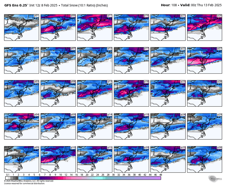
LWX AFD mentioned that the EPS min/max is quite wide... as low as an inch and as much as a foot across N VA
-
There shouldn't really be any overlap with snow accumulations today... here are the 12z GEFS individual members through 108. This is the closest I can get