yoda
-
Posts
63,221 -
Joined
Content Type
Profiles
Blogs
Forums
American Weather
Media Demo
Store
Gallery
Everything posted by yoda
-
 Eskimo Joe has been in... so I think we are at the top rung lol
 -
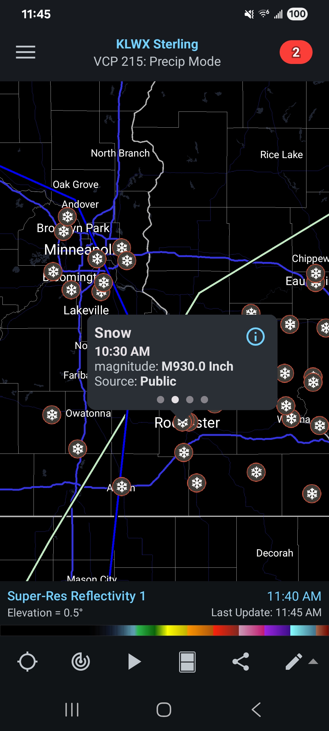
Well i guess we have a new weenie record in WI It's also on here for now - https://www.weather.gov/source/crh/snowmap.html?sid=mpx

-
Made it on here for now too lol https://www.weather.gov/source/crh/snowmap.html?sid=mpx

-
Alright, who decided to do a funny?

-
Day 2 Convective Outlook NWS Storm Prediction Center Norman OK 0107 AM CDT Sun Mar 15 2026 Valid 161200Z - 171200Z ...THERE IS A MODERATE RISK OF SEVERE THUNDERSTORMS FROM NORTHERN SOUTH CAROLINA ACROSS NORTH CAROLINA AND INTO VIRGINIA AND MARYLAND... ...SUMMARY... Widespread severe storms are forecast on Monday for parts of the Mid-Atlantic States and Southeast. Tornadoes, potentially strong, and particularly damaging winds are most likely from South Carolina into Maryland during the afternoon. Significant severe storm potential overall will extend from eastern Georgia/Florida Panhandle into Pennsylvania. ...Synopsis... A large and deepening upper trough will pivot northeastward out of the OH/TN Valleys, across the Appalachians and into the Mid Atlantic on Monday, while a surface low deepens into southern Quebec. A sharp pre-frontal trough will extend southward across NY, PA, and into the Carolinas/GA by late afternoon, with a corridor of significant pressure falls timed with the diurnal heating maximum. A cold front will push rapidly east across GA and the FL Panhandle during the day with a bit slower progress across the Piedmont and into PA. Gusty south winds ahead of the cold front will maintain 60s F dewpoints across the entire region, and as far north as southern PA, just after warm front passage by late afternoon. Just above the surface, southerly 850 mb winds will increase from 50 to 75 kt, resulting in extreme shear profiles over a large area. Large-scale ascent and shear will increase coincident with the peak heating hours, resulting in a potentially widespread severe weather event during the afternoon. ...From Georgia and the Florida Panhandle... Early day storms may be ongoing from the southern Appalachians toward the FL Panhandle Monday morning, and the environment will already be favorable for supercells including tornado potential. Forecast soundings indicate substantial instability with mid to perhaps upper 60s F along with ample shear. These storms may also produce hail, as midlevel lapse rates approach 7 C/km. ...Carolinas into MD/PA and vicinity... Areas of showers may occur early in the day especially but should rapidly lift north, allowing areas of heating and gradual destabilization over the entire area. As the surface trough deepens, low-level wind will back and strengthen throughout the day. Supercells producing tornadoes appear most likely ahead of the cold front from SC into NC and southern VA. Models vary with degree of instability, but strong tornadoes do appear possible with effective SRH of at least 300-400 m2/s2. Fast storm motions over 50 kt suggest a long tracked tornado will be possible. Meanwhile, a robust line of storms will develop as the cold front pushes east, stretching from the Carolinas to southern NY. With a moist air mass and large-scale support, this line is expected to produce particularly damaging winds, along with QLCS tornadoes across the remainder of SC/NC, VA, MD, and much of southern PA. This will likely peak during the late afternoon hours. The activity may eventually interact with cool trajectories off the Atlantic during the evening. ..Jewell.. 03/15/2026
- 331 replies
-
- 1
-

-
- severe
- thunderstorms
- (and 7 more)
-
- 331 replies
-
- 4
-

-

-
- severe
- thunderstorms
- (and 7 more)
-
Oh
- 331 replies
-
- 1
-
-
- severe
- thunderstorms
- (and 7 more)
-
Which using the new tables, means CIG 1 60 or CIG 2 45
-
I'd think so as well, but wouldn't be surprised if they go mod for wind in the morning update.
-
Question is will it be the morning or the afternoon day 2 lol
-
You beat me to my edit lol. I only went by the main page which showed mdt https://www.spc.noaa.gov/exper/archive/events/
-
There was a high risk that day in NC... mod risk was south of the LWX CWA looks like https://www.spc.noaa.gov/exper/archive/event.php?date=20110416
-
Up close look (h/t @canderson)
- 331 replies
-
- 3
-
-
- severe
- thunderstorms
- (and 7 more)
-
Oh my Day 3 Convective Outlook NWS Storm Prediction Center Norman OK 0238 PM CDT Sat Mar 14 2026 Valid 161200Z - 171200Z ...THERE IS AN ENHANCED RISK OF SEVERE THUNDERSTORMS FROM SC TO SOUTHERN PA... ...SUMMARY... Scattered to widespread severe storms are likely on Monday for parts of the Mid-Atlantic States and Southeast. The greatest potential for strong tornadoes and significant damaging winds appears centered on parts of South Carolina to Maryland during the late morning to afternoon. ...Mid-Atlantic and Southeast... Primary changes this outlook are to add a 45 total severe probability along with minor northeast and southeast expansion to the categorical risk areas. Portions of the region, centered on SC to MD, may warrant an upgrade to a level 4/Moderate Risk in later outlooks. A large and deepening upper trough will eject east/northeastward out of the MS/OH/TN Valleys and across the Appalachians and into the Mid Atlantic/Northeast on Monday, with an expansive area of strong to intense wind fields aloft. A deep cyclone will move from Lower MI into QC, with an occluding cold front arcing southeast across the northern Appalachians, then south-southwest into the northern Gulf. This front will clear all but the FL Peninsula by Monday evening. Ahead of the front, seasonably rich low-level moisture characterized by 60s surface dew points will spread northward from the eastern Gulf/western Atlantic. Convection will likely be ongoing at 12Z Monday, low-topped along the Upper OH Valley to central Appalachian portion of the front to deep convection in the lee of the southern Appalachians to eastern FL Panhandle. A diurnal uptick in storm intensity, including potential for semi-discrete supercells ahead of the front, should occur from north FL to the Carolina Piedmont. Further intensification is anticipated midday into the afternoon as a confined corridor of moderate buoyancy likely develops just ahead of morning storms. Enlarged low-level hodograph curvature, in conjunction with favorable elongation of the mid/upper hodograph, should foster a mix of broken supercells south with line-embedded supercells in the reinvigorated QLCS north. With such intense 700-mb flow aptly timed with the diurnal heating cycle overlying rich low-level moisture, setup could yield an expansive severe weather day, including strong tornadoes and significant damaging winds. The degree of boundary-layer heating, as well as timing of convection that may outpace the front late D2 into early D3, will play key roles in how intense severe magnitudes may become. At present, the most likely corridor for significant/widespread severe appears centered on the eastern Piedmont to coastal plain from SC to MD around midday into the afternoon. ..Grams.. 03/14/2026
-
Oh snap @Kmlwx @wxmeddler @high risk @Eskimo Joe
- 331 replies
-
- 4
-
-
- severe
- thunderstorms
- (and 7 more)
-
Afternoon day 3 from SPC
- 331 replies
-
- 1
-
-
- severe
- thunderstorms
- (and 7 more)
-
Afternoon AFD from LWX... @high risk i know you mentioned instability... LWX seems to be suggesting around 1K SBCAPE in the disco (bold mine) DISCUSSION... KEY MESSAGE 1...A strong cold front pushes across the forecast area Monday, bringing gusty winds and potential for severe thunderstorms capable of producing significant damaging winds and tornadoes. Precipitation chances begin increasing Sunday as a potent low pressure system traverses across the Great Lakes into Canada, pushing the associated fronts across the Mid-Atlantic. The associated warm front lifts through the area Sunday night with the cold front tracking across the region during the day Monday. Aloft, a robust trough digs across the central CONUS, becoming slightly negatively tilted as it approaches and pivots across the east coast Monday. This will push the aforementioned cold front across the forecast area, bringing impactful weather throughout the day. In the wake of the warm front lifting through Sunday night, high temperatures on Monday will be in the mid 60s to mid 70s. Additionally, with southerly flow, dewpoints rise into the upper 50s to low 60s across much of the forecast area ahead of the cold front. Storms may initiate Monday morning with any shower/storm capable of producing gusty winds due to a strong wind field aloft. Later Monday morning and into the afternoon, storms develop along the cold front as it moves through from west to east. Damaging winds are likely with severe storms capable of producing significant damaging wind and tornadoes. With such a strong wind field aloft, there is the potential for wind gusts of 70 to 80 mph within severe storms. Current model guidance shows 300-400 m2/s2 SRH and up to 1400 J/kg SBCAPE which is compatible with a tornado risk across the area. SPC has the forecast area along and east of the I-81 corridor in an enhanced risk for severe weather with the rest of the forecast area in a slight risk. PWATS will be seasonably high, although a fast storm motion limits the flooding risk.
-
I don't always chase tornadoes, but when I do, I zero-meter them
-
Those who know better can correct me... but 18z RRFS sim radar looks ugly. Looks like warm sector prefrontal sups appear in the afternoon with a QLCS right around sunset moving through the region
-
Also, not saying we will get one here, but the derecho definition has changed https://x.com/evan_bentley/status/2032572486982791628?s=20
-
LWX afternoon AFD DISCUSSION... KEY MESSAGE 1...A strong cold front will arrive Monday, bringing strong winds and the potential for severe thunderstorms. The Mid Atlantic should be in the warm sector of a powerful low pressure system over the Great Lakes on Monday. A deep upper trough pushing east of the Mississippi Valley will be taking on a negative tilt. Winds throughout the atmosphere will be very strong, along with notable low level wind shear (though more speed than direction). Dew points in the upper 50s to lower 60s and modest mid level lapse rates will limit instability but there should still be enough to support convection. The thermodynamic profile could be one of the primary factors into just how significant the severe weather is. There is some threat for some leading cellular development in the warm sector which could pose a wind and tornado risk. Then, a squall line is likely to develop ahead of the sharp cold front. Damaging winds, some potentially significant, will be a threat with the squall line. A QLCS tornado threat could also be present, although the shear vectors will be more parallel to the line vs. the more favorable perpendicular. Seasonally high precipitable water will also result in heavy rain, although storms will be moving quickly. Timing is still a bit uncertain, but the most favorable conditions combined with afternoon/early evening timing are projected east of the Blue Ridge. SPC has highlighted a somewhat rare 30 percent day 4 severe outlook for this area. Besides the convective winds, gradient winds will also be strong immediately ahead of and behind the front which could cause additional localized tree damage and/or complicate recovery efforts. Cold air will be rushing in immediately following the frontal passage. At a minimum, the Allegheny Mountains will change to snow for a time in upslope conditions. It remains uncertain if any postfrontal precip lingers to the east long enough to change over.
-
They don't... unless absolutely necessary
- 331 replies
-
- 3
-
-
- severe
- thunderstorms
- (and 7 more)