yoda
-
Posts
61,400 -
Joined
Content Type
Profiles
Blogs
Forums
American Weather
Media Demo
Store
Gallery
Everything posted by yoda
-
00z HRRR and 02z HRRR bring a line through of cells around 20z
-
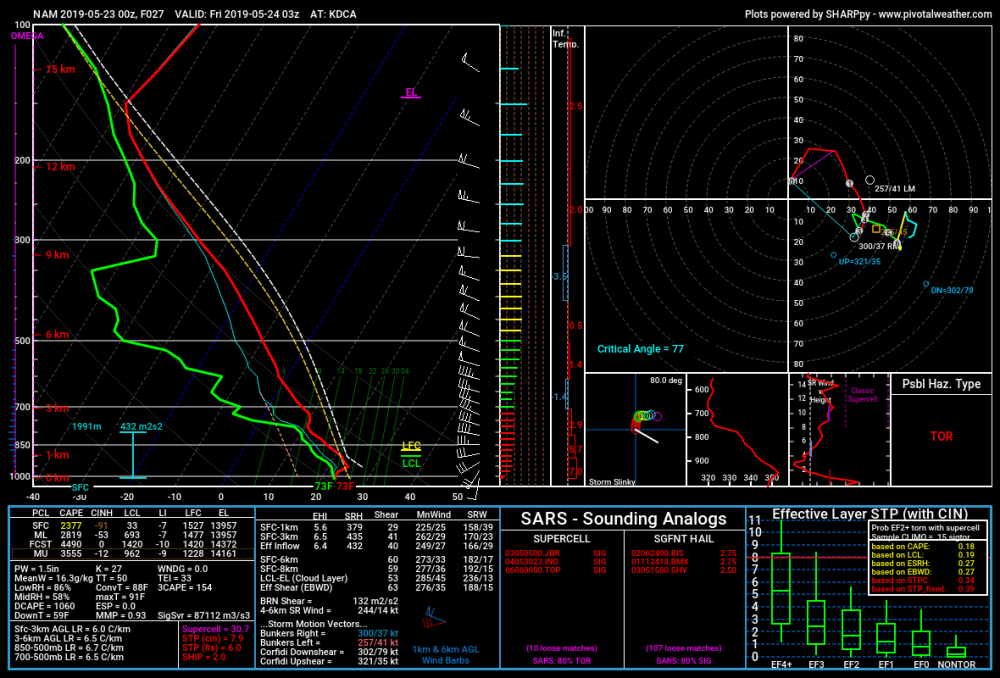
Another view of the sounding at DCA at 03z FRI per pivotalweather
-
00z NAM NEST decides to drive through some what would appear to be supercells around 20z to 21z... then brings a pretty decent line south from PA as a finale around 03z but its fragmenting around DC at that time
-
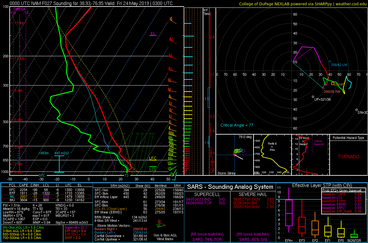
Oh hai... sounding around DCA at 03z FRI per the 00z NAM

-
00z NAM sim radar brings some nastiness for the evening commute from BWI to DCA to near EZF at 21z
-
Ok... those are some disturbing soundings the 00z NAM is tossing out at 00z and 03z FRI at KIAD... 03z FRI at KBWI and KDCA... Yes, just a sounding, but you don't see those types of soundings around here very often Yes, doesn't guarantee we see severe. But still... wow @Kmlwx @high risk
-

2019 Short/Medium Range Severe Weather Thread
yoda replied to snowlover2's topic in Lakes/Ohio Valley
Tornado Warning in NE MO for Marion and Shelby counties -
18z NAM soundings at 21z THUR and 00z FRI are pretty impressive across the region
-
I think it will continue to look that way on sim radar until the MCS that LWX mentioned in the afternoon AFD develops
-
LWX's afternoon AFD re tomorrow from 2:30PM
-
SPC Disco from the 1730 OTLK
-
1730 SPC OTLK moves the SLGT and ENH risk south some compared to earlier Day 2
- 2,802 replies
-
- 2
-

-
- severe
- thunderstorms
- (and 4 more)
-
I'm liking Thursday based off the NAM/NAM NEST/SREFs... I see the slight risk moving south some on the new Day 2 and an ENH in PA.
- 2,802 replies
-
- 1
-
-
- severe
- thunderstorms
- (and 4 more)
-
00z NAM soundings at 21z THUR and 00z FRI look tasty
-
Lol there could be a high risk here and @Eskimo Joe would find a way to meh it
- 2,802 replies
-
- 2
-
-
- severe
- thunderstorms
- (and 4 more)
-
LWX afternoon AFD on Thursday afternoon threat:
-
I wonder if that action on sim reflectivity in SW PA/W MD would reach us in the few hours after the 12z NAM NEST run ends
-
12z NAM soundings look good as well IMO, esp between 21z THUR and 03z FRI
-
2019 Atlantic Hurricane Season
yoda replied to AfewUniversesBelowNormal's topic in Tropical Headquarters
ZCZC MIATWOAT ALL TTAA00 KNHC DDHHMM Special Tropical Weather Outlook NWS National Hurricane Center Miami FL 550 PM EDT Mon May 20 2019 For the North Atlantic...Caribbean Sea and the Gulf of Mexico: 1. Data from an Air Force Reserve reconnaissance aircraft indicate that the low pressure system located several hundred miles southwest of Bermuda has developed a well-defined center with maximum sustained winds of about 40 mph. A special advisory will be issued on Subtropical Storm Andrea by 6:30 PM EDT or 2230 UTC. * Formation chance through 48 hours...high...near 100 percent. * Formation chance through 5 days...high...near 100 percent. Forecaster Zelinsky/Cangialosi -
2019 Atlantic Hurricane Season
yoda replied to AfewUniversesBelowNormal's topic in Tropical Headquarters
STS Andrea has formed -
12z NAM looks okay I guess for Thursday afternoon
-
12z looked same as 00z I guess re CIPS?
-
2 inch hail marker on radarscope and maybe some slight rotation?
-
STW till 9pm for NW portions of the LWX CWA
-
Clear Spring MD about to be crushed