yoda
-
Posts
61,405 -
Joined
Content Type
Profiles
Blogs
Forums
American Weather
Media Demo
Store
Gallery
Everything posted by yoda
-
tomorrow
-
Might be our first day of HX around 100... the AFD mentioned that as well
-
That makes sense... thanks
- 2,802 replies
-
- 1
-

-
- severe
- thunderstorms
- (and 4 more)
-
Also decent SRH(near 200)... so maybe some embedded sups or mesovorticies?
-
You sort of win... but its 5/30/30 for N VA and DC and MD into S PA
-
Both 01z and 02z HRRR at the very end of their runs have storms exploding across the region around 19z
-
00z NAM sim radar keeps us dry all day until a bow echo or squall line comes dropping in between 00z and 03z THUR 00z NAM also shows some nice ML Lapse rates in the evening as well
-
I'm sure this has been discussed in this thread already... but this is super awesome
- 2,802 replies
-
- 3
-
-
- severe
- thunderstorms
- (and 4 more)
-
For our DE and MD peeps who are in PHL CWA but post here WATCH COUNTY NOTIFICATION FOR WATCH 274 NATIONAL WEATHER SERVICE MOUNT HOLLY NJ 533 PM EDT TUE MAY 28 2019 DEC001-003-005-MDC011-015-029-035-041-NJC001-009-011-033-290200- /O.EXA.KPHI.TO.A.0274.000000T0000Z-190529T0200Z/ THE NATIONAL WEATHER SERVICE HAS EXTENDED TORNADO WATCH 274 TO INCLUDE THE FOLLOWING AREAS UNTIL 10 PM EDT THIS EVENING IN DELAWARE THIS WATCH INCLUDES 3 COUNTIES IN CENTRAL DELAWARE KENT IN NORTHERN DELAWARE NEW CASTLE IN SOUTHERN DELAWARE SUSSEX IN MARYLAND THIS WATCH INCLUDES 5 COUNTIES IN NORTHEAST MARYLAND CAROLINE CECIL KENT QUEEN ANNE`S TALBOT IN NEW JERSEY THIS WATCH INCLUDES 4 COUNTIES IN SOUTHERN NEW JERSEY ATLANTIC CAPE MAY CUMBERLAND SALEM THIS INCLUDES THE CITIES OF ATLANTIC CITY, CENTREVILLE, CHESTERTOWN, DENTON, DOVER, EASTON, ELKTON, GEORGETOWN, HAMMONTON, MILLVILLE, OCEAN CITY, PENNSVILLE, AND WILMINGTON.
- 2,802 replies
-
- 3
-
-
- severe
- thunderstorms
- (and 4 more)
-
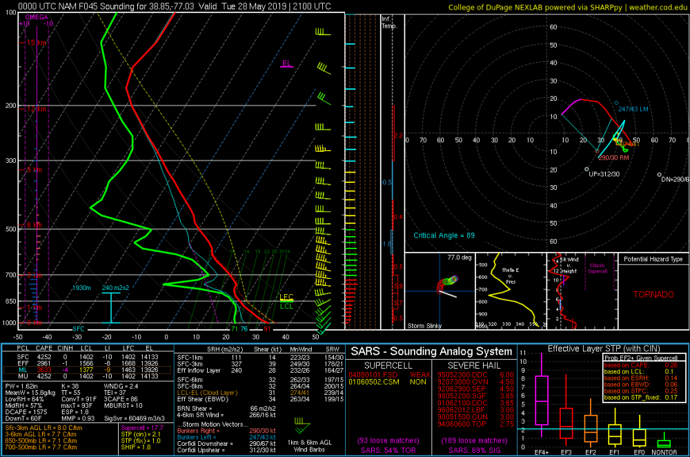
Hmmm Mesoscale Discussion 0861 NWS Storm Prediction Center Norman OK 0434 PM CDT Tue May 28 2019 Areas affected...Portions of northern Virginia into Maryland and Delaware Concerning...Tornado Watch 274... Valid 282134Z - 282300Z The severe weather threat for Tornado Watch 274 continues. SUMMARY...Severe potential increasing across portions of eastern Maryland into Delaware and southern New Jersey, both with supercells approaching from the northwest in Pennsylvania, and with the initiation of discrete convection along the Maryland border. Large hail and damaging winds will be the primary concerns, but an isolated tornado is also possible. DISCUSSION...Multiple supercell structures are in progress across central Pennsylvania, several with a history of severe hail and damaging wind gusts. These storms will continue to propagate southeastward into an environment characterized by moderate instability (1500-2500 J/kg MLCAPE) and adequate deep-layer shear (bulk effective shear values of 40-50 knots). Low-level speed and directional shear are adequate for supporting a continuance of supercell structures given the moderate buoyancy present, though the overall magnitudes of low-level shear suggests that large hail will be the main threats. A few stones may exceed 2.0 inches in diameter as well. Rain/hail loaded downdrafts may also induced damaging wind gusts. One of the stronger, more sustained supercell structures may also spawn a tornado or two, especially with storms farther to the northeast, where low-level directional shear is slightly more favorable for supporting sustained, low-level rotation. ..Squitieri/Hart.. 05/28/2019 ...Please see www.spc.noaa.gov for graphic product... ATTN...WFO...PHI...AKQ...CTP...LWX...
-
18z NAM NEST looks interesting... sups at 20z?
-
Refreshing the 18z NAM soundings
-
I might stay up to see the new Day 1 tonight lol
-
IF (a big IF) something gets toward the M/D line, I could see LWX adding a few counties to the watch later this evening... or is it SPC that does that?
- 2,802 replies
-
- 1
-
-
- severe
- thunderstorms
- (and 4 more)
-
Guess Eskimo Joe loses $20
-
Tornado Watch issued to our north... no LWX counties in it... 50/20 probs on TOR
-
Woah... 1730 SPC discussion is
-
Appears you have made a good call about tomorrow... entire LWX CWA included in SLGT risk in 1730 SPC OTLK... ENH risk for all of S PA and all of MD and N VA and DC
-
Do you know if LWX is doing one? Or since they are barely out of SLGT they will not do one?
-
SLGT risk includes all of C and N MD on the 1630 OTLK... so that is probably why
-

2019 Hurricane (all named Tropical storms) forecast contest
yoda replied to Roger Smith's topic in Tropical Headquarters
13/7/2 May 1/0/0 June 1/0/0 July 1/1/0 August 3/2/0 September 4/3/2 October 3/1/0 November/December 0/0/0 -
That sucks... pure blue sky here with lots of sun. Hopefully the clouds will clear shortly so you can get in on the sun
-
Updated morning AFD seems to think there is at least an isolated risk to the DC metro region -- the zones (updated as of 10:30am) also have the severe wording into the DC Metro as well
-
I'm confused... does this mean that the GFS is better for us than the NAM because the front moves toward us faster?
-
SARS is off the charts silly for hail at 21z TUES at KDCA