yoda
-
Posts
60,262 -
Joined
Content Type
Profiles
Blogs
Forums
American Weather
Media Demo
Store
Gallery
Everything posted by yoda
-
84 near or right over ORF at 1002mb
-
Hmmm IWM at 81 has SLP in NC...
-
18z GFS is very nice... 2 to 4 for all just about Ninja'd by WxUSAF
-
Looks nothing like what LWX has
-

The March Long Range Discussion Thread, Winter's Last Stand
yoda replied to stormtracker's topic in Mid Atlantic
Why? I don't see anything on the CMC/GFS that stand out -
12z FV3 looks close to what the GFS says
-
Cold rain for most... perhaps snow for W MD into parts of C MD and for those along M/D line per 12z GFS
-
Looks slightly more amped than 6z
-
The March Long Range Discussion Thread, Winter's Last Stand
yoda replied to stormtracker's topic in Mid Atlantic
Posted in your March 2019 thread in your subforum -
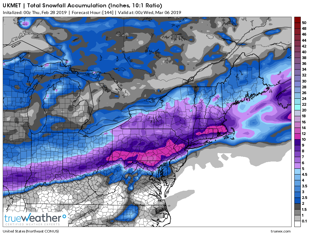
00z UKIE looks almost exactly like the 00z RGEM if you believe the snowmap
-
00z run is actually a lil better for DC and N VA compared to 18z... the HRDPS that is
-
The March Long Range Discussion Thread, Winter's Last Stand
yoda replied to stormtracker's topic in Mid Atlantic
00z GFS slightly warmer... best chance of snows out towards i81 and western Maryland -
Kuchera is actually a tad higher FWIW
-
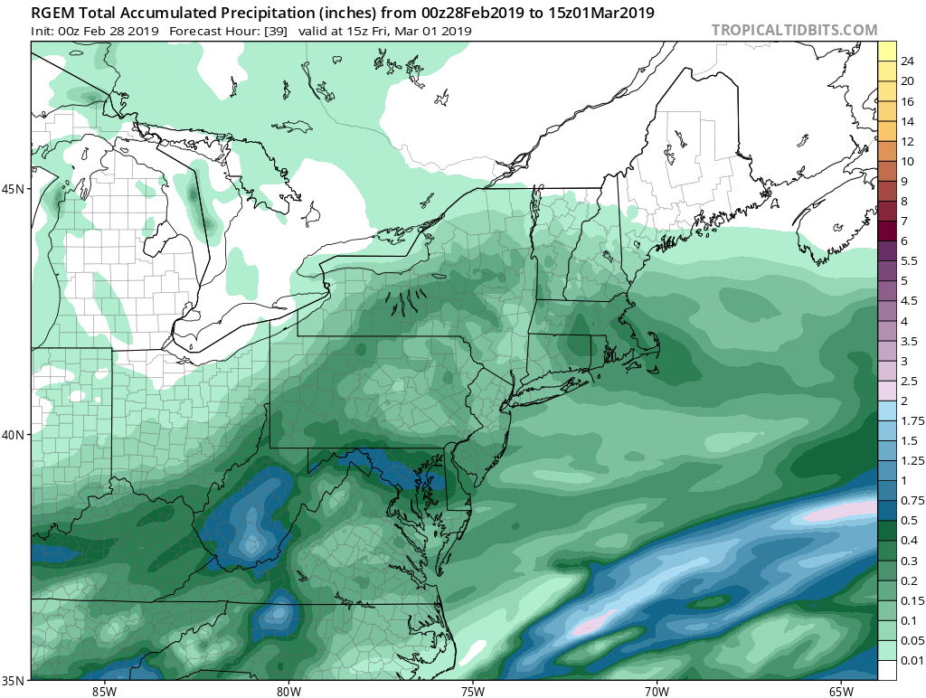
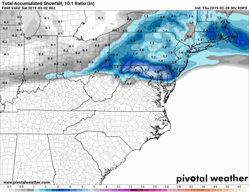
00z RGEM crushes C MD to DC
-
The March Long Range Discussion Thread, Winter's Last Stand
yoda replied to stormtracker's topic in Mid Atlantic
Only thing I can see right away is def higher heights out in front comparing 00z at 78 hours to 18z at 84 hours on the h5 map (look at the 552DM and 558DM lines) -
The March Long Range Discussion Thread, Winter's Last Stand
yoda replied to stormtracker's topic in Mid Atlantic
FWIW, 00Z NAM at 84 has 1008mb SLP near Dallas, TX -
The March Long Range Discussion Thread, Winter's Last Stand
yoda replied to stormtracker's topic in Mid Atlantic
Lol -
The March Long Range Discussion Thread, Winter's Last Stand
yoda replied to stormtracker's topic in Mid Atlantic
The mag website had the 2mT line pretty close by and the 850 0c line stayed just south of DC... most be warm layers elsewhere. Still, pretty close to a big hit -
The March Long Range Discussion Thread, Winter's Last Stand
yoda replied to stormtracker's topic in Mid Atlantic
FV3 big hit for EZF north -
I like the 4" stripe in N VA
-
06z GFS was around an inch for some... FV3 is a solid 2" for many across the region
-
The March Long Range Discussion Thread, Winter's Last Stand
yoda replied to stormtracker's topic in Mid Atlantic
Surprised Ji hasn't been posting about the 00z Euro being a disaster for Sunday into Monday... nice large rainstorm -
The March Long Range Discussion Thread, Winter's Last Stand
yoda replied to stormtracker's topic in Mid Atlantic
FV3 likes the Monday threat and doesn't like the midweek one -
The March Long Range Discussion Thread, Winter's Last Stand
yoda replied to stormtracker's topic in Mid Atlantic
FV3 would be a WSW storm lol for early Monday