yoda
-
Posts
63,700 -
Joined
Content Type
Profiles
Blogs
Forums
American Weather
Media Demo
Store
Gallery
Everything posted by yoda
-
Tornado Warning VAC067-089-143-690-130930- /O.NEW.KRNK.TO.W.0003.200413T0901Z-200413T0930Z/ BULLETIN - EAS ACTIVATION REQUESTED Tornado Warning National Weather Service BLACKSBURG VA 501 AM EDT Mon Apr 13 2020 The National Weather Service in BLACKSBURG has issued a * Tornado Warning for... Northwestern Pittsylvania County in south central Virginia... The City of Martinsville in south central Virginia... Central Henry County in south central Virginia... Eastern Franklin County in west central Virginia... * Until 530 AM EDT. * At 501 AM EDT, a severe thunderstorm capable of producing a tornado was located over Martinsville, moving northeast at 55 mph. HAZARD...Tornado. SOURCE...Radar indicated rotation. IMPACT...Flying debris will be dangerous to those caught without shelter. Mobile homes will be damaged or destroyed. Damage to roofs, windows, and vehicles will occur. Tree damage is likely. * Locations impacted include... Martinsville... Sydnorsville... Penhook... Snow Creek... Leatherwood... Villa Heights... and Chatmoss. This includes The following Locations The Martinsville Speedway and Martinsville Airport.
-
New TOR Watch coming soon for S VA into NC = https://www.spc.noaa.gov/products/md/md0377.html Mesoscale Discussion 0377 NWS Storm Prediction Center Norman OK 0340 AM CDT Mon Apr 13 2020 Areas affected...Parts of central and eastern North Carolina into southern Virginia Concerning...Severe potential...Watch likely Valid 130840Z - 131015Z Probability of Watch Issuance...95 percent SUMMARY...Severe weather potential with an evolving squall line is expected to increase across the region through daybreak and beyond, accompanied by the risk for damaging wind gusts and a few tornadoes. DISCUSSION...The southern portion of a deepening elongated surface cyclone, centered over the Great Lakes, will continue to shift across and east of the Appalachians through 11-13Z, ahead of the remnants of a vigorous short wave impulse approaching the Appalachians. Aided by strengthening southerly low-level flow, including 50-70 kt at 850 mb, moisture return is ongoing across much of the southern Mid Atlantic. Surface dew points are now rising through the mid/upper 60s across much of central and eastern North Carolina, and this moisture is expected to continue to advect northward ahead of the evolving squall line, into much of southern/eastern Virginia through daybreak into mid/late morning. This will contribute to boundary-layer destabilization sufficient to support at least the maintenance of vigorous convection, with continuing intensification possible, accompanied by the the risk for damaging wind gusts and a few embedded tornadoes. ..Kerr/Thompson.. 04/13/2020 ...Please see www.spc.noaa.gov for graphic product... ATTN...WFO...AKQ...MHX...RAH...ILM...RNK...CAE...
-
down the road a few hours for us maybe... BULLETIN - IMMEDIATE BROADCAST REQUESTED Severe Thunderstorm Warning National Weather Service BLACKSBURG VA 435 AM EDT Mon Apr 13 2020 The National Weather Service in BLACKSBURG has issued a * Severe Thunderstorm Warning for... Stokes County in north central North Carolina... Western Rockingham County in north central North Carolina... Eastern Yadkin County in northwestern North Carolina... Southwestern Campbell County in central Virginia... Western Pittsylvania County in south central Virginia... The City of Martinsville in south central Virginia... South central Bedford County in south central Virginia... Henry County in south central Virginia... Southeastern Franklin County in west central Virginia... Southeastern Patrick County in southwestern Virginia... * Until 530 AM EDT. * At 435 AM EDT, severe thunderstorms were located along a line extending from near Sontag to near Clemmons, moving northeast at 35 mph. HAZARD...60 mph wind gusts. SOURCE...Radar indicated. IMPACT...Expect damage to roofs, siding, and trees. * Locations impacted include... Eden... Martinsville... Rocky Mount... Altavista... Wentworth... Mayodan... and Madison. This includes The following Locations The Martinsville Speedway and Martinsville Airport.
-
-
Short Term Forecast National Weather Service Baltimore MD/Washington DC 412 AM EDT Mon Apr 13 2020 DCZ001-MDZ013-504-506-VAZ053-054-130900- District of Columbia-Central and Southeast Montgomery-Prince Georges-Central and Southeast Howard-Fairfax-Arlington/Falls Church/Alexandria- 412 AM EDT Mon Apr 13 2020 ...VERY HEAVY RAIN WILL MOVE ACROSS THE WASHINGTON METRO AREA... At 4 AM EDT, very heavy rain was moving northeast out of northern Virginia into the Washington metro area. As it moves through, this will cause hazardous driving conditions and poor drainage flooding between 4 and 6 this morning. Do not drive your vehicle through flooded roadways.
-
LWX morning disco on our threat
-
Thats new (re bolded)... never seen that before BULLETIN - IMMEDIATE BROADCAST REQUESTED Severe Thunderstorm Warning National Weather Service Pittsburgh PA 357 AM EDT Mon Apr 13 2020 The National Weather Service in Pittsburgh has issued a * Severe Thunderstorm Warning for... Garrett County in western Maryland... Tucker County in northeastern West Virginia... Preston County in northeastern West Virginia... * Until 500 AM EDT. * At 356 AM EDT, the back end of severe showers and isolated thunderstorms were located along a line extending from 6 miles northwest of Newburg to near Belington, moving northeast at 65 mph. HAZARD...Wind gusts to 65 mph. SOURCE...Radar. IMPACT...Expect damage to trees and power lines, resulting in some power outages. * Locations impacted include... Kingwood... Mountain Lake Park... Oakland... Parsons... Terra Alta... Davis... Thomas... Rowlesburg... Bittinger... Grantsville... Loch Lynn Heights... Friendsville... This includes the following highways... Interstate 68 in Maryland between mile markers 1 and 29. Interstate 68 in West Virginia between mile markers 17 and 32.
-
DPs are approaching 60 on southerly winds across the region - https://forecast.weather.gov/product.php?site=lwx&issuedby=LWX&product=RWR
-
Tornado Watch(es) coming soon in NC -- https://www.spc.noaa.gov/products/md/md0373.html
-
Really?
-
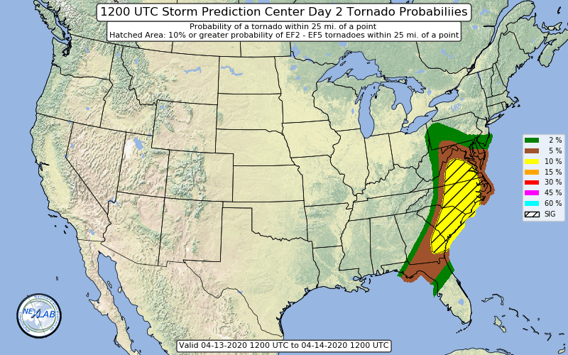
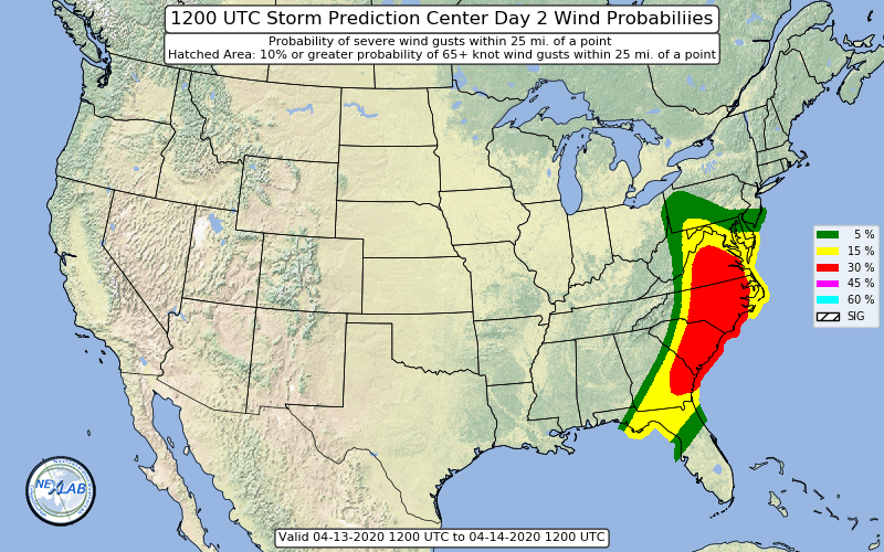
So ENH risk (because of wind)... I'll go big... as usual lol... 10% TOR hatched, 15% hail, 30 % wind hatched
-
DPs beginning to rise through the 50s across the region
-
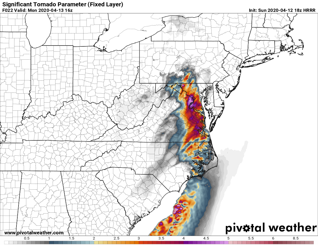
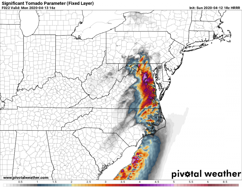
23z HRRR sounding at DCA at 16z MON
-
FWIW, 23z HRRR really pumps the SBCAPE in the late morning into early afternoon... 2000+ SBCAPE... you can start seeing the increased surface instability grow as soon as 14z in the SW portions of the LWX CWA
-
Hmmm... LWX keeps upgrading the Wind Advisory to HWW for more and more counties... first it was St. Marys and Calvert at 430ish... just now updated again and now includes PG/Charles/King George VA/AA counties ETA: This was reason why at 430 St. Mary's and Calvert were added to HWW per the AFD:
-
sorry, what do you mean by "safe" spot?
-
Impressive... most impressive
-
Seems like LWX is going for it in afternoon disco
-
Its probably like 20 miles S of me lol... but I would expect it to come north more tomorrow tbh. But that would depend on what goes on in the SE and western Carolinas tonight
-
10% hatched tor is now literally just south of DC metro... EZF is included
-
-
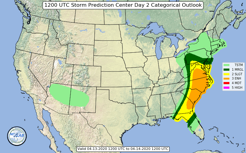
New Day 2 is out... ENH reaches up to around EZF... 10% hatched TOR includes CHO/RIC and is also just south of EZF
-
18z EURO was pretty nice per @losetoa6 re SBCAPE
-
45 now into DC... 60 getting closer to EZF on 21z SREFs
-
Even cutting in half... still ridiculous