yoda
-
Posts
60,262 -
Joined
Content Type
Profiles
Blogs
Forums
American Weather
Media Demo
Store
Gallery
Everything posted by yoda
-
18z HRRR at LR, so take it FWIW, but that radar image doesnt look good around 03z to 04z... string of sups
- 2,802 replies
-
- 1
-

-
- severe
- thunderstorms
- (and 4 more)
-
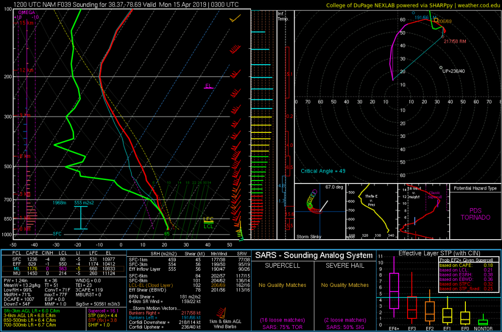
12z NAM NEST also has PDS TOR soundings showing up across LWX CWA from 00z to 08z MON
- 2,802 replies
-
- 2
-

-
-
- severe
- thunderstorms
- (and 4 more)
-
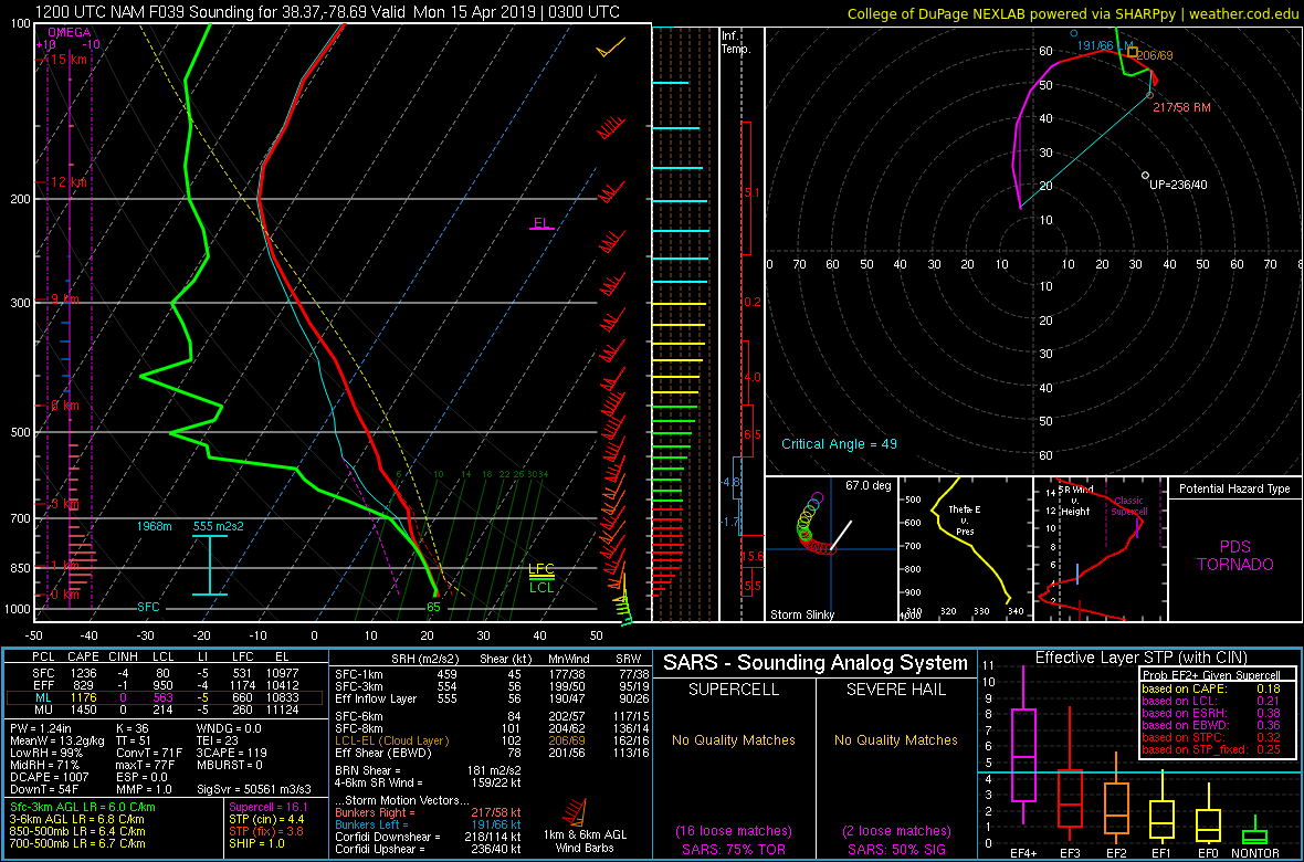
12z NAM in Augusta/Rockingham counties at 03z MON
- 2,802 replies
-
- 1
-
-
- severe
- thunderstorms
- (and 4 more)
-
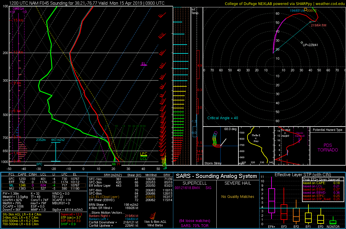
12z NAM in SW St. Mary's County at 09z MON

- 2,802 replies
-
- 1
-
-
- severe
- thunderstorms
- (and 4 more)
-
@Kmlwx @high risk SPC 12z HREF ensemble mean paints fixed layer STP of 4 to 7 across the region from around 03z to 08z MON Also shows 40% or greater ensemble probability of fixed layer STP >3 from 03z to 08z MON
- 2,802 replies
-
- 1
-
-
- severe
- thunderstorms
- (and 4 more)
-
Falling asleep - yes I know its 4am - and a loud rumble of thunder woke me back up
-
Sabine Parish storm in NW LA had a hail marker for tennis to baseball size and was mentioned in the STW out for the area... that's a very rude awakening
-
Tornado warning issued by KSJT for Crockett county
-
Tornado Watch up till 9am CDT in Southwestern Texas https://www.spc.noaa.gov/products/watch/ww0049.html Severe Tstorm Watch until 9am CDT also up in W Texas... above the Tornado Watch https://www.spc.noaa.gov/products/watch/ww0048.html
-
Storms firing with large hail already in LA
-
New Day 2 has SLGT almost to the i95 corridor and west for late Sunday into Sunday night
-
Looks like a Tornado Watch coming shortly potentially in SW TX https://www.spc.noaa.gov/products/md/md0312.html
-
I'd hold off on the 0600 OTLK and go mod but mention chance for upgrade to high... wait to see how the early morning starts out. Go for it at 1300 OTLK if everything is coming together... 1300 is 9am so people will be getting up around then and will see and hear about it on the morning news
-
Hmmm... new trailer for the last Star Wars movie (Episode IX - now known as The Rise of Skywalker) is interesting... but that's def Emperor Palpatine's laugh at the end
-
Do you have a link to that? That doesn't look good at all
-
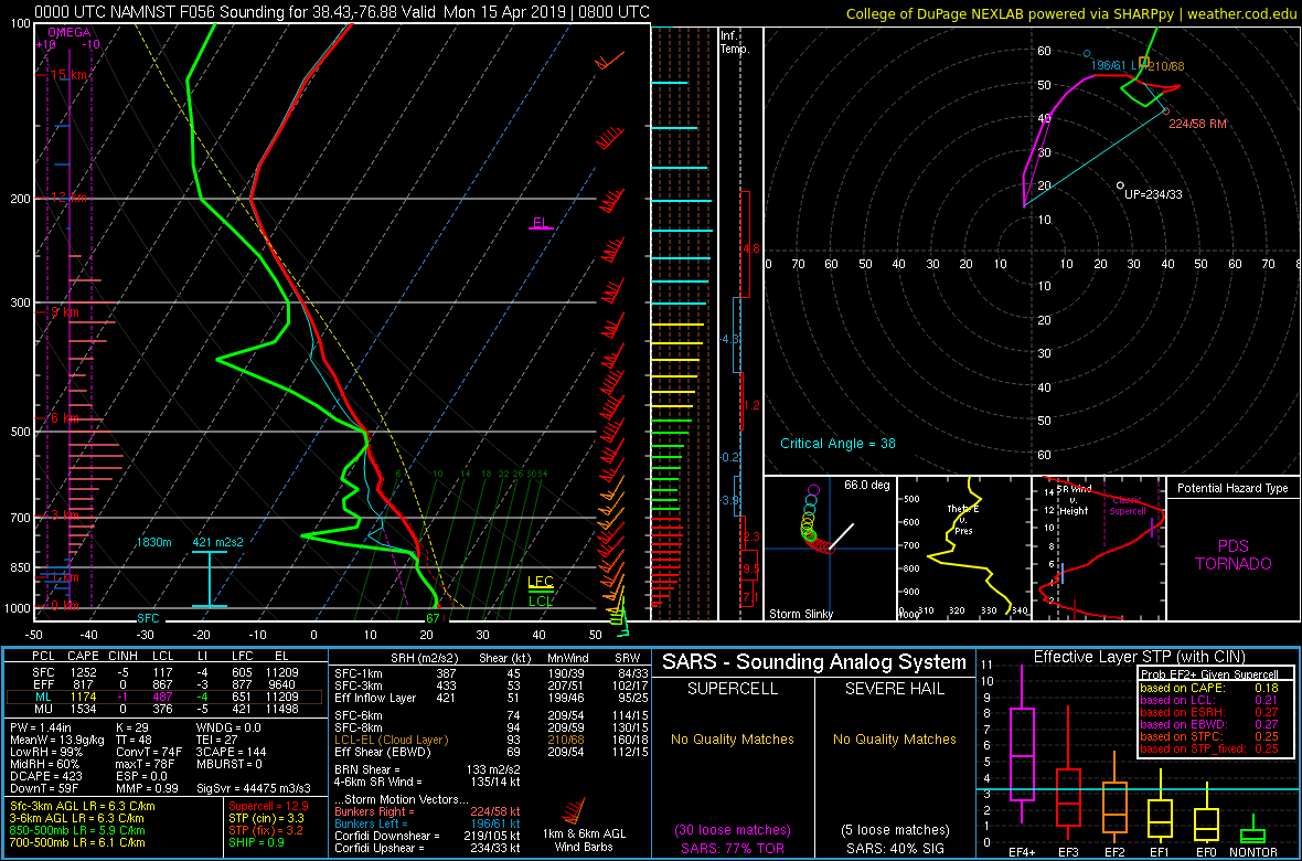
Charles County MD at 08z MON aka La Plata tornado zone from the 00z NAM NEST

-
Def agree and good post. I edited my post above and posted a sounding at 03z MON a little bit NW of CHO... prob overdone but PDS TOR lol
-
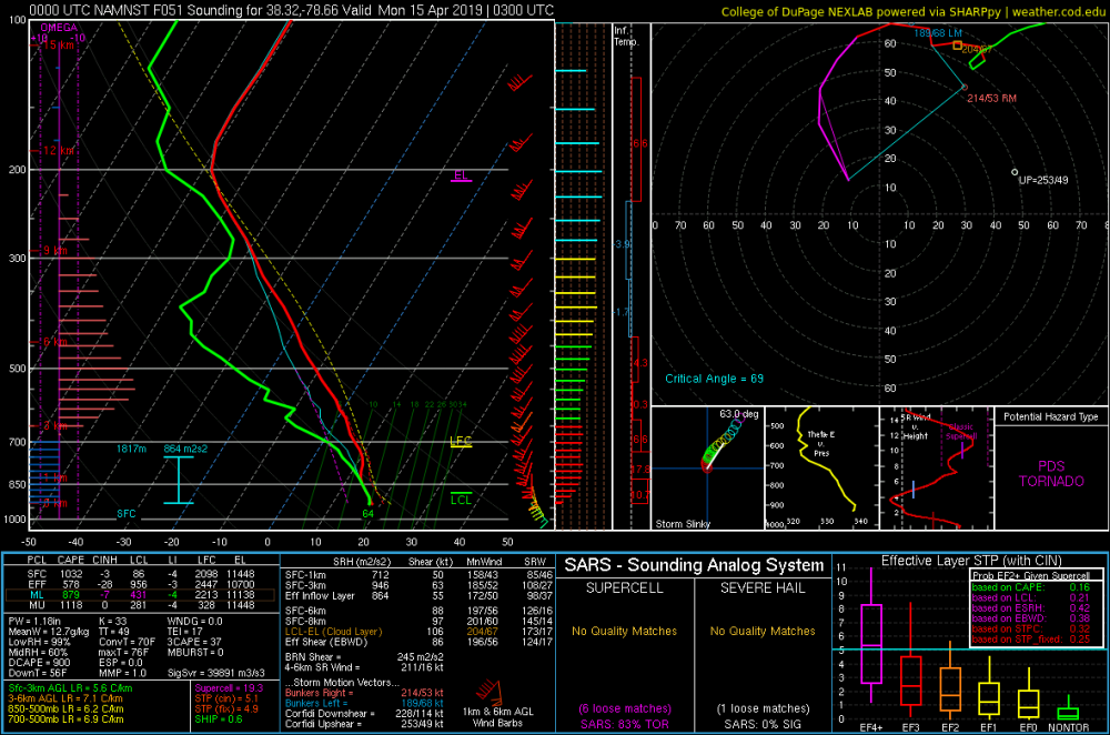
Just NW of CHO... Rockingham/Greene/Albermarle county area... first of the year lol
- 2,802 replies
-
- 1
-
-
- severe
- thunderstorms
- (and 4 more)
-
@high risk What do you think of the 00z NAM NEST tonight? STP looks to be pretty high across the region from 02z to 08z MON... looking at it on weather.cod.edu
-
TOG near Fuquay-Varina... was decent for a moment looking at CC ETA: Solak posted image above
-
Tree damage reported in Cumberland with the severe thunderstorm in W MD
-
STW up in W MD and extreme N WV... winds to 60mph
-
Afternoon AFD from LWX seems to hint at that:
-
Still MOD on day 2... doesn't look like they shifted the ENH risk west any
-
I expect there to be one on the 0600 DAY 1 OTLK... just saying that I would be a lil suprised to see SPC go HIGH on the 1730 Day 2.