

yoda
-
Posts
60,267 -
Joined
Content Type
Profiles
Blogs
Forums
American Weather
Media Demo
Store
Gallery
Everything posted by yoda
-
Tornado Watch in effect till 3am
-
Mesoscale Discussion 0347 NWS Storm Prediction Center Norman OK 0350 PM CDT Sun Apr 14 2019 Areas affected...Areas near/east of the Blue Ridge of North Carolina into Virginia Concerning...Tornado Watch 62... Valid 142050Z - 142215Z The severe weather threat for Tornado Watch 62 continues. SUMMARY...The risk for supercells potentially capable of producing tornadoes continues, and could increase at least a bit further through 6-7 PM EDT. Trends will also continue to be monitored for northward development toward the northern Virginia vicinity, which may require an additional severe weather watch. DISCUSSION...A zone of enhanced near/surface warm advection and convergence to the lee of the Blue Ridge mountains may remain a focus for discrete thunderstorm development across North Carolina into Virginia through the 22-23Z time frame. Aided by peak boundary layer instability associated with daytime heating (including CAPE up to 1000 J/kg), a few supercells are possible, in the presence of strong low-level and deep layer vertical shear. The Rapid refresh suggests that southwesterly 850 mb flow may continue to strengthen in excess of 50 kt, contributing to further enlargement of low-level hodographs and perhaps increasing tornadic potential. ..Kerr.. 04/14/2019 ...Please see www.spc.noaa.gov for graphic product... ATTN...WFO...AKQ...LWX...RAH...RNK...GSP...
-
MD out... watch possible soon
-
Tornado Watch within the hour for W PA - https://www.spc.noaa.gov/products/md/md0344.html
-
Wonder if that 10% TOR will be expanded at all on the 2000 SPC OTLK
-
Tornado Watch till 8pm for SW VA... includes the RNK counties that just about border the LWX CWA... Lynchburg is in the watch... just SW of CHO
-
BULLETIN - EAS ACTIVATION REQUESTED Tornado Warning National Weather Service Birmingham AL 116 AM CDT SUN APR 14 2019 The National Weather Service in Birmingham has issued a * Tornado Warning for... Northwestern Perry County in central Alabama... Southeastern Hale County in west central Alabama... * Until 215 AM CDT. * At 116 AM CDT, a severe thunderstorm capable of producing a tornado was located near Chickasaw State Park, or near Demopolis, moving northeast at 45 mph. HAZARD...Tornado. SOURCE...Radar indicated rotation. IMPACT...Flying debris will be dangerous to those caught without shelter. Mobile homes will be damaged or destroyed. Damage to roofs, windows, and vehicles will occur. Tree damage is likely. * Locations impacted include... Greensboro, Newbern, Arcola, Heiberger, Greensboro Municipal Airport, Morgan Springs, Gallion, Wateroak, Cedarville, Laneville, Folsom and Ellards.
-
BULLETIN - IMMEDIATE BROADCAST REQUESTED Severe Thunderstorm Warning National Weather Service Mobile AL 114 AM CDT Sun Apr 14 2019 The National Weather Service in Mobile has issued a * Severe Thunderstorm Warning for... Choctaw County in southwestern Alabama... Northeastern Wayne County in southeastern Mississippi... * Until 200 AM CDT. * At 113 AM CDT, a severe thunderstorm was located 5 miles northeast of Waynesboro, moving northeast at 55 mph. This storm is rotating and could produce a tornado. HAZARD...60 mph wind gusts. SOURCE...Radar indicated. IMPACT...Expect damage to roofs, siding, and trees. * Locations impacted include... Butler, Lisman, Pennington, Gilbertown and Toxey.
-
Must not be down into the lower levels as of yet since the SWS from KBMX issued just now still has it as "severe thunderstorm capable of producing a tornado"
-
KBMX just issued a Tornado Warning for NW Tuscaloosa County in AL
-
Mesoscale Discussion 0333 NWS Storm Prediction Center Norman OK 1239 AM CDT Sun Apr 14 2019 Areas affected...portions of Middle Tennessee...northeastern/eastern Alabama...and northwestern Georgia Concerning...Tornado Watch 55... Valid 140539Z - 140645Z The severe weather threat for Tornado Watch 55 continues. SUMMARY...Either a new Tornado Watch or a replacement Tornado Watch for WW 55 will be issued soon. DISCUSSION...An ongoing broken band of convection extends from northwestern Alabama near MSL southward to near CBM and onward from there toward the Mississippi Gulf Coast. A weakly unstable, yet strongly sheared airmass extends just east of this band, spreading into southern portions of Middle Tennessee. This airmass should support a continued tornado threat as deeper convection moves north-northeastward into the region. As such, either a new Tornado Watch or a replacement Tornado Watch (replacing WW 55) will be coordinated with affected offices within the next 15 minutes or so. ..Cook/Edwards.. 04/14/2019 ...Please see www.spc.noaa.gov for graphic product... ATTN...WFO...MRX...FFC...OHX...BMX...HUN...
-
Confirmed TOG near Tishomingo State Park per KHUN in SWS (Colbert and Franklin counties)
-
Thats so sad... I hope there aren't any fatalities and everyone is rescued that needs to be
-
BULLETIN - EAS ACTIVATION REQUESTED Tornado Warning National Weather Service Memphis TN 1140 PM CDT Sat Apr 13 2019 The National Weather Service in Memphis has issued a * Tornado Warning for... Eastern Itawamba County in northeastern Mississippi... Southern Tishomingo County in northeastern Mississippi... * Until 1215 AM CDT. * At 1140 PM CDT, a confirmed large and extremely dangerous tornado was located near New Salem, or 12 miles southeast of Fulton, moving north at 50 mph. This is a PARTICULARLY DANGEROUS SITUATION. TAKE COVER NOW! HAZARD...Damaging tornado. SOURCE...Radar confirmed tornado. IMPACT...You are in a life-threatening situation. Flying debris may be deadly to those caught without shelter. Mobile homes will be destroyed. Considerable damage to homes, businesses, and vehicles is likely and complete destruction is possible. * Locations impacted include... Fulton, Belmont, Tremont, Fairview, New Salem, Clay, Golden, Eastman, Turon, Dennis, Tilden, Moores Mill, Bounds Crossroads and Cadamy. PRECAUTIONARY/PREPAREDNESS ACTIONS... To repeat, a large, extremely dangerous and potentially deadly tornado is on the ground. To protect your life, TAKE COVER NOW! Move to a storm shelter or an interior room on the lowest floor of a sturdy building. Avoid windows. If you are outdoors, in a mobile home, or in a vehicle, move to the closest substantial shelter and protect yourself from flying debris. Tornadoes are extremely difficult to see and confirm at night. Do not wait to see or hear the tornado. TAKE COVER NOW!
-
Severe Weather Statement National Weather Service Jackson MS 1142 PM CDT SAT APR 13 2019 MSC023-075-140515- /O.CON.KJAN.TO.W.0043.000000T0000Z-190414T0515Z/ Clarke MS-Lauderdale MS- 1142 PM CDT SAT APR 13 2019 ...A TORNADO WARNING REMAINS IN EFFECT UNTIL 1215 AM CDT FOR CENTRAL CLARKE AND SOUTH CENTRAL LAUDERDALE COUNTIES... At 1142 PM CDT, a confirmed tornado was located over Goodwater, or 9 miles southwest of Quitman, moving northeast at 65 mph. HAZARD...Damaging tornado. SOURCE...Radar confirmed tornado. IMPACT...Flying debris will be dangerous to those caught without shelter. Mobile homes will be damaged or destroyed. Damage to roofs, windows, and vehicles will occur. Tree damage is likely. This tornado will be near... De Soto around 1145 PM CDT. Quitman around 1150 PM CDT. Stonewall and Sykes around 1155 PM CDT. Middleton and Sable around 1200 AM CDT. Increase, Zero and Snell around 1205 AM CDT.
-
KMEG in its TW says a confirmed large and extremely dangerous tornado is on the ground near New Salem, MS with PDS wording
-
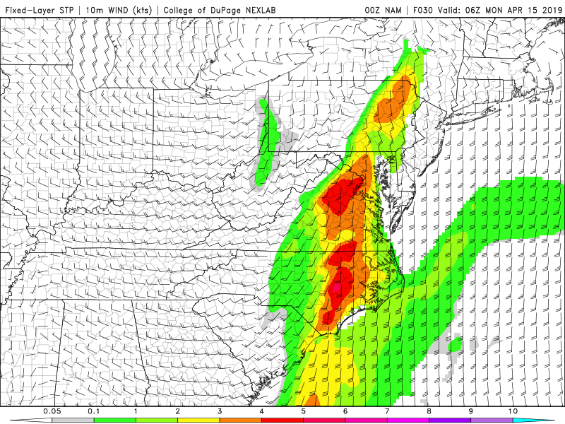
This sounding is just WSW of DC in Fairfax County at 06z MON on the 00z NAM NEST:
-
SWS at 1020 from KJAN states that a large and extremely dangerous tornado is over Starkville moving NE at 35
-
LWX had a great write up in their evening AFD that I posted in the catchall severe thread... dunno what Wakefield is saying though
-
-
@high risk @Kmlwx @C.A.P.E. @Eskimo Joe Excellently written updated evening AFD (posted at 951 PM) about the threat for late tomorrow into tomorrow night by the LWX mets... excellent points both for and against
- 2,802 replies
-
- 3
-

-
- severe
- thunderstorms
- (and 4 more)
-
Well now there is a tornado watch for them till 3am CDT lol
-
But it says "some thunderstorms"... take out the damaging wind gusts part and it makes it seem like they are saying some thunderstorms will be capable of producing a tornado. I like that it says that spotter activation is likely too
-
Interesting wording in the HWO about late tomorrow into tomorrow night. Usually it says something like an isolated tornado is possible... but instead says this:
