yoda
-
Posts
60,268 -
Joined
Content Type
Profiles
Blogs
Forums
American Weather
Media Demo
Store
Gallery
Everything posted by yoda
-
Mesoscale Discussion 0705 NWS Storm Prediction Center Norman OK 0346 PM CDT Mon May 20 2019 Areas affected...southwest and central OK Concerning...Tornado Watch 199... Valid 202046Z - 202145Z The severe weather threat for Tornado Watch 199 continues. SUMMARY...Tornado potential will likely increase across southwest OK during the next few hours. DISCUSSION...Radar mosaic shows several quasi-discrete supercells over the eastern TX Panhandle into the Low Rolling Plains. Additional storm development is possible over southwest OK ahead of the supercells located to the west. It is less clear regarding convective initiation and supercell development farther east towards the I-44/I-35 corridors (besides the Logan County supercell). Surface analysis shows lower 70s surface dewpoints with temperatures ranging from the lower 80s over southwest OK to the middle 70s near OKC. A composite front/outflow-reinforced boundary is located across the eastern TX Panhandle arcing to the east-northeast to near Stillwater, OK. South of this boundary, a very unstable to extremely unstable airmass will support intense updraft development with existing storms. KTLX VAD data shows a larger hodograph compared to KFDR's VAD (0-1km SRH of 300 and 200 m2/s2, respectively). Short-term model guidance has trended away from a possible scenario of discrete storm development over south-central OK. The most probable scenario involves several tornadic supercells likely moving across southwest OK and approaching the I-40 corridor west of the OKC metro. ..Smith.. 05/20/2019 ...Please see www.spc.noaa.gov for graphic product... ATTN...WFO...OUN...LUB...AMA...
-
Rotating wall cloud and baseball sized hail with the Collingsworth county cell in the panhandle of Texas
-
Tornado warning issued
-
Funnel cloud and wall cloud reported by spotters with the Matador TW cell (Dickens and Motley counties in Texas)
-
What does that mean?
-
BULLETIN - EAS ACTIVATION REQUESTED Tornado Warning National Weather Service Norman OK 224 PM CDT Mon May 20 2019 The National Weather Service in Norman has issued a * Tornado Warning for... South central Ellis County in northwestern Oklahoma... Central Roger Mills County in western Oklahoma... Western Custer County in western Oklahoma... * Until 315 PM CDT. * At 224 PM CDT, a severe thunderstorm capable of producing a tornado was located 8 miles southwest of Cheyenne, moving northeast at 35 mph. HAZARD...Tornado and hail up to two inches in diameter. SOURCE...Radar indicated rotation. IMPACT...Flying debris will be dangerous to those caught without shelter. Mobile homes will be damaged or destroyed. Damage to roofs, windows, and vehicles will occur. Tree damage is likely. * Locations impacted include... Cheyenne, Strong City, Roll, Angora, Moorewood and Dempsey. PRECAUTIONARY/PREPAREDNESS ACTIONS... TAKE COVER NOW! Move to a storm shelter, safe room or an interior room on the lowest floor of a sturdy building. Avoid windows. If you are outdoors, in a mobile home, or in a vehicle, move to the closest substantial shelter and protect yourself from flying debris.
-
Tornado Warning on the cell moving toward Cheyenne in Oklahoma
-
TW for Dickens and Motley counties in Texas
-
Mesoscale Discussion 0703 NWS Storm Prediction Center Norman OK 0137 PM CDT Mon May 20 2019 Areas affected...Texas Panhandle/West Texas Concerning...Tornado Watch 197... Valid 201837Z - 201930Z The severe weather threat for Tornado Watch 197 continues. SUMMARY...Rapid development of tornadic supercells expected in the next 1-2 hours. DISCUSSION...Convective initiation is underway across the Texas Panhandle and west Texas within an environment characterized by MLCAPE of 3500-4000 J/kg, effective bulk shear of 50-60 kt, and effective SRH of 300+ m^2/s^2. In addition, observed soundings launched by the TORUS field program in this area (Wellington, TX) indicate weak CIN and a favorable low-level kinematic environment for tornadoes in proximity to the developing convection, with a sickle-shaped hodograph and 0-1 km AGL SRH near 300 m^2/s^2. Convection that is developing now is expected to mature quickly, and given the ambient environment, storms should quickly evolve into supercell structures capable of significant, long-tracked tornadoes within the next hour or two -- in agreement with SPC objective analysis. ..Karstens.. 05/20/2019 ...Please see www.spc.noaa.gov for graphic product... ATTN...WFO...OUN...SJT...LUB...AMA...MAF...
-
Everything is >95% in the PDS Tornado Watch for Oklahoma
-
BULLETIN - EAS ACTIVATION REQUESTED Severe Thunderstorm Warning National Weather Service Amarillo TX 1227 PM CDT Mon May 20 2019 The National Weather Service in Amarillo has issued a * Severe Thunderstorm Warning for... Eastern Oldham County in the Panhandle of Texas... Western Potter County in the Panhandle of Texas... * Until 115 PM CDT. * At 1227 PM CDT, a severe thunderstorm was located 6 miles north of Vega, moving northeast at 30 mph. HAZARD...Two inch hail and 60 mph wind gusts. SOURCE...Radar indicated. IMPACT...Minor damage to roofs, siding, and trees is possible. People and animals outdoors will be injured. Expect hail damage to roofs, siding, windows, and vehicles. * Locations impacted include... Boys Ranch and Valley De Oro. PRECAUTIONARY/PREPAREDNESS ACTIONS... Remain alert for a possible tornado! Tornadoes can develop quickly from severe thunderstorms. If you spot a tornado go at once into the basement or small central room in a sturdy structure. This is a dangerous storm. Prepare immediately for large destructive hail capable of producing significant damage. People outside should move to shelter inside a strong building, and stay away from windows.
-
Surprised Wiz hasn't been focused on the MCD for SNE... 40% chance of a watch
-
-
Which thread are we using for todays event?
-
PDS Tornado Watch coming for W and C OK by 1-2pm CDT - https://www.spc.noaa.gov/products/md/md0699.html Mesoscale Discussion 0699 NWS Storm Prediction Center Norman OK 1117 AM CDT Mon May 20 2019 Areas affected...southwest into central OK...western north-central TX Concerning...Severe potential...Tornado Watch likely Valid 201617Z - 201845Z Probability of Watch Issuance...95 percent SUMMARY...A Particularly Dangerous Situation Tornado Watch will likely be needed for portions of central and western OK. Observational trends and short-term model guidance suggest a watch being issued during the 1pm-2pm period. DISCUSSION...Visible satellite imagery shows a bubbling cumulus field over western north-central TX into southwest and south-central OK. Rapid moisture advection is occurring late this morning with surface dewpoints rising into the lower 70s over southern OK. Upwards of 4000 J/kg MLCAPE is expected by early to mid afternoon across western and central OK with intensifying wind profiles. Short-term model guidance appears to have a reasonable depiction of free warm sector initiation occurring over southwest and south-central OK during the 2-3pm period. The observational trend in visible satellite imagery showing more pronounced bands of low cloud cover ---perhaps indicative of horizontal convective rolls and/or low-level confluence zones is supportive evidence for this model-based depiction. The expectation is for storms to develop on the northern half of these cloud features with explosive supercell development likely thereafter. Forecast soundings show a very rare combination of intense low-level SRH, very moist boundary, and extreme buoyancy. As such, the risk for strong to violent tornadoes appears to be increasing later this afternoon into the early evening. ..Smith.. 05/20/2019 ...Please see www.spc.noaa.gov for graphic product... ATTN...WFO...OUN...
-
Mesoscale Discussion 0698 NWS Storm Prediction Center Norman OK 1041 AM CDT Mon May 20 2019 Areas affected...portions of northwest TX...TX Panhandle...and western OK Concerning...Severe potential...Tornado Watch likely Valid 201541Z - 201815Z Probability of Watch Issuance...95 percent SUMMARY...A tornado watch will likely be needed by 1pm CDT. Storm initiation is expected as early as 1-2pm along the dryline. DISCUSSION...Visible satellite imagery shows the initial stages of a bubbling cumulus field across the Texas South Plains from near Midland northward to Lubbock. Late morning surface observations show south-southeasterlies with rapid moisture advection occurring with dewpoints rising to near 70 degrees F near the Low Rolling Plains. Despite the scattered low cloud cover, additional heating and moistening will contribute to extreme buoyancy (4000-5000 J/kg MLCAPE) developing by early-mid afternoon east of a sharping dryline in parts of northwest and west TX. The aforementioned theta-e increase and weak large-scale forcing will likely lead to storms explosively developing during the 1pm-3pm period. Strong and veering low-level winds beneath very strong deep-layer wind fields will likely result in sickle-shaped hodographs over the TX Panhandle and western OK this afternoon. 0-1km SRH around 250 m2/s2 coupled with the extreme buoyancy will favor long-track and potentially violent tornadoes with the strongest storms. Giant hail (3-4+ inches in diameter) will be possible. Farther south, tornadoes and very large hail are possible with any supercells that develop near the Permian Basin. ..Smith/Hart.. 05/20/2019 ...Please see www.spc.noaa.gov for graphic product... ATTN...WFO...OUN...SJT...LUB...AMA...MAF...
-
12z NAM looks okay I guess for Thursday afternoon
-
Quite a large hatched area for tornadoes
-
Blue box coming for W TX around 07z https://www.spc.noaa.gov/products/md/md0696.html
-
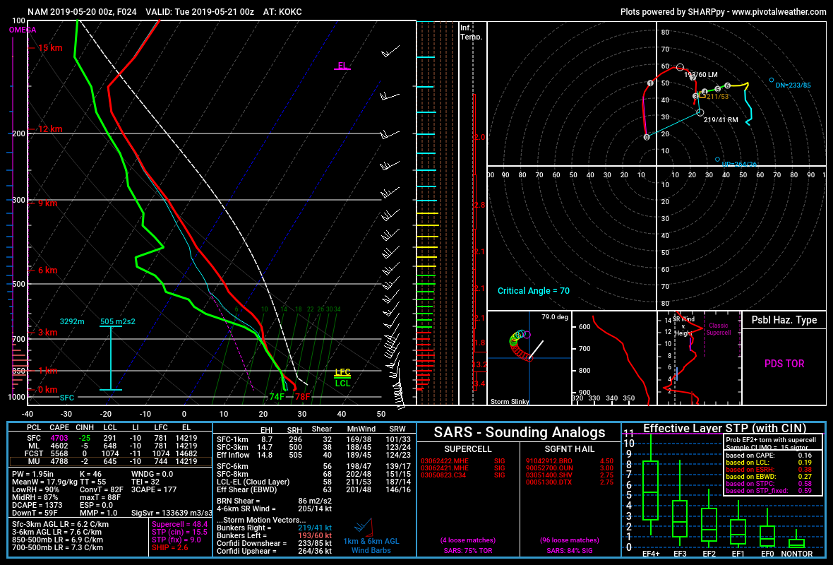
Um, 00z NAM sounding at KOKC at 00z TUES... is... a tad concerning
-
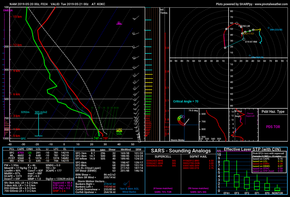
12z looked same as 00z I guess re CIPS?
-
Moore Public Schools will be closed tomorrow... seeing OKC is closed tomorrow as well https://mobile.twitter.com/MoorePublicSch/status/1130226134128504832 https://mobile.twitter.com/OKCPS/status/1130228146505232390
-
2 inch hail marker on radarscope and maybe some slight rotation?
-
STW till 9pm for NW portions of the LWX CWA
-
Clear Spring MD about to be crushed