

yoda
-
Posts
60,268 -
Joined
Content Type
Profiles
Blogs
Forums
American Weather
Media Demo
Store
Gallery
Everything posted by yoda
-
https://mobile.twitter.com/Wxmanms1/status/1133206961636483073 Says TDS of at least 15kft
-
Is it just me... or did it turn SE very quickly
-
https://mobile.twitter.com/USWeatherExpert/status/1133208395476086784
-
https://mobile.twitter.com/NWSILN/status/1133206253272911872
-
Its the top sports headline in DC... so...
-
So that's why Kuznetsov wants to fly after his goals... supposedly a video is out of two lines of cocaine and him in it right next to the lines
-
I'm confused... does this mean that the GFS is better for us than the NAM because the front moves toward us faster?
-
Wiz has to travel to East Cheyenne for softball sized hail https://mobile.twitter.com/NWSCheyenne/status/1132814605837750278
-
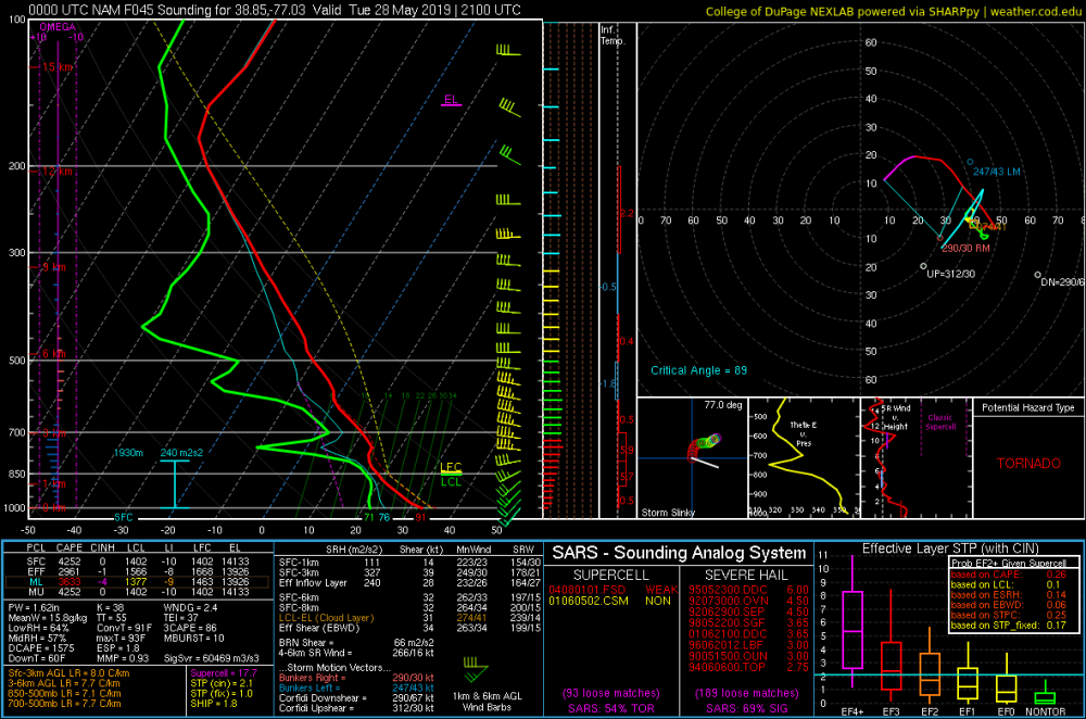
SARS is off the charts silly for hail at 21z TUES at KDCA
-
@Kmlwx @high risk 00z NAM tossing out some silly soundings again from 18z TUES to 00z WED lol ETA: Check out 21z TUES at KBWI
-
Looks like there are a few storms popping up ahead of the rain complex
-
I'm gonna guess that we in VA are done for severe unless that complex in E WV spruces up
-
Damn... that's an awesome pic!
- 2,802 replies
-
- 1
-

-
- severe
- thunderstorms
- (and 4 more)
-
I think we're going to set a record... 3 different MDs issued across the area and no watch lol... each MD had 40 percent chance too
-
LWX reissued the SPS Special Weather Statement National Weather Service Baltimore MD/Washington DC 542 PM EDT Sun May 26 2019 ANZ530>543-DCZ001-MDZ003>006-011-013-014-016>018-501>508- VAZ025>031-036>040-050>057-501>508-WVZ050>053-055-501>506-270000- Chesapeake Bay north of Pooles Island MD- Chesapeake Bay from Pooles Island to Sandy Point MD- Chesapeake Bay from Sandy Point to North Beach MD- Chesapeake Bay from North Beach to Drum Point MD- Chesapeake Bay from Drum Point MD to Smith Point VA- Tidal Potomac from Key Bridge to Indian Head MD- Tidal Potomac from Indian Head to Cobb Island MD- Tidal Potomac from Cobb Island MD to Smith Point VA- Patapsco River including Baltimore Harbor- Chester River to Queenstown MD-Eastern Bay- Choptank River to Cambridge MD and the Little Choptank River- Patuxent River to Broomes Island MD- Tangier Sound and the inland waters surrounding Bloodsworth Island-District of Columbia-Washington-Frederick MD-Carroll- Northern Baltimore-Southern Baltimore-Prince Georges-Anne Arundel- Charles-St. Marys-Calvert-Extreme Western Allegany- Central and Eastern Allegany-Northwest Montgomery- Central and Southeast Montgomery-Northwest Howard- Central and Southeast Howard-Northwest Harford-Southeast Harford- Augusta-Rockingham-Shenandoah-Frederick VA-Page-Warren-Clarke- Nelson-Albemarle-Greene-Madison-Rappahannock-Orange-Culpeper- Prince William/Manassas/Manassas Park-Fairfax- Arlington/Falls Church/Alexandria-Stafford-Spotsylvania- King George-Northern Fauquier-Southern Fauquier-Western Highland- Eastern Highland-Western Loudoun-Eastern Loudoun- Northern Virginia Blue Ridge-Central Virginia Blue Ridge- Hampshire-Morgan-Berkeley-Jefferson-Hardy-Western Grant- Eastern Grant-Western Mineral-Eastern Mineral-Western Pendleton- Eastern Pendleton- Including the cities of Washington, Hagerstown, Frederick, Ballenger Creek, Eldersburg, Westminster, Reisterstown, Cockeysville, Baltimore, Bowie, Suitland-Silver Hill, Clinton, College Park, Greenbelt, Laurel, Camp Springs, Glen Burnie, Annapolis, Severn, South Gate, Severna Park, Arnold, Odenton, St. Charles, Waldorf, Lexington Park, California, Chesapeake Beach, Huntingtown, Dunkirk, North Beach, Lusby, Prince Frederick, Frostburg, Cumberland, Germantown, Damascus, Bethesda, Rockville, Gaithersburg, Silver Spring, Lisbon, Columbia, Ellicott City, Jarrettsville, Aberdeen, Staunton, Waynesboro, Stuarts Draft, Harrisonburg, Strasburg, Woodstock, Mount Jackson, New Market, Winchester, Luray, Shenandoah, Stanley, Front Royal, Berryville, Lovingston, Charlottesville, Stanardsville, Madison, Orange, Gordonsville, Culpeper, Dale City, Manassas, Woodbridge, Lake Ridge, Montclair, Reston, Herndon, Annandale, Centreville, Chantilly, McLean, Franconia, Arlington, Alexandria, Falls Church, Falmouth, Fredericksburg, Dahlgren, Warrenton, Turnbull, Hightown, Monterey, Purcellville, Leesburg, Ashburn, Sterling, Big Meadows, Wintergreen, Romney, Paw Paw, Martinsburg, Charles Town, Shepherdstown, Moorefield, Bayard, Mount Storm, Petersburg, Elk Garden, Antioch, Keyser, New Creek, Ridgeville, Russelldale, Headsville, Fort Ashby, Riverton, Brandywine, Franklin, Oak Flat, Ruddle, and Sugar Grove 542 PM EDT Sun May 26 2019 ...Severe Thunderstorms Likely This Evening... Widely scattered thunderstorms will be popping up anywhere in Maryland between the Chesapeake Bay and the Appalachians, northern and central Virginia, eastern West Virginia, and the District of Columbia late this afternoon. Activity will become numerous this evening. Any thunderstorm today will be capable of becoming severe, with damaging winds and large hail being the primary threats. Anyone who plans on being outdoors should pay close attention to the latest forecasts. Stay alert for warnings and be prepared to seek shelter quickly should thunderstorms occur. If you see lightning or hear thunder, you are close enough to be in harm`s way.
-
Well SPC issued a 3rd MD... 3rd times the charm?
-
Afternoon LWX AFD
-
Another MD for the region https://www.spc.noaa.gov/products/md/md0811.html Mesoscale Discussion 0811 NWS Storm Prediction Center Norman OK 1245 PM CDT Sun May 26 2019 Areas affected...Portions of the Mid-Atlantic Concerning...Severe potential...Watch possible Valid 261745Z - 261945Z Probability of Watch Issuance...40 percent SUMMARY...Storms are beginning to redevelop in eastern West Virginia with damaging winds possible. Storm coverage will likely increase this afternoon, but severe coverage remains uncertain. DISCUSSION...Storms from this morning have continued over central/southern PA while the storms over Del-Mar-Va were unable to sustain themselves. New storms have begun to initiate in eastern WV with a building Cu field over northern VA. Severe storms remain likely over this area during the afternoon into the evening as thinking has not changed since MCD 808. Given the CAPE/shear, isolated supercells are likely with damaging wind gusts the main threat as low-level lapse rates steepen from daytime heating. Severe hail is also possible, but mid-level lapse rates are marginal. The lingering question remains severe storm coverage with uncertainty regarding how many supercells will develop or if any upscale organization can occur with the vorticity max/shortwave trough moving over the area. ..Nauslar/Thompson.. 05/26/2019 ...Please see www.spc.noaa.gov for graphic product... ATTN...WFO...PHI...AKQ...CTP...LWX...RNK...PBZ...RLX...
-
1630 SPC OTLK
-
Wonder if we'll pop a 30 wind today
-
https://weather.cod.edu/forecast/ NAM NEST Composite radar reflectivity 19z to 20z... then again around 02z
- 2,802 replies
-
- 1
-
-
- severe
- thunderstorms
- (and 4 more)
-
https://mobile.twitter.com/NWS_BaltWash/status/1132666644189327362
-
https://www.spc.noaa.gov/products/md/md0808.html Mesoscale Discussion 0808 NWS Storm Prediction Center Norman OK 1014 AM CDT Sun May 26 2019 Areas affected...Portions of the Mid-Atlantic Concerning...Severe potential...Watch possible Valid 261514Z - 261745Z Probability of Watch Issuance...40 percent SUMMARY...Storms are expected to develop and move east across portions of the Mid-Atlantic over the next few hours. Severe storm coverage is uncertain, but a few storms could become capable of severe wind/hail. A severe thunderstorm watch issuance is possible. DISCUSSION...Multi-cellular convection is currently moving eastward and developing across western PA and eastern WV/western MD. Per water vapor imagery and mesoanalysis a vorticity max is associated with this convection and remnant MCV may embedded within the western PA convection. For now, these storms appear to be elevated, but as insolation continues storms are likely to become surface-based. Ahead of these storms, a warm, moist airmass is in place with temperatures increasing into the 80s, especially across Del-Mar-VA, and dewpoints from the mid 60s to low 70s. Per mesoanalysis and forecast soundings, MLCAPE is currently 500-1000 J/kg and likely to increase to 1000-1500 J/kg in the next couple of hours as surface heating continues. Effective bulk shear of 40-50 knots with mostly unidirectional/speed shear will be sufficient for isolated supercellular storms. Additionally, as the boundary layer warms, low-level lapse rates will steepen, increasing chances for damaging wind gusts. Severe storm coverage still remains uncertain. While a few severe storms are likely to develop, coverage may not meet watch criteria, and poor mid-level lapse rates may inhibit severe hail production. However, convective trends will be monitored for a possible watch issuance with damaging wind gusts as the primary threat. ..Nauslar/Thompson.. 05/26/2019 ...Please see www.spc.noaa.gov for graphic product... ATTN...WFO...PHI...BGM...AKQ...CTP...LWX...
-
Haven't seen this issued one while... Special Weather Statement National Weather Service Baltimore MD/Washington DC 1040 AM EDT Sun May 26 2019 ANZ530>543-DCZ001-MDZ003>006-011-013-014-016>018-501>508- VAZ025>031-036>040-050>057-501>508-WVZ050>053-055-501>506-262045- Chesapeake Bay north of Pooles Island MD- Chesapeake Bay from Pooles Island to Sandy Point MD- Chesapeake Bay from Sandy Point to North Beach MD- Chesapeake Bay from North Beach to Drum Point MD- Chesapeake Bay from Drum Point MD to Smith Point VA- Tidal Potomac from Key Bridge to Indian Head MD- Tidal Potomac from Indian Head to Cobb Island MD- Tidal Potomac from Cobb Island MD to Smith Point VA- Patapsco River including Baltimore Harbor- Chester River to Queenstown MD-Eastern Bay- Choptank River to Cambridge MD and the Little Choptank River- Patuxent River to Broomes Island MD- Tangier Sound and the inland waters surrounding Bloodsworth Island-District of Columbia-Washington-Frederick MD-Carroll- Northern Baltimore-Southern Baltimore-Prince Georges-Anne Arundel- Charles-St. Marys-Calvert-Extreme Western Allegany- Central and Eastern Allegany-Northwest Montgomery- Central and Southeast Montgomery-Northwest Howard- Central and Southeast Howard-Northwest Harford-Southeast Harford- Augusta-Rockingham-Shenandoah-Frederick VA-Page-Warren-Clarke- Nelson-Albemarle-Greene-Madison-Rappahannock-Orange-Culpeper- Prince William/Manassas/Manassas Park-Fairfax- Arlington/Falls Church/Alexandria-Stafford-Spotsylvania- King George-Northern Fauquier-Southern Fauquier-Western Highland- Eastern Highland-Western Loudoun-Eastern Loudoun- Northern Virginia Blue Ridge-Central Virginia Blue Ridge- Hampshire-Morgan-Berkeley-Jefferson-Hardy-Western Grant- Eastern Grant-Western Mineral-Eastern Mineral-Western Pendleton- Eastern Pendleton- Including the cities of Washington, Hagerstown, Frederick, Ballenger Creek, Eldersburg, Westminster, Reisterstown, Cockeysville, Baltimore, Bowie, Suitland-Silver Hill, Clinton, College Park, Greenbelt, Laurel, Camp Springs, Glen Burnie, Annapolis, Severn, South Gate, Severna Park, Arnold, Odenton, St. Charles, Waldorf, Lexington Park, California, Chesapeake Beach, Huntingtown, Dunkirk, North Beach, Lusby, Prince Frederick, Frostburg, Cumberland, Germantown, Damascus, Bethesda, Rockville, Gaithersburg, Silver Spring, Lisbon, Columbia, Ellicott City, Jarrettsville, Aberdeen, Staunton, Waynesboro, Stuarts Draft, Harrisonburg, Strasburg, Woodstock, Mount Jackson, New Market, Winchester, Luray, Shenandoah, Stanley, Front Royal, Berryville, Lovingston, Charlottesville, Stanardsville, Madison, Orange, Gordonsville, Culpeper, Dale City, Manassas, Woodbridge, Lake Ridge, Montclair, Reston, Herndon, Annandale, Centreville, Chantilly, McLean, Franconia, Arlington, Alexandria, Falls Church, Falmouth, Fredericksburg, Dahlgren, Warrenton, Turnbull, Hightown, Monterey, Purcellville, Leesburg, Ashburn, Sterling, Big Meadows, Wintergreen, Romney, Paw Paw, Martinsburg, Charles Town, Shepherdstown, Moorefield, Bayard, Mount Storm, Petersburg, Elk Garden, Antioch, Keyser, New Creek, Ridgeville, Russelldale, Headsville, Fort Ashby, Riverton, Brandywine, Franklin, Oak Flat, Ruddle, and Sugar Grove 1040 AM EDT Sun May 26 2019 ...Severe Thunderstorms Likely This Afternoon and Evening... Thunderstorms are likely across the entire area this afternoon and evening. Some of the thunderstorms will be severe, with damaging winds and large hail being the primary threats. Anyone who plans on being outdoors during this time should pay close attention to the latest forecasts. Stay alert for warnings and be prepared to seek shelter quickly should thunderstorms occur. If you see lightning or hear thunder, you are close enough to be in harm`s way. The threat for thunderstorms will most likely be in two rounds. The first round through this afternoon may be more scattered in nature, but again some of those storms will be severe with damaging winds and large hail. More widespread showers and thunderstorms are likely this evening into the overnight hours ahead of a cold front, and some of these storms may be severe as well.
- 2,802 replies
-
- 2
-
-
- severe
- thunderstorms
- (and 4 more)
-
Glad to hear that you are all fine

