

yoda
-
Posts
60,268 -
Joined
Content Type
Profiles
Blogs
Forums
American Weather
Media Demo
Store
Gallery
Everything posted by yoda
-
If you read the AFD... you would see they said 4pm to 7pm for development
-
Yeah... we easily reached ConvT lol
-
LWX expanded the FFW Flood Watch National Weather Service Baltimore MD/Washington DC 152 PM EDT Tue Jun 18 2019 MDZ017-018-VAZ036>040-050-051-056-057-507-508-190200- /O.EXA.KLWX.FF.A.0005.190618T1800Z-190619T0300Z/ /00000.0.ER.000000T0000Z.000000T0000Z.000000T0000Z.OO/ St. Marys-Calvert-Nelson-Albemarle-Greene-Madison-Rappahannock- Orange-Culpeper-Spotsylvania-King George- Northern Virginia Blue Ridge-Central Virginia Blue Ridge- Including the cities of Lexington Park, California, Chesapeake Beach, Huntingtown, Dunkirk, North Beach, Lusby, Prince Frederick, Lovingston, Charlottesville, Stanardsville, Madison, Washington, Orange, Gordonsville, Culpeper, Fredericksburg, Dahlgren, Big Meadows, and Wintergreen 152 PM EDT Tue Jun 18 2019 ...FLASH FLOOD WATCH IN EFFECT UNTIL 11 PM EDT THIS EVENING... The National Weather Service in Sterling Virginia has expanded the * Flash Flood Watch to include portions of southern Maryland and Virginia, including the following areas, in southern Maryland, Calvert and St. Marys. In Virginia, Albemarle, Central Virginia Blue Ridge, Culpeper, Greene, King George, Madison, Nelson, Northern Virginia Blue Ridge, Orange, Rappahannock, and Spotsylvania. * Until 11 PM EDT this evening. * Thunderstorms with heavy rainfall are expected to develop across the watch area this afternoon and linger into the evening. Localized rainfall totals of several inches are possible. This could lead to flash flooding, especially in the urban areas. PRECAUTIONARY/PREPAREDNESS ACTIONS... A Flash Flood Watch means that conditions may develop that lead to flash flooding. Flash flooding is a very dangerous situation. You should monitor later forecasts and be prepared to take action should Flash Flood Warnings be issued.
-
60% today... yesterday was 40%... so I would believe so Would also probably mean that the SLGT risk at 1630 will be drawn more SWward -- when it decides to come out... its 10 mins late
-
LWX in their updated zones as of 10:37 AM has DCA reaching upper 80s for highs which would likely breach ConvT
-
Well LWX mentions it in their AFD, so they must either accept it on the SPC mesoanalysis page or have other stations to look at that support it
-
Um, there already is 1500 SBCAPE in NE MD
-
12z KIAD RAOB has FCST SURFACE of just below 2000
-
Updated morning LWX AFD:
-
Blue sky and sun here as well... guess we shall see how long this lasts
-
@mappy has received SLGT risk on the 1300 OTLK
-
Eskimo Joe likes this Flood Watch National Weather Service Baltimore MD/Washington DC 338 AM EDT Tue Jun 18 2019 DCZ001-MDZ003>006-011-013-014-016-501>508-VAZ052>055-501-502-505- 506-181545- /O.NEW.KLWX.FF.A.0005.190618T1800Z-190619T0300Z/ /00000.0.ER.000000T0000Z.000000T0000Z.000000T0000Z.OO/ District of Columbia-Washington-Frederick MD-Carroll- Northern Baltimore-Southern Baltimore-Prince Georges-Anne Arundel- Charles-Extreme Western Allegany-Central and Eastern Allegany- Northwest Montgomery-Central and Southeast Montgomery- Northwest Howard-Central and Southeast Howard-Northwest Harford- Southeast Harford-Prince William/Manassas/Manassas Park-Fairfax- Arlington/Falls Church/Alexandria-Stafford-Northern Fauquier- Southern Fauquier-Western Loudoun-Eastern Loudoun- Including the cities of Washington, Hagerstown, Frederick, Ballenger Creek, Eldersburg, Westminster, Reisterstown, Cockeysville, Baltimore, Bowie, Suitland-Silver Hill, Clinton, College Park, Greenbelt, Laurel, Camp Springs, Glen Burnie, Annapolis, Severn, South Gate, Severna Park, Arnold, Odenton, St. Charles, Waldorf, Frostburg, Cumberland, Germantown, Damascus, Bethesda, Rockville, Gaithersburg, Silver Spring, Lisbon, Columbia, Ellicott City, Jarrettsville, Aberdeen, Dale City, Manassas, Woodbridge, Lake Ridge, Montclair, Reston, Herndon, Annandale, Centreville, Chantilly, McLean, Franconia, Arlington, Alexandria, Falls Church, Falmouth, Warrenton, Turnbull, Purcellville, Leesburg, Ashburn, and Sterling 338 AM EDT Tue Jun 18 2019 ...FLASH FLOOD WATCH IN EFFECT FROM 2 PM EDT THIS AFTERNOON THROUGH THIS EVENING... The National Weather Service in Sterling Virginia has issued a * Flash Flood Watch for portions of Maryland, The District of Columbia, and northern Virginia, including the following areas, in Maryland, Anne Arundel, Carroll, Central and Eastern Allegany, Central and Southeast Howard, Central and Southeast Montgomery, Charles, Extreme Western Allegany, Frederick MD, Northern Baltimore, Northwest Harford, Northwest Howard, Northwest Montgomery, Prince Georges, Southeast Harford, Southern Baltimore, and Washington. The District of Columbia. In northern Virginia, Arlington/Falls Church/Alexandria, Eastern Loudoun, Fairfax, Northern Fauquier, Prince William/Manassas/Manassas Park, Southern Fauquier, Stafford, and Western Loudoun. * From 2 PM EDT this afternoon through this evening * Thunderstorms with heavy rainfall are expected to develop across the watch area this afternoon and linger into the evening. Localized rainfall totals of several inches are possible. This could lead to flash flooding, especially in the urban areas. PRECAUTIONARY/PREPAREDNESS ACTIONS... A Flash Flood Watch means that conditions may develop that lead to flash flooding. Flash flooding is a very dangerous situation. You should monitor later forecasts and be prepared to take action should Flash Flood Warnings be issued.
-
00z NAM soundings still look good for Thursday afternoon
-
https://mobile.twitter.com/markellinwood/status/1140775975002746881
-
I guess I must be missing something with Ellinwood and CWG and some writer named Cappucci
-
Lol and now you have storms coming
-
Fairfax county cell is sending out quite the outflow boundary right now
-
At 4:55 PM EDT, 2 W Callaway [St. Marys Co, MD] TRAINED SPOTTER reports HAIL of golf ball size (E1.75 INCH). SPOTTER REPORTED QUARTER TO GOLF BALL SIZE HAIL
-
Looks like a hail core near Leonardtown
-
Looks like something near Mount Rainier? Or no?
-
Storm near Bethesda now warned
-
-
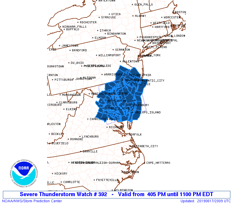
Severe thunderstorm watch issued till 11pm for i95 corridor and east URGENT - IMMEDIATE BROADCAST REQUESTED Severe Thunderstorm Watch Number 392 NWS Storm Prediction Center Norman OK 405 PM EDT Mon Jun 17 2019 The NWS Storm Prediction Center has issued a * Severe Thunderstorm Watch for portions of District Of Columbia Delaware Eastern Maryland Southern New Jersey Southeast Pennsylvania Eastern Virginia Coastal Waters * Effective this Monday afternoon and evening from 405 PM until 1100 PM EDT. * Primary threats include... Scattered damaging wind gusts to 70 mph possible Isolated large hail events to 1.5 inches in diameter possible A tornado or two possible SUMMARY...At least isolated strong to severe thunderstorms are expected to develop across the region late this afternoon within an increasingly unstable environment, with the potential for the strongest of these storms to produce severe hail/wind.
-
Looks like initiation near Harrisonburg
-
Lol too early to say that
- 2,802 replies
-
- 1
-

-
- severe
- thunderstorms
- (and 4 more)
